This blog is getting very disjointed I know, that’s all of the staying in Norwich causing that…. Anyway, my Friday evening involved meandering along to the Plasterer’s Arms, one of my favourite pubs in Norwich. It was the Legstretchers social event that was kindly organised by Maria and I think 12 or so people were there. Despite running Legstretchers for four years and being an active walker (sort of), I must admit to having been to more socials than walks over the last year, I’ll try and correct that at some point.
On the food front, as that’s my favourite aspect, the pizzas were a little small, but were perfectly tasty and I was delighted to be given the extra slices that others didn’t want. I must have looked the hungriest. Again. All told a very lovely evening, especially seeing some people who I haven’t been able to catch up with for a while.

Then on the Saturday there was the excitement of a day in Gorleston with Nathan. At Norwich bus station, I accidentally commented to the bus driver about how expensive First Bus have become and I think that annoyed him, so I probably shouldn’t have passed on my wisdom that public transport fares are going out of control. The driver said that it was cheaper than a taxi, which I accept is true, but that is hardly setting the value for money bar particularly high. It was a busy service but we found seats, although we moved to the back seats when the bus got to Great Yarmouth, as unlike in the Inbetweeners, there was no-one to throw us off.

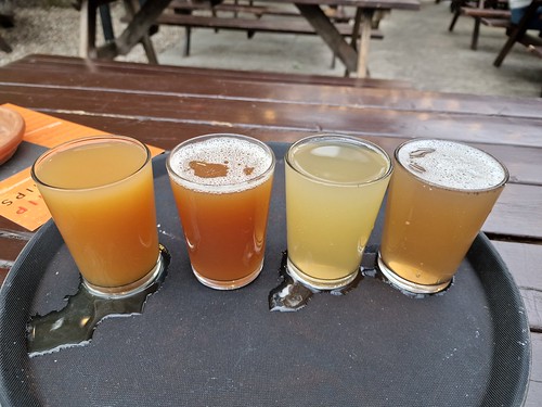
Several photos in this post are the ones that I took for Untappd, they’re not designed to be entirely representative of the beauty (or not) of the pub that we were in. This is the William Adams, operated by JD Wetherspoon, which was open the earliest for beer. I’ve visited this pub several times before, but never mentioned on this blog much else about it. It’s a relatively small pub for the chain, built on the site of a former chapel (and some graves were found when there was an archaeological dig) and is on one floor only, with the exception of the toilets.
The pub is named after a local hero, a lifesaver who managed to rescue 140 people from drowning, which is an exceptional amount given he wasn’t a lifeguard or member of the RNLI. Instead he worked as a swimming instructor on the beach and used that job to save anyone who was in trouble. He died in October 1913, aged just 49 and there is a now a road as well as this pub named after him, although I’m unsure which he’d be most pleased about. I’d like a pub named after me, or a railway station.
I had a quick look at the reviews, which are towards the higher end of the Wetherspoons scale (yes, it’s reached that point that I can judge that….) and one of my favourite themes came up:
“This [pub] one seems to be run by over zealous bouncers/thugs intent on squashing any fun out your evening by making sure groups of 35 to 45 year old ladies don’t laugh to loudly or have to leave the building?”
I think most people can imagine the back story here.
“S@#t place. No signs to say no kids after 9pm avoid at all costs.”
And this 1/5 review and although there are actually signs, are there many pubs that still welcome children in after 21:00? Nathan had a muffin thing, whilst I had already eaten, this is a reliable breakfast stop to be fair.

Next was Bar 1 and the staff member was friendly, apologising that it looked a bit of a state, but he explained a rugby team had just left. That’s a fair excuse for a slightly messy pub, but he was already cleaning it. It seemed a slightly odd name for a pub, but it’s well reviewed and seems to be popular in the local community, so that’s a win for everyone. Given it was only just midday, I was quite impressed at the amount of beer that the rugby team must have consumed.

The Timothy Taylor’s Landlord was perhaps a little past its best, but sufficiently drinkable for me not to worry about returning it. The glass did though have lipstick marks on it which definitely weren’t mine. Not ideal, but I liked the pub’s environment.

I’d say this is a decent pub for those wanting to watch sport and I liked the interaction from the staff member. The beer selection wasn’t particularly exciting, but the prices were reasonable.

Next was the New Entertainer, a quirky pub in numerous ways, including the shape and the main entrance which is at the rear of the building and leads straight out into a road. Not ideal after several pints. I wasn’t expecting much from this pub, but I very much liked it, it felt like one of those venues that you could easily make friends if new to an area. I went for the Fastolf Pale from Humpty Dumpty Brewery without much initial excitement, but this was very well-kept and had something of a depth of flavour. The pub is well reviewed on-line and although it perhaps felt initially like a local pub for locals it was all well managed, I’d certainly recommend it and they had three different real ales on.

Next was the Oddfellows Arms which was closed when we hadn’t expected it to be earlier in the day, so we returned later on. It took us a little while to work out how to get in, but it transpired that this is the back of the pub.

And this is the front of the pub.

This was perhaps the most modern of the pubs that we went to in terms of the beer options, this is the Camphillsner from Ampersand. Laid-back and friendly, I liked this venue. As an aside, I’m currently in Poland (Siedlce to be exact) and am on track to actually catch up with all my writing deficiencies this month. There will be a lot of time spent with my laptop in bars and cafes. What a time to be alive and all that stuff.

And a little bit of history, this is the oldest house in Gorleston, the medieval guildhall.

Next was the Feathers, a Craft Union pub, which has about as much craft beer in it as B&Q.

The service wasn’t what I would call overly welcoming, but it also wasn’t rude and in fairness it was busy, it’s a real community pub and there are low prices. Back on the Landlord from Timothy Taylor’s, it was well kept and tasted as it should, so no complaints there. The drinks options just aren’t very decadent for my liking, but it serves a purpose.

Next was the Dock Tavern and Nathan ensured that we were noticed by not being able to work out how to open the door. Actually, in fairness to Nathan (and I am very fair indeed) that’s the situation that I usually get myself into, so I have sympathy. Although that didn’t stop me doing an apologetic look at the locals to get some sympathy at the whole arrangement. The service at the bar was warm and engaging, with the Nog from Woodforde’s Brewery being well kept.

Nathan put this, the Short Blue, on our list of pubs to go to as a bit of a wild card, because it is well reviewed, but it isn’t known for its beers.

It was unfortunately a disappointment, the service wasn’t really there and the selection of real ales was limited to Woodforde’s Wherry. The beer was on the turn and if the pub had another ale I would have returned it, but as it was just drinkable, I persisted. The positive reviews appear to be for the food, but we weren’t there for that and it wasn’t available on the day of our visit anyway. But, we visited and gave it a chance, but it was more expensive than the other pubs and I can’t say I’ll be hurrying back.

With that it was time to walk back to the bus, past Mr Chi’s.

Beautifully kept exterior of the Subway.

Back on the bus, we were very excited to see Liam’s bridge as we drove by on the bus.

And there it is.

We had been tempted by the KFC in Gorleston because we’re into fine dining, but as the bus to Norwich turned up at that point, we decided to eat in Norwich. Subway was the location we picked, Nathan is a former regular here and I had a free six-inch sub, so win-win. Very delicious it was too.

Next it was Riley’s for pool and look at the delicious Guinness…. I like their careful pouring of the product in the appropriate glass.

After a strong start from Nathan, I caught up and we drew 4-4 before the lights went off at the table. Nathan insisted on playing in the dark and so he claimed the final frame even though it was nearly impossible to see. I didn’t say anything of course, I pretended he could have the victory, but I bet Ronnie O’Sullivan wouldn’t have counted frames he played in the dark.

A quick one in the Malt and Mardle, a wonderfully friendly venue and I’ve done an interview with them. A rather lovely IPA from Brew By Numbers, with the service being warm and conversational as usual. This micropub is well worth a visit, and indeed, I got them extra customers the previous evening when I kept recommending them.

The Artichoke was busy so we were forced to sit outside, with two women coming to ask if they could sit on the other end of the table. Then their two friends plonked themselves down between us, which equally annoyed Nathan and me (we get annoyed easily, sometimes by the same thing and also by bad beer), but we’re too laid-back to say anything or even look slightly annoyed.

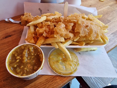
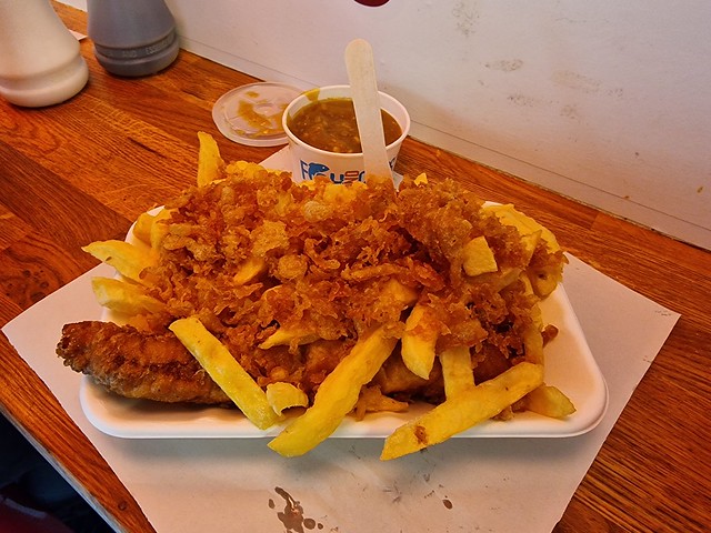
I’ve been meaning to go to the Star Fish Bar for a while, as it’s located the rather excellent Leopard pub. It was all a bit generic and basic, although at slightly expensive prices. Nothing disastrous, but it’s way off the quality of Lucy’s, I now demand a butcher’s sausage and no generic rubbish.

Nathan won at bar billiards, I’ll give him that. We played this one in the light. He’s getting a lot better to be fair. Nathan only knew about 28 other customers in the King’s Head, so a lower number than normal. He’s very social.

Pickled eggs and beer, what a combination. Anyway, I thought that we were on top form on this expedition, full of exciting new ideas and the like, one of my favourite days out in a while. All really rather lovely.