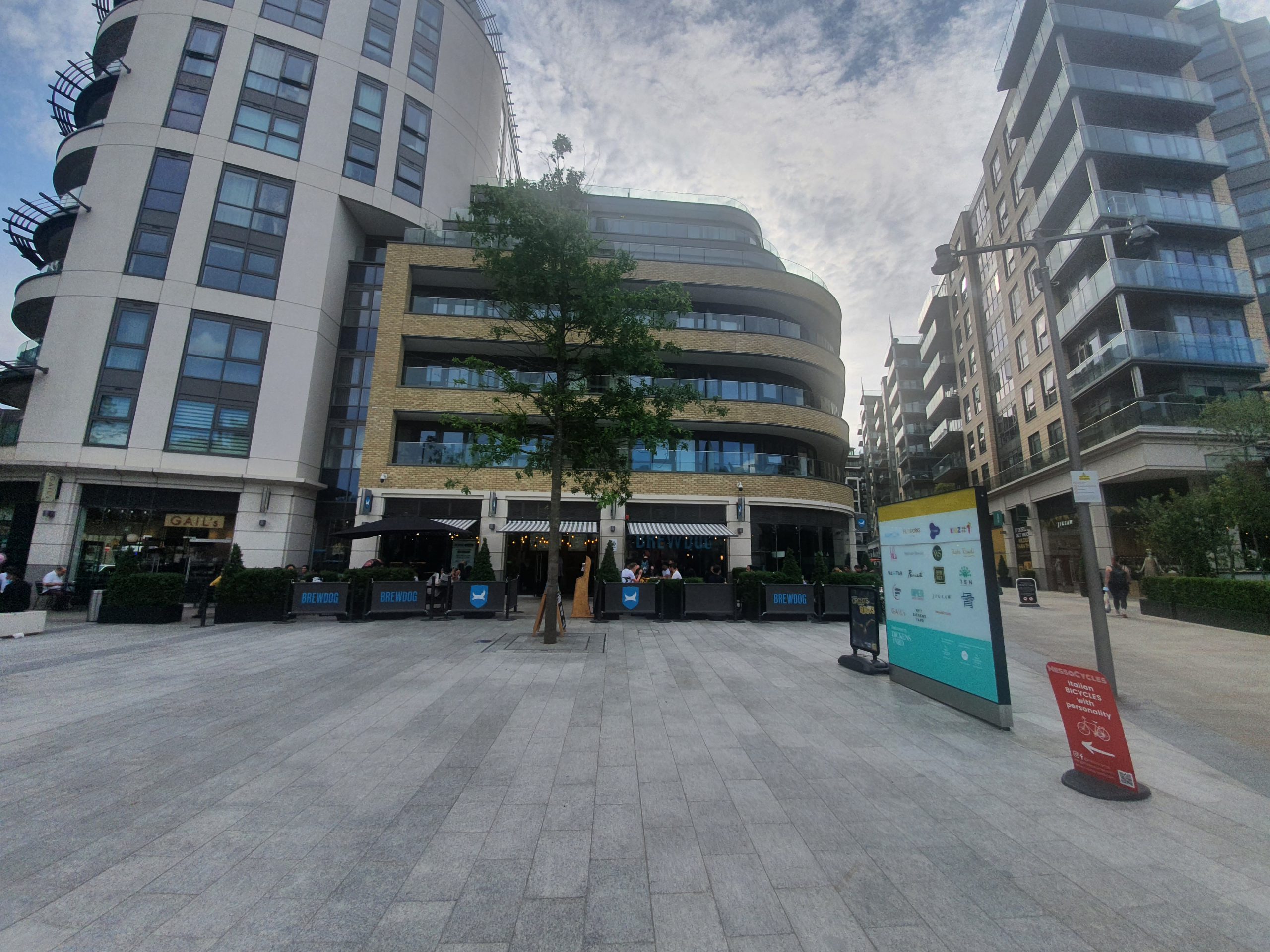
Category: UK

  • Norwich – Speeding, Road Rage and Hit & Run in 1871

    Norwich – Speeding, Road Rage and Hit & Run in 1871

    150 years ago this week, there was a case heard in the Shirehall in Norwich with a Mr. J. Longs in the chair and it’s quite an early case that combines speeding, road rage and hit & run. I’m not sure that I’ve read about an earlier case involving these breaches of road etiquette, but I’m sure that Colonel Custance wasn’t entirely pleased to hear about this incident.

    Incidentally, the above image is from Attlebridge, on the old Norwich and Fakenham turnpike road, although I don’t know where exactly the accident took place.

    I shall quote the case from the Norwich Mercury:

    “William Dann, teamman, in the employ of Colonel Custance, was charged with driving furiously on the Norwich and Fakenham turnpike road on Tuesday last, and causing wilful damage to a cart driven by Mary Ann Fisher, of Reepham. It appeared that the complainant was driving home from Norwich when she overtook the defendant, who was at that time driving quietly. After passing him, however, defendant whipped his horses and dashed along, apparently with the view of getting before the complainant, who drew close to the edge of the road, but could not avoid a collision.

    The result was that defendant’s wagon caught the wheel of complainant’s cart, smashing it to pieces. The woman was thrown out of her cart, and became unconscious, but notwithstanding this, the defendant drove on without rendering any assistance. The amount of damage the defendant had already agreed to pay, and pleading guilty to the charge, he was now fined 5s and £1. 9s. 6d costs”.

  • Norwich History by Parish : St. Etheldreda

    Norwich History by Parish : St. Etheldreda

    And a new little project that Jonathan and I are undertaking because this lockdown is clearly here for at least a few more weeks. It’s a bit niche (our project I mean, not the lockdown), I’ll accept that, but there we go. Effectively, it’s walking around Norwich, ancient parish by ancient parish and seeing what is there now compared to a map from the 1880s (the map above is from 1789, but the one from the 1880s is more detailed, which is why we used that). There’s a PDF of these boundaries to provide some extra background to this whole project.

    St. Etheldreda is the seventh parish we’ve visited and is one of the smallest in terms of its physical size. When we started this parish I had wondered whether there would be much of interest, as great swathes of it have been destroyed and replaced with modern housing. However, some elements remain and it was a suitably intriguing challenge to work out where the roads once were in relation to where we were standing.

    As for the destruction of much of this parish, which was partly pre-war slum clearance, partly air raid damage but mostly post-war clearances. It’s easy to be critical of the council that they destroyed so much history, but that should be tempered with the situation that they had residents needing decent housing, they had war-damaged properties and also poor quality housing. It’s too simplistic perhaps to just condemn the council for bull-dozing history given the limitations that they had.

    However, even after noting that, I personally think that the council made substantial mistakes with this huge rezoning. They retained little, with most streetlines being lost and the heritage they could have saved was just bulldozed away. There was all manner of local opposition and numerous historic buildings were lost, despite the hopes of locals that they could be saved. The council by all accounts disregarded these attempts to save elements of the area, which is perhaps a great shame.

    So it all means that there is no anchor to the past, they created a new community that feels a little separate from Norwich city centre, despite it being a very short walk away. The council demolished Mariners Lane which connected King Street to Ber Street and broke the direct link between the two areas. Instead, they ploughed a new street, Rouen Road, through the middle of what was once housing which now has several car parks and under-used sites along it.

    It appears from the media that the reason that the council did this was because they initially expected the site to be entirely reused, even as a university site, although the University of East Anglia were attracted by more spacious surroundings outside the city centre. This would therefore make more sense in terms of demolishing the area, although perhaps the council might have got clarity on that before tearing everything down.

    The EDP has a photo of what this area looked like in the early 1960s, and that street heading down to the middle of the photo is Mariners Lane.

    And here is that same location today, Mariners Lane, which is now a cul-de-sac leading off from Ber Street. This is in St. John De Sepulchre parish though, so we mostly ignored this today.

    This photo is taken at the base of the hill, looking at Normandie Tower, which is I think the only tower block in Norwich City Centre. I initially thought that this piece of hill was original, but it isn’t, this is where Mariners Lane came down.

    This photo is taken in the same place as the previous one, but facing the other way and looking at Rouen Road.

    Clicking on the above map makes it bigger. I was standing on the final T of “William Street” on the map when taking the photos, with Normandie Tower being pretty much on top of Compass Street.

    Now standing on Rouen Road at what appears to be some sort of temporary bus station that First have created for themselves, with Normandie Tower in the background.

    This is the route of Mariners Lane, now demolished here.

    This photo is taken in (nearly) the same place as that taken by George Plunkett in 1935. On his photo, it’s possible to see the sign for the Congregational Mission Hall at Sherbourne Place where services took place on Sunday evenings at 19:00. This has now been demolished, as have all of the malthouses which stood along here.

    This is where the malthouses once stood. The buildings on the right are the rear of the properties fronting onto King Street. The council tore down many buildings along King Street, but on numerous occasions there was local opposition which ensured that the properties were maintained. Although King Street might have lost some of its history, it hasn’t been decimated.

    This is the church from which the parish takes its name, a now redundant (in religious terms) Grade I listed building which dates from the twelfth century, with additions made in the fourteenth century and a substantial Victorian restoration. It’s now in use by an arts organisation and I’ve been inside on a heritage day weekend, I’ll retrieve my photos from that weekend at some point.

    The churchyard is in quite a state in numerous different ways, not least because some of these littered about the place.

    The Norman style doorway, which is actually probably Norman……

    A photo taken from the grounds of Normandie Tower, looking back into the churchyard.

    The church, looking quite pretty here. The roof was thatched until the Victorian restoration.

    Something doesn’t feel right about this being here, I’m wondering whether this has been moved from inside the church. It might have been on top of a box tomb, but I’m not convinced this was its original placement.

    A broken stone in the churchyard.

    The north side of the church.

    I am still yet to be convinced that using gravestones as some sort of garden feature is appropriate or respectful. Others may have different views.

    This is the end of the parish, and the Ferry Boat Inn is at the rear, across the parish border. And an explanation of that, the parish of St. Julian’s is located both to the north and south of the St. Etheldreda parish, it’s a strange split. Anyway, somewhere on the left the Rainbow pub stood until 1959, which backed onto the parish boundary.

    This car park is on the former site of the Crown Brewery, which occupied a large site along the river from the early nineteenth century. The National Archives note that “the Crown Brewery was gradually acquired by the firm of brewers known variously as Baseley, Youngs and Roe, Youngs and Burt, Crawshay and Youngs, and Crawshay, Youngs and Youngs, in the years” and it closed in the middle of the twentieth century. A few of the buildings from that period survive and the brewery also owned the Music House building, more of which later on in this post.

    Photos from the Crown Brewery site, with the River Wensum visible.

    Some decoration in the foliage.

    A mural on the wall, with some not ideally placed bins. I understand that this was designed by Walter Kershaw in 1984 and it features numerous elements of Norwich’s history. The mural is on the reverse of the building, so it’s not visible from King Street itself.

    The buildings on the right, 176-178 King Street, are also visible in George Plunkett’s photo from 1936.

    This is the former Ship pub and another loss, in my opinion, to King Street as this would have made for a quite marvellous licensed premises. George Plunkett yet again helps me here, this is the pub in 1939 and the EDP have one from a not dissimilar period.

    Not only will I link to George Plunkett’s marvellous photos, I shall also quote his text about this:

    “The yard to its south has at some time been partly built over, so that while formerly wide enough for the passage of carts it will now accommodate only pedestrians. The finely carved lintel above bears a design of foliage together with the rather contradictory inscription “Princes In”; it is believed that this was brought here at some time from the famous inn of that name, first mentioned in 1391, which once stood in St George Tombland parish on the north side of Princes Street”

    It’s also quite visible in this photo just how the width has been narrowed.

    The old name of the yard.

    Inside the yard, which is blocked at the end and there’s nothing older behind these buildings, it’s all been demolished.

    The old entrance to the Ship Inn, which ceased being a licensed premises in 1969.

    Wooo!!! Some survivors on the outside of the pub, with our parish of St Etheldreda on the left hand one from 1786. The two on the right both relate to the parish of St. Julian (the J was once used more interchangeably with the I) but in two different formats, one from 1800 and the other from 1825.

    On the other side of the road from the Ship Inn is 167 King Street, or the Music House. This is also on the edge of the parish boundary and some of this structure dates to the twelfth century. The undercroft is now Jurnet’s Bar and is full of character and history, taking its name from a man known as Jurnet the Jew, who purchased the building from John Curry in 1225. Once a house for the wealthy, this area became a little less glamorous over time, so the building was split up into tenements in the eighteenth century. It is the only non secular building from the twelfth century to survive in Norwich and it’s used today by Norfolk County Council. Behind here was the Crown Brewery, who owned the building for much of the nineteenth and early twentieth centuries.

    These parish boundary markers are on the Music House, with the parish of St. Julian off towards the left of this photo and this has markers from 1789 and 1825, with the marker for St. Etheldreda dating to 1786. I like that one of these iron parish boundary markers was placed here in the year of the French Revolution, that’s a quite remarkable survival really given everything else that has changed in this area.

    And a look back down towards the parish of St. Etheldreda, a really quite fascinating section of street.

  • Norwich History by Parish : St. John Baptist Timberhill

    Norwich History by Parish : St. John Baptist Timberhill

    And a new little project that Jonathan and I are undertaking because this lockdown is clearly here for at least a few more weeks. It’s a bit niche (our project I mean, not the lockdown), I’ll accept that, but there we go. Effectively, it’s walking around Norwich, ancient parish by ancient parish and seeing what is there now compared to a map from the 1880s (the map above is from 1789, but the one from the 1880s is more detailed, which is why we used that). There’s a PDF of these boundaries to provide some extra background to this whole project.

    St. John Baptist Timberhill is the sixth parish we’ve done this for and, again, there’s substantially more history than I can mention in this post, a reminder of just how much heritage remains in Norwich. As can be seen in the above PDF, these boundaries are not that neat and they follow the lines of buildings that have long since gone. I’m generally spelling Timber Hill as two words, but views on this seem to differ, but I won’t let it overly worry me…..

    This is the area of Norwich that we were meandering around. And, this parish was difficult to follow, not least because the entire cattle market area to the north of the former parish has disappeared and has been replaced by the Norwich Castle Quarter shopping centre, but also because the Rouen Road area has been entirely changed in post-war developments.

    Starting off at St. John the Baptist Church, which was open and offering a friendly welcome. I took numerous photos in the church, but I’ve written about this building before and shall just refer back to that. Nearly no graves remain in the churchyard, but they appear to have been removed long ago, and little of the exterior remains. The church’s tower collapsed in 1784, during a period when many Church of England buildings were neglected as the number of people attending services started to fall, and it was never replaced.

    We first went to the southern end of the parish, which is now the beginning of Ber Street, but this section was once considered to be part of Timber Hill. Also visible in the above photo is the entrance to White Hart Yard, which was named after the pub which once stood at its entrance. The pub closed in 1940 for the duration of the war, but it was then bomb damaged and became derelict, so that re-opening never happened.

    This is perhaps something of a loss, this was the Kings Arms and George Plunkett took a photo of it in 1979. It had traded as a pub since the first few years of the nineteenth century, was damaged during the Second World War, but then repaired and it remained open until 1968.

    The former Cullings Coaches building, a independent bus company which operated from Norwich.

    The parish boundary stops about here somewhere where it meets St. Michael at Thorn parish. The back of these buildings on Ber Street would have once been yards which stretched back some distance, but this has all gone now, and that’s the back of the Archant building at the rear.

    This is on the other side of Ber Street and is the Bonds building (operated by John Lewis) and this is a post-war building as their rather lovely previous shop got destroyed during the Second World War. George Plunkett has a photo of the Bonds building from 1935, which would have perhaps been one of the iconic images of the city if it had survived the war.

    Bonds (or John Lewis) today, although the area on the right is in a different parish, but there was no evidence of any old parish markers here to show where that line was exactly.

    We then went back to St. John the Baptist Church and walked back towards the city centre along Timber Hill. This is a vastly improved road and the city council have done a decent job here, with pedestrianisation making it a much more walkable area and there are numerous cafes and restaurants along here. Older photos show a busy road and pedestrians shoved to one side, so this is a more pleasant area to be now.

    The entrance to Scotts Court, not to be confused with Scotts Yard on nearby Ber Street. On the other side of the road here is the Castle Quarter shopping centre (formerly the Castle Mall) which means little original from this area remains.

    And a parish marker at last and many of them have gone missing from this area, with PAS meaning the Parish of All Saints.

    The entrance to Lion and Castle Yard, which leads off Timberhill and is in the parish. It takes its name from the Lion and Castle pub which was located here between 1822 and 1925, with a sign also noting that the lion and castle are on the city’s coat of arms.

    This building in the yard is one of the few thatched structures that still remain in Norwich and it is now one single property that was combined from two seventeenth century cottages. The building was restored by the Norwich Preservation Trust in 1996 and it’s likely that weavers would have once lived in the properties. George Plunkett took a photo of this location in 1935 and the area has a rather different feel today to back then.

    Back on Timber Hill, this is the former Baptist Particular Chapel, which was originally built as a warehouse in the eighteenth century. It was purchased by the Particular Baptists in 1832 for £1,150 and then converted into a chapel, a usage that it retained until 1975. More recently it has been converted into a restaurant and bar.

    Looking back up Timber Hill, with the Murderers Pub on the left.

    This is the birthplace of Sir Arthur Michael Samuel (1872-1942), who was the first Jewish Lord Mayor of Norwich. He later became the Conservative MP for Farnham, the Secretary of Overseas Trade between 1924 and 1927 and then the Financial Secretary to the Treasury until 1929.

    This is where Timber Hill meets Orford Hill and George Plunkett took a photo in 1984 of that stag being lifted onto the roof. There’s a blue plaque on that building which noted that George Walpole, the Earl of Orford (1730-1791) was seen as a bit of an eccentric at the time, but he gave generously to public subscriptions to fund planning improvements. This section of the street, which is also where three parishes meet, was renamed from Hog Hill to Orford Hill in his honour.

    Orford Street, looking down towards Farmers Avenue.

    The Bell Hotel from the Orford Street side. This large building is no longer a hotel and is operated as a JD Wetherspoon pub and is one of their first in the country to have opened outside of London. Sections of the structure remain from the fifteenth century and it has been known as the Bell (or the Blue Bell) since at least 1696. Revolutionary groups met here in the eighteenth and nineteenth centuries (and frankly, I can think of a few that have met here over the last few years, but that’s a different matter) and it was also used by the American Women’s Army Air Corps during the Second World War.

    The front of the pub, from Castle Meadow.

    The rather grand entrance, which was formerly the way into the stables of what was then a coaching inn.

    This area has all changed now, with Norwich Castle in the background, Farmers Avenue now has the Castle Quarter structures on it.

    The entrance to Orford Hill on the right, but once again, everything behind that has changed with the shopping centre development.

    The entrance to the cinema.

    This is the only remaining older section of this road, with what was Number 12 at the rear, a now permanently closed restaurant that was located in a building with parts remaining from the seventeenth century.

    The rear of Number 12.

    This building, 18 Golden Ball Street, was saved and now sits a little awkwardly within the Castle Quarter shopping centre structure. George Plunkett took a photo of this property in 1936, but everything else around here has gone. To the left of these structures is St. John the Baptist Church, where we started our little meander.

    There’s also a parish boundary marker located on the front of the building and I wondered whether it was put there as part of the renovation and heritage of the building. However, it’s also visible in the old photo from George Plunkett and it stands for St. John Timber Hill.

    The Archant building, which is perhaps not the most liked structure in terms of its design, but is something a little different and I’m sure it’ll become an important part of the architectural history of the city. Long since the home of the EDP, the building was sold by their owners Archant in 2019 to Alan Boswell Insurance, but they retain a floor in it. New ways of working and changes to regional newspapers (primarily they don’t sell many now) meant that Archant didn’t need as much office space, hence the downsizing arrangement.

    Paid for by Archant, or Eastern Counties Newspapers as they were, this sculpture is by local man Bernard Meadows (1915-2005).

    The car park of the Archant building, where once there was housing.

    This is Paradise Place which is an old name for the streets here, but they were changed in the post-war period when a new housing development was placed here. Personally, I think this area has been botched in terms of its atmosphere (given there’s a busy road and big car park by it), as it doesn’t feel like part of the city and the old streetlines were lost. However, I’m sure that the quality of housing is better than what was here before, so the residents were perhaps rather quite pleased. And, I do like old streetlines to be maintained, so perhaps I’m just being biased.

    And that concludes another parish, one which isn’t necessarily geographically huge, but which again contains a fair chunk of history. As usual, I’ve had to omit many stories from this account as there are far too many to tell, but it’s a reminder of just how much there is remaining in Norwich from the past.

  • Fundenhall – St. Nicholas’s Church (Gerard Barton)

    Fundenhall – St. Nicholas’s Church (Gerard Barton)

    This memorial tablet commemorating the life of the Reverend Gerard Barton is located on the wall of St. Nicholas’s Church in Fundenhall.

    The tablet usefully explains the significance of Gerard’s contribution towards the church, namely that:

    “As a layman, in the absence of a resident minister, he was a father to the people, restored this church and for fourteen years was a bright example of truth, uprightness and charity to all around”.

    Gerard was born on 19 September 1834 in Stoughton, Sussex, the son of John Barton and Frances Barton. He married Elizabeth Hazard in 1856 and they had twelve children between the years of 1858 and 1879. The youngest, Conrad Barton, was born at Freiburg in Baden where Gerard was serving as a Chaplain. He returned back to Fundenhall where he continued to live in The Grange (a building which is still standing today) and the family clearly retained some wealth given that they had six servants at the property at the 1881 census.

    The church was in the 1850s crumbling and in risk of collapse if nothing was done about it. Barton was the main funder of the entire project and it was he who commissioned Richard Phipson to undertake the repair and restoration work. It was only in the last fifteen years that another restoration project was necessary, thanks to the funding that he provided back in the 1860s.

    Gerard died at his house at 10A Kirkley Cliff in Lowestoft on 6 October 1889, at the age of 55. As an aside, one of his daughters, Madeline Barton, married William Horace Lascelles (1868-1949) and his half-brother was Henry Lascelles, whose son married Princess Mary, who was the daughter of King George V.

  • Fundenhall – St. Nicholas’s Church

    Fundenhall – St. Nicholas’s Church

    It’s fair to say that this church in the Norfolk countryside isn’t typical of the area in terms of its design and its central tower. There’s something quite magnificent about it though, that tower makes quite a statement. And another statement that this church made was that it was open to the public and seemingly proudly so. Other nearby churches weren’t open and we met someone who commented that the building’s keyholder wasn’t letting them in even though they were only a few doors down. The current Covid-19 situation is inevitably going to cause issues, but these stories of churches remaining firmly closed to other than the select few are perhaps far too common. However, there were no access issues at Fundenhall, it seemed to be a place that the Church of England was proud of.

    The glorious central tower is original, dating to the twelfth century, although the top section may be later.

    Potential tragedy hit this church in 2004 when it was forced to close due to falling masonry. This Norman period church is not in an area which is surrounded by residential properties and there are multiple other churches within easy walking distance. That put a pressure on the congregation beyond what they might reasonably have been expected to cope with. But, with some ingenuity and support of the Lottery Heritage Fund, individuals and businesses, they were able to get the repairs completed and re-open the building in May 2010. It was no quick fix either, the repair and restoration work cost £250,000. The church was fortunate, if the falling masonry had been twenty or thirty years earlier, then this building might not have been repaired.

    The north side of the church, although since Heritage Lottery funding has allowed the construction of a rear car park, entrance is mostly through the south side of the building. The porch is now closed off to the public, but is architecturally of little interest since it was added in the nineteenth century. The bulk of the building, excluding the tower, dates from the fourteenth century.

    A now blocked window on the church’s north side.

    Since a visit I made to a church last week which pointed out medieval graffiti, I’ve been on the lookout for it. The cross appears to be pretty old to me (I’m not sure that this is a phrase used by professionals, but there we go) and was perhaps once covered in limewash.

    I was pleased to see a Norman style doorway, but this according to the listed building record is an actual Norman doorway that is unmoved from its current position.

    The inside of that same doorway and that wooden door is of some considerable age.


    The beauty of this church wasn’t limited to the exterior as the interior was bright and open. The rood screen might have gone, but the surround (or coving I think it’s called) has survived, so that must be from before the Reformation. Older books, not least Blomefield, suggest that this rood loft was more complete in the eighteenth century and painted work was still visible. There was an extensive nine-month long repair project which took place in 1869, where there was also some re-ordering and so it seems likely that the damage was done then.

    A newspaper report from the Norfolk News in 1870 is more generous, talking of the Portland cement used in the chancel and the retiling of the nave with Minton tiles. It’s added that the rood loft was protected by taking it down and moving it to the west end of the church, but there’s an awful lot of “new” things being mentioned in the report, a logical indication of how much has been lost.

    The original drawing made by the architect Richard Phipson from that 1870 renovation, with the big new oak benches visible. I wonder where they are today, as they appear to have only been removed in the recent repair work to the church as they’re in George Plunkett’s photo from 1996. There’s an old photo of the interior of the church here.

    This is rather lovely, it was funded by the Heritage Lottery Fund and local families, entitled “Reconnecting with Fundenhall’s Fallen” and was created by Kate Munro.

    That’s much friendly than a “do not touch” sign, I like it.

    Looking back down the nave.

    This was the entrance to the rood stairs and also to the tower, a handy advantage in having a central tower. The bells are still in the tower and can be rung, although there was a little incident in 1 August 1885 when John Atkins “let go of the bell rope, fell backwards and expired”.

    The font is from the fifteenth century, so that was here whilst the Reformation was taking place and parts of the building were being torn down around it. The location of the font has been moved from its previous place at the rear of the nave.

    Some of the old flooring is visible through this panel, although it was a bit misted up and so not entirely clear.

    The chancel.

    The priest’s door leading off of the chancel.

    There were numerous eighteenth century graves in the churchyard, but more of these in later posts. For anyone engaged in the detail of the church’s architectural history, there’s a comprehensive document which was produced in 2007 during the restoration work.

  • GeoGuessr (Norwich Version) – Walk 5

    GeoGuessr (Norwich Version) – Walk 5

    I already have a better explanation (well, longer explanation anyway) for this plan. In essence, whilst lockdown is on, I need to find ways of walking nearby to Norwich in quiet areas for my LDWA 100 training. So, I’m using GeoGuessr to pick out five random locations within a certain area which I’ve defined and then walking to them, to see what kind of story I can uncover.

    The five random locations, all fairly close to the city centre, so this ended up being a walk of just under seven miles. Nathan was helpfully understanding when I turned up late as I bumped into (not literally) someone I knew.

    It’s a little difficult to find anything new in the centre of Norwich given how much I’ve been traipsing around it, so the more mundane may become more predominant. But, perhaps there’s something just as magical about these old stones under the road surface than a building that was constructed at the same time. The paving here on Barrack Street is likely the best part of a century old and it was part of a long roadway down towards the River Wensum, although it’s mostly gone now.

    This was the first location, Whitefriars Bridge, which I’ve written about before…..

    This, until recently, was the Del Ballroom on Waggon and Horses Lane which was used until 2013 as a dance studio. Norwich City Council decided that as there was a dance studio nearby, this interesting and quirky building could be torn down, despite some local objections from nearby property owners. I suppose it’s not a hugely historic building, as it was only built in the 1930s, but it added some character to the local area. The seven new properties they’re cramming into the site don’t have car parking provided and no right to a permit, so it’s all quite environmental in terms of not adding cars to the roads of Norwich. Anyway, I digress……

    Our second location and this photo was taken from just outside the rather lovely Strangers’ Hall Museum. The Strangers were Dutch Protestants who were invited to live in Norwich by the city authorities and so many came that they eventually comprised a third of the city’s population. They did much to boost the textile trade in Norwich and also helped the local economic situation, with relatively little evidence of any animosity between locals and incomers. There’s a strong legacy in the city today of Dutch style buildings and it was the migrants that brought over canaries, which is the city’s football symbol today.

    This is the former site of St Benedict’s Gate, also known as Bennet Gate and Westwyk Gate, which was demolished at the end of the eighteenth century. A little bit of this gate survived until the Second World War air raids destroyed it, as can be seen in this George Plunkett photo. Today, the route of the city wall and the outline of the city gate is marked out in brick paving which is always a marvellous idea.

    The line of the wall looking up towards Grapes Hill.

    Our third location, the former Britannia pub.

    The pub was opened in 1975 and closed again in 2000, now being used for housing. It’s really not the most attractive of buildings, but I’m sure that the city council thought that this was marvellous when they approved it in the early 1970s. The pub was built to replace the Sandringham Arms, an interesting Victorian building which had been a licensed premises since the 1860s.

    The Rose Valley Tavern, or whatever name they’ve fiddled it about to now, which has been a licensed premises since the mid-nineteenth century.

    And Nathan had put chips on the agenda for the evening’s walk, which was a most useful idea. I’ve never been here before, so another first, this is Lee’s Fish Bar on Chester Street.

    Full marks for presenting chips (and a battered sausage) like this, they were much easier to eat and this is proper innovation as far as I’m concerned. Also, I discovered that they had given me scraps with the chips, and I very much like them. I was in rather a good mood with Nathan for some time after this little meal. The chips were quite salty, but I liked that, indeed, they catered very well for me here.

    Fourth location, which is Leopold Road. I’m not going to comment on the history of this road as I didn’t pay any attention to it at the time, so that would be a bit fake….

    This is the railway crossing which goes under Hall Road, although the line isn’t there any more, it led into what was Norwich Victoria Station. This was a complete mistake IMO to remove, as the lines connected in, so the city could have trains running into the centre of Norwich, opposite the bus station. An integrated public transport policy. Although, it’s important to note that passenger services ended here over 100 years ago, in 1916, and the station was used primarily for goods transportation after that.

    Nathan was doing the navigation for the evening and he excelled himself (I hope he doesn’t read this, he’ll quote that for ages) in the choice of route towards our fifth location. This is the former city wall at Carrow Hill and George Plunkett took a photo here in 1934 when it was covered in rather more ivy.

    At this point it was dark and we were navigating by torch light down this hill Nathan had chosen, but it took us under Wilderness Tower. I promise that I won’t enter this photo for any photography competitions.

    There are some reasonable views of the city from up here.

    And then by Black Tower, although I accept that there’s not a great deal of detail visible in the photo. I’ll walk by here again in the day to take some more photos I think.

    And we dropped down to near Norwich City Football Club for our fifth location and I’m unsure why GeoGuessr keeps giving random locations around here. I have more photos of the side of Morrison’s than is healthy for someone in their late 30s / early 40s…..

    Anyway, this was an easy way to add a few more miles of walking in, as it’s really not long until the LDWA 100….. The weather was mild, which was fortunate, as it’s annoying to get drizzle when trying to get chips on the go.

  • Haveringland – St. Peter’s Church (Cecil Albert Mace)

    Haveringland – St. Peter’s Church (Cecil Albert Mace)

    This is the grave of Cecil Albert Mace, located at St. Peter’s Church in Haveringland. Cecil was born on 21 February 1907 and was the son of Henry Mace and Alice Mace (nee Hawkins). The family lived at 48 Canterbury Place, later moving to 61 Exeter Street, with Cecil going to Heigham Street Infants School and then St Stephen’s Infants School.

    At the 1911 census, the family were living at 61 Exeter Street, with Henry and his wife both being 31 and he was working in the boot trade. The children were Henry (aged 9), Ernest (aged 6), Cecil (aged 4), Walter (aged 2) and Alice (new-born). This census listed how many children had died, which was relatively high at the time, but Henry and Alice hadn’t lost any. I can imagine they were pleased with Alice to at least get a girl in the family, after four boys.

    At the age of 18, Cecil joined the Royal Tanks Corps on 24 January 1924, enlisting at St. Stephen’s in Norwich and being given service number 2208658.

    Cecil married Eva Mary Harrison in 1933 at St. Stephen’s Church in Norwich, although sadly his father had died by this time. Eva was aged 23, having been born in 1910, and she was working as a domestic servant, whilst Cecil’s occupation was listed as a motor driver. The couple were living at 28 Shadwell Street in the city and the marriage was witnessed by Albert Harrison and George William Hensley. As an aside here, I wrote briefly about Shadwell Street a few days ago.

    Cecil joined the Royal Air Force Volunteer Reserve, service number 902706, assisting the war effort given his previous military experience. Cecil died on 23 August 1947 at the age of 40. Unfortunately, none of the usual databases give any information as to what happened and it’s rare not to have a cause of death for an airman. There don’t seem to be any media reports of the death, which means it’s probably more likely a death from natural causes rather than being killed in a military accident. I’m also unsure why he was buried at St. Peter’s, which at the time was effectively the church on the airfield, given that he was married, but perhaps it all just felt more appropriate to the family.

    The grave registration form for Cecil and Jeffrey Edwards.

  • Haveringland – St. Peter’s Church (Jeffrey Neil Edwards)

    Haveringland – St. Peter’s Church (Jeffrey Neil Edwards)

    This is the military grave commemorating the life of Jeffrey Neil Edwards and it’s located at St. Peter’s Church in Haveringland.

    Jeffrey was born in West Ham (then in Essex) in 1922, the son of Arthur Edwards and Ethel May Edwards (nee Roberts), of Wanstead in Essex. He became a Flying Officer service number 172240, flying with the 157th squadron of the Royal Air Force. His home address was listed as 8 Cambridge Park in Wanstead, which was the residence of his parents.

    Jeffrey was named in Despatches on 5 February 1944 for his bravery, something for which his parents must have been enormously proud of. Sadly, Jeffrey was killed on the night of 22nd/23rd December 1944 when returning from an enemy raid in his Mosquito TA392 RS-K aircraft. He reported to Flying Control that he was having problems with the ailerons and the aircraft crashed at the airfield also killing his pilot Flight Lieutenant W Taylor. There’s a report of the crash at the Aviation Safety web-site.

    The military grave record, with Jeffrey dying at the age of just 22. The probate details were confirmed in 1946, with Jeffrey’s assets of £332 18s 6d being transferred to his father, Arthur.

  • Haveringland – St. Peter’s Church (Bithiah Howard)

    Haveringland – St. Peter’s Church (Bithiah Howard)

    This stone is located just outside the porch of St. Peter’s Church in Haveringland. It’s an interesting first name, I think it’s Bithiah, but there’s more on Wikipedia about this. Although the burial records survive at Norfolk Record Office, the actual church mostly doesn’t as it was rebuilt in the 1850s (other than the tower).

    I suspect that this stone was once above a tomb inside the church, which would explain why it has survived in good condition since Bithiah’s death in 1769 (or more precisely, she died on 31 December 1769 and was buried on 3 January 1770). Personally, I don’t think this stone should be outside, it’s part of the heritage of the church and so would be better off inside and protected.  I’m only guessing, but the stone was probably broken on lifting it in the 1850s and so they just removed it. It’s also missing from the comprehensive list of memorials which the church prepared in 1981.

    Bithiah was born in 1693, but, unfortunately, other than finding her name in the parish death register (and I had to search it manually as the transcriber couldn’t read it), I can’t find anything else. I think there are problems with the transcribing of that first name, there are all manner of variants out there. The nature of the stone suggests that the family likely had some wealth and was perhaps connected with Haveringland Hall.

  • Haveringland – St. Peter’s Church

    Haveringland – St. Peter’s Church

    Initially, not a lot made sense about this church as the road layout was illogical and the building was set back about 200 metres from the road. It’s not entirely normal for a church to be located at the end of a long concrete (or whatever it is) track and nor for there to be such a lack of road access.

    This is though the answer, the airfield of RAF Swannington, which was in use between 1944 and 1947. There were plans to turn it into a larger airfield after this, but those plans didn’t come to fruition and the land was sold by the RAF in 1957 and the land returned to agriculture. The church is just visible on the above map (which is an Ordnance Survey map, just out of copyright) on the extreme right-hand side.

    We pondered whether this was wide enough to be a runway, it didn’t feel quite right in terms of the size, but it was the map which confirmed that this was the perimeter of the airbase. Sections of the runways themselves are still visible on overhead maps, but not to the size that they once were.

    Some of the memorials relating to the airbase.

    Onto the church, I saw this and was a little disappointed as it’s just Victorian (not that everything Victorian is bad, but it does mean the medieval heritage of the building isn’t going to be there). With the exception of the tower, the church was demolished and rebuilt in 1858 by the owners of the nearby, and now demolished, Haveringland Hall. The listed building record notes that the thirteenth century font has been kept, but everything else is Victorian. The church was locked, but I’m not entirely sure that there was much to see inside.

    Ignoring all the nearby concrete of the former airfield, it’s a remote and quite charming area.

    A gateway that has long since fallen into disuse.

    The porchway is Victorian, but that tower looks magnificent. It was noted in a newspaper article in the 1890s that the scale fern that was on the building had now been removed, a decision which was probably beneficial to the structure of the church. It’d have been a shame if that tower was covered in ivy, not just as it would be damaging to the stonework, but because it’d hide the beautiful round tower.

    Some of the Victorian stonework on the side of the porch.

    So, onto the round tower, which dates from the eleventh century. It’s one of the oldest surviving round towers in the country, although they faffed about with the top of it during the Victorian rebuild.

    I think that’s Roman brick.

    The window height has been changed on the tower and bricks placed under the new window, but it gives it all some character. Some of the tower has been rendered, likely in the 1850s, although some of that has since fallen away and not been replaced.

    I’m not quite sure what all of these metal attachments are to the church tower. Perhaps they were used to stabilise the tower whilst they were demolishing the rest of the building in the Victorian period, or as some sort of support for plants. Although the bulk of the historic church has been lost, at least this tower remains, having spent centuries looking over agricultural workers and then for a few years there were military aircraft taking off in its shadow. The tower at least is perhaps an unlikely survivor, but at nearly 1,000 years old it’s not looking in bad condition.