Category: Norfolk

  • Aylsham – Gate of India

    Aylsham – Gate of India

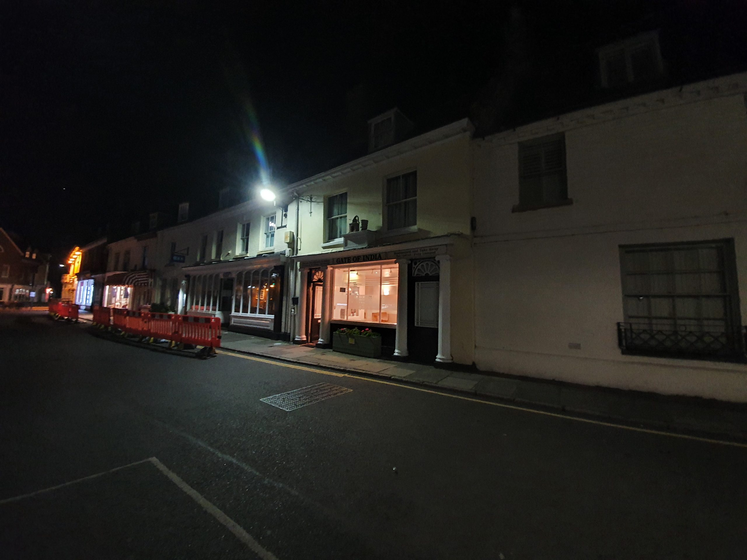
    I’ve certainly had my fair share of discounts from the Government’s ‘eat out to help out’ and this was the last meal of the month, on Monday 31 August 2020. Richard and I had been meandering around some churches in North Norfolk and this was one of the few food options available to us, since we hadn’t bothered to book anything (or more precisely, most places we wanted to book at the last minute were full).

    The menu at the Gate of India in Aylsham.

    I have to temper my expectations here a little, I wasn’t back in India (which I miss very much) and I wasn’t at the on-trend Indian restaurants in London that I’ve been fortunate enough to try recently. As poppadoms and chutneys go, these were OK but weren’t particularly inventive or exciting. The drinks were also expensive, a pint of Coke was £3.75 and I’m not exactly sure what brand they were using.

    The Peshwari naan bread was again OK, but lacking in any depth of flavour and they were reliant on some sort of paste that didn’t have any texture. That’s the chicken biryani, again lacking any particular depth of flavour, although the chicken was well cooked and tender. There was some texture to the rice, with everything properly cooked and at the appropriate temperature, but it needed something more exotic in terms of the taste.

    This came with the biryani, again lacking any depth of flavour, which is not entirely usual for an Indian restaurant or any variation thereof.

    Service was efficient if not engaging, but it was timely and we were never left waiting. I was, shall we say, surprised that the restaurant forgot to apply the ‘eat out to help out’ 50% discount. The bill was though immediately corrected and I can’t much complain here because mine came to £10 after the discount was applied and I paid using Amex and shop small kicked in, meaning that I paid £5 for the entire evening’s food and drink. For that price, I was entirely happy, so this proved to be a marvellous choice for Richard and me.

    I’m not sure that there was anything exceptional enough for me to want to return though. The restaurant is reasonably well-reviewed (although not quite as good on TripAdvisor), somewhere in the middle of restaurants in the area, and so I don’t think there’s anything particularly bad, but perhaps standards in Indian cuisine have just moved so much in the last couple of years that there are better options out there.

  • Cromer – Sunset Photos

    Cromer – Sunset Photos

    Just photos…. From Bank Holiday Monday evening in Cromer.

  • Paston – St. Margaret’s Church (Chest)

    Paston – St. Margaret’s Church (Chest)

    Most churches would have had a chest, or hutch, such as this in order to store their parish documents and any valuables. Not many survive in situ, so this is quite marvellous, with this one dating back at least 600 years. Fortunately, the documents, which date back to 1538, have now been moved to the wonderful Norfolk Record Office, so they’re safe and sound.

    Unfortunately, the current health issue means that it has red and white tape attached to it to try and keep visitors in limited areas, but this is all now part of the long history of this chest. That this chest has survived for 600 years, with no-one pinching it or damaging it, is remarkable, as is that it has never been caught up in a fire or other disaster. A rather lovely item to see.

  • Paston – St. Margaret’s Church (It’s All the Wrong Way Round)

    Paston – St. Margaret’s Church (It’s All the Wrong Way Round)

    It’s fair to say that Richard and I are not church experts, although we’re getting ever more competent at this church history thing now on our meanders. But, it was evident to me that we were approaching the church from the wrong side and it was evident to Richard that the lychgate was in the wrong place.

    This lychgate should be where the road is, not in a random corner.

    The church itself addresses this issue on their web-site:

    “You approach the church from the north, the “wrong” side, because the first Sir William Paston in the early 15th century diverted the road away from Paston Hall to reduce disturbance to himself and his family This angered the villagers who demolished the wall he had built across the old road, which he then re-built and the family had insults hurled at them (all of which is described in the letters).”

    Which all leads me to want to look at maps, although of course, the changes in the fifteenth century mean there won’t be much evident here.

    So, this is the starting point (clicking on the image makes it bigger), which is the church in 1900 on the left and the church now on the right.

    This is the tithe map, which gives a faint clue. We know that the road went to the south of the church and that the wooded area is the boundary of the church, so the road must have cut straight across the area in front of Paston Hall (just to the top of the blue circle and there’s a route of a former footpath evident through there) which is what inconvenienced Sir William.

    I can see why the locals were annoyed…..

  • Knapton – St. Peter and St. Paul’s Church (War Memorial)

    Knapton – St. Peter and St. Paul’s Church (War Memorial)

    This war memorial is located in front of the village’s church and was installed here in 1919. There was a grant of £273 provided for by the War Memorials Trust in 2010, which was used to clean up the lead lettering which had become hard to read.

    There are seven names on the war memorial from the First World War:

    Tom Colin Barcham

    Percy William Swann

    George Turner

    Douglas Lambert

    Albert John Mace

    George Wild

    Robert Christmas Yaxley

    Another three names were added to the side of the memorial following the end of the Second World War:

    Frederick Watts

    Thomas BB Wood

    Sydney E Woollsey

  • Knapton – St. Peter and St. Paul’s Church (James Riesbrow)

    Knapton – St. Peter and St. Paul’s Church (James Riesbrow)

    It took me a little while to work out this name, but it’s the grave of James Riesbrow, located in Knapton’s church. It’s such a rare name that this is the only person I can find in the country over the last few centuries with that name, which makes tracking him down that bit easier.

    James was married to Mary Means at the church on 14 October 1759 and the ceremony was witnessed by Charles Coleby and James Downing. It’s clear the clerk was confused by the name as well, trying to originally spell it as Riesborough. James died at the age of 48 on 7 June 1778 and I note that someone with the same surname was buried at the church in 2018, so the name has continued on.

    There aren’t that many graves from the late 1700s that remain in Norfolk’s churchyards, particularly not in this good a condition.

  • Knapton – St. Peter and St. Paul’s Church

    Knapton – St. Peter and St. Paul’s Church

    As part of our church spotting evening (yes, I know, churches aren’t that hard to spot in the scheme of things), Richard noted this one which is St. Peter and St. Paul’s Church in Knapton.

    The current building (including the tower) primarily dates to the early fourteenth century, although there was likely a church on the same site before this. As an aside, apparently the tower’s weather-vane was designed by John Sell Cotman.

    I don’t know why the Priest’s door has its own little porch and I’m not sure that picket gate arrangement does much for it either. I have no idea how old it is, but it looks like something that the Victorians would have done. The church was modernised by the Victorians (overseen by George Gilbert Scott) and there was a re-opening ceremony on 7 September 1883, with an advert in the Eastern Daily Press providing details of what trains or omnibuses people could catch.

    Visible here is that the church tower is off-centre, which isn’t a usual arrangement. But, I’ve learned something new by reading the description of this church at Norfolk Heritage, which notes:

    “The odd position of the tower was not the result of a change of plan but clearly deliberate from the first as demonstrated by the straight joint on the north wall close to the tower showing that provision for the tower was made. The slightly later building of the tower was separated from the nave at first – a practice commonly observed in other medieval churches where towers took long to build and tended to settle at a different rate from the nave.”

    I hadn’t realised that this was a thing, but building the tower and nave separately does make sense, although I’m still unsure quite why it’s off-centre.

    The porch, so near to the treasures within and one of the most important roofs in the country apparently, dating to the beginning of the sixteenth century.

    Alas, the church seems to be rather nervous about opening up for 72 hours before a service and 72 hours after a service. Seems a bit much to me, but there we go, there’s always another day to see what is apparently a glorious interior. The roof has been a problem in recent decades, with an expensive restoration having just been completed at the church. The church authorities have had problems with death-watch beetles throughout much of the early twentieth century as well, proving to be an expensive pest to remove.

    The churchyard is curious, there are a couple of eighteenth-century graves in noticeably good condition, which I assume is simply because a different stone was used, but nonetheless. There are also large gaps in the churchyard where graves must have been, but there is an absence of gravestones in some areas.

    Back to this photo again, we deliberately tried to find the spot where George Plunkett stood to take his photo (in 1993, so this was a later one). His photo is here, so I think that our effort was creditable…..

  • London – Lambeth – Imperial War Museum (Air Raid Damage in Norwich)

    London – Lambeth – Imperial War Museum (Air Raid Damage in Norwich)

    From the collections of the Imperial War Museum (© IWM HU 140004), I’ve never seen this photo before. There’s no address on it, but it was taken in Norwich following a Baedeker Raid which took place on 29 April 1942. The man was the owner of the shoe shop which had been destroyed, looking through to see if he could salvage any of his stock.

  • London – Lambeth – Imperial War Museum (Troops on Sheringham Beach)

    London – Lambeth – Imperial War Museum (Troops on Sheringham Beach)

    And my last photo (for today at least) from the Imperial War Museum archive (© IWM H 11689), this is a photograph of Sheringham beach which was taken on 12 July 1941 by Captain Len Puttnam. The military had allowed the public to access the beach, but they were present to ensure that they didn’t stray too far, with the men of 2/5th Battalion of the West Yorkshire Regiment overseeing proceedings.

  • Mulbarton – Spong Lane

    Mulbarton – Spong Lane

    We walked along this lane on the 18-mile walk I led around Mulbarton last week and it was a word I liked, but didn’t understand the origin of. Anyway, after checking I have discovered that a ‘spong’ is a long and narrow piece of land, or an irregularly shaped piece of land. You learn something every day….. Well, most days.