I have a slight problem at the moment with rail travel and that’s trying to keep the fares down whilst I’m travelling around the country. I’m simultaneously too young and too old to have a railcard and the fares can be challenging without using some ingenuity of split ticketing. I’ve also been hitting delay repay claims with some frequency recently and have had three turned down or refunded at a different amount, but all three fully reinstated on appeal due to ‘operator error’ or similar phrases. They don’t really have much choice as the Conditions of Carriage are very clear and it’s a bit of a faff, but we get there in the end.
So, mostly for my own amusement, here’s the story of today and endless changes of trains….. It’s actually evident to see why rail operators are struggling to unpick some of these delay repay claims and today’s will be another one when East Midlands Railways get it this weekend.

That’s not a great photo of Liverpool Lime Street, although I was taking photos to remind me at what time I was at each station. Half of the station has gate lines, the other half doesn’t and this was one of those tracks, track 6. Incidentally, on the way into Liverpool, we stopped at Broad Green railway station and I looked at the station history on Wikipedia (yes, I do this a lot) and discovered that it’s the oldest railway station in the world that is still operating, having opened in 1830. On that theme, Liverpool Lime Street is the oldest still operating grand terminus mainline station in the world, opening in August 1836.

The first train of the day was on time, the 10:08 West Midlands Train service to Crewe.

I liked this train, relatively empty and there were power points which are useful for journeys such as this. There was a passenger on board telling his friend Tony (he said the word Tony at the end of every sentence so I soon got to know Tony’s name) who gave a near constant verbal flow of railway facts on our journey. To be honest, I found it all quite interesting, so fair play.

Crewe, it’s not my favourite place in the world if I’m being honest, but I wasn’t leaving the railway station and so it didn’t much matter.

Here’s the EMR train service to Long Eaton.

More power points and an annoying customer who was playing music loudly sitting opposite. I’m generally quite immune to these things, but when it’s so loud it’s over the volume of my headphones, it probably is a bit much. Someone else sat opposite and stared at him, which meant he later on stopped, so that was a relief for us all.

Only here briefly, but a quick photo at Stoke railway station to send to Łukasz who sometimes meets me here. The train was delayed into Long Eaton, but this didn’t much matter as the one I needed to connect to was also late and was coming in on the same platform.

Long Eaton railway station which was opened in December 1888 as Sawley Junction.

An information board about Midland Railway Sheet Stores.

Right, I can still get the 12:40 because it’s going at 12:46.

Here it comes sweeping in to take me to Leicester.

And there’s Leicester in all its raw beauty and there’s been a railway station on this site since 1840.

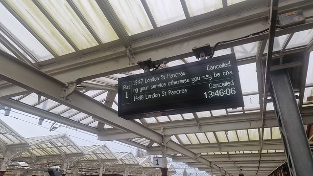
This train into Leicester was busy and I couldn’t get photos inside and it was running fifteen minutes late, meaning I’d miss my connection. But, as luck would have it, the train I was connecting to was once again also late and coming in on the same platform. I boarded three different trains today that had an end destination of London St Pancras and all three had the seat reservations cancelled as the on-board computers had gone wrong.

I boarded the East Midlands train to Kettering and it was at this point that the network was entirely falling apart due to electrical cabling issues. There weren’t really enough staff to help at Kettering and no announcements to help passengers at the station, it wasn’t great for those who didn’t know their way around railway apps and the like.

I went to find someone (not pictured above) and she told me which train to connect, telling me to get on a train to Bedford.

I had a little walk around Kettering railway station which was originally opened in 1857. I find it very hard to be in Kettering and not think about James Acaster and the Kettering Town FC song. Incidentally, that bridge to the other platforms was only put in as late as the 1990s.

This is a nice reminder of how railway stations have been such important locations in times of war.

And here’s the canteen that it’s referring to. There are an awful lot of structures on railway stations, it’s a shame that more can’t be done with a great deal more of them, although at least this one hasn’t been demolished.

Aaaahh….

Another train boarded, this is the one to St. Pancras yet again. I was fortunate incidentally to get a seat on every service despite them being so busy. Most trains had power points and customers seemed to be generally calm and content.

And safely at Bedford. I thought it was positive that the train guard told anyone with flights from Luton Airport that they were fearing they’d miss to tell the platform staff so that they could do something about it. I’m not sure what the platform staff were planning to do about it (and even if they knew the train guard had been telling passengers this), but it was a nice gesture.
For reasons unknown even to me, I’ve started noting in this blog post when railway stations were first opened, so keeping that theme alive, this opened in 1859 although it’s moved about a bit. When I say that, I mean it’s moved down the line a bit, they haven’t relocated Bedford railway station from Truro or something.

I waited patiently here for the Thameslink train I was told that I could catch as they were accepting EMR tickets given the network issues. Of course, it changed its departure platform which involved more stairs. This is how I stay healthy I think.

But, it arrived on time and took me to Luton railway station and incredibly the only service of the day actually running to schedule. I arrived into Luton just under 50 minutes later, so that’s a 50% delay repay of the ticket and I thought I did well to actually get to the final destination not that late.
I am perhaps one of the few people who likes this kind of adventure, I’ve also been suitably productive working on trains and also in numerous waiting rooms that I didn’t take photos of today. And now, I’m safely in Luton. I can’t say that this is exactly a Michael Portillo Great Rail Journeys type of post, but it amused me and maybe in my old age I’ll relive the excitement all over again and return some fancy destinations as Crewe, Long Eaton, Kettering and Bedford. Incidentally, I should add, there are more direct ways of getting from Liverpool to Luton, this was just the cheapest one for me, even if not the most convenient.