
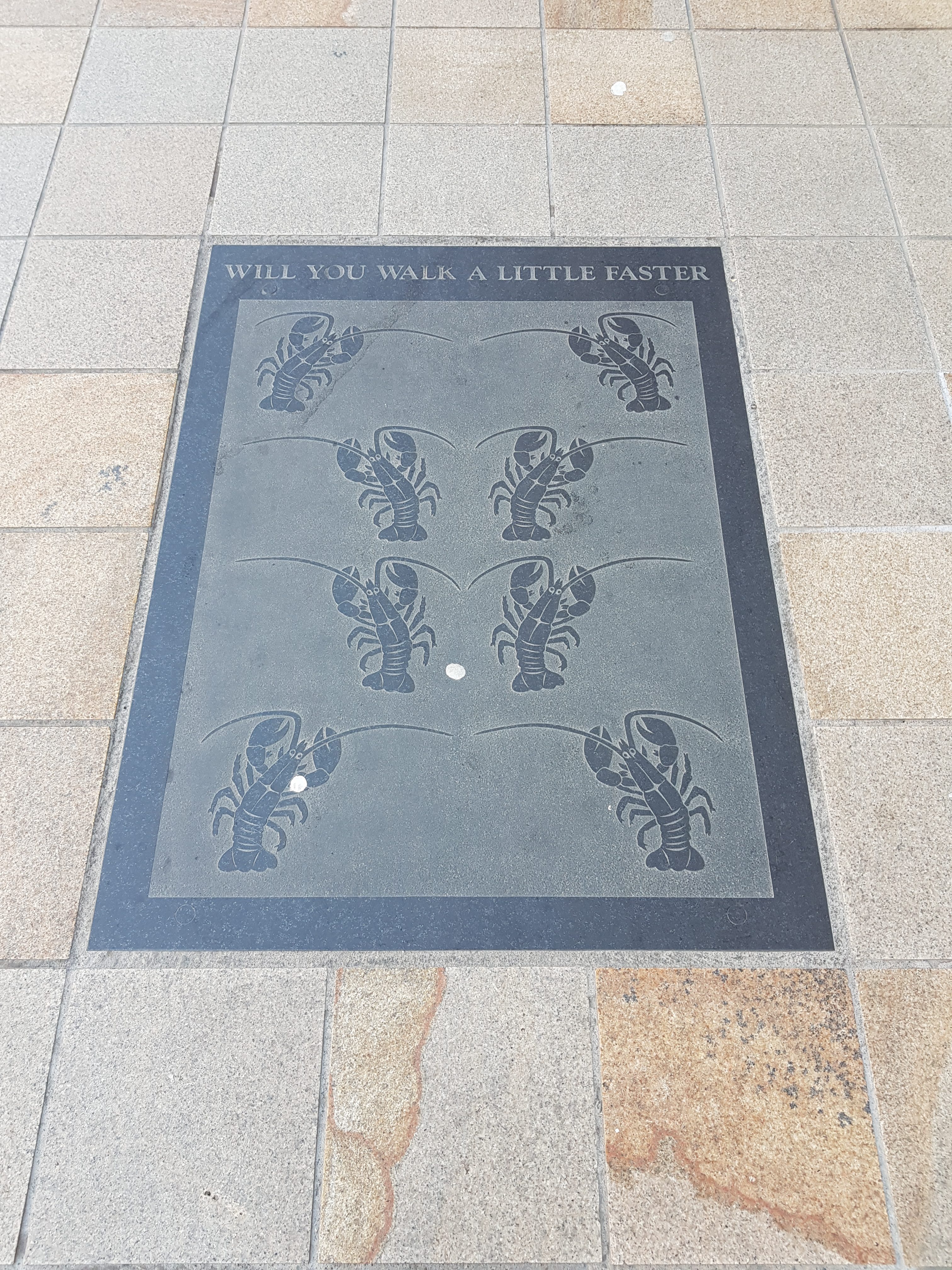
I think this in my mind a lot of times during the day about someone walking in front of me…..
Author: admin
-
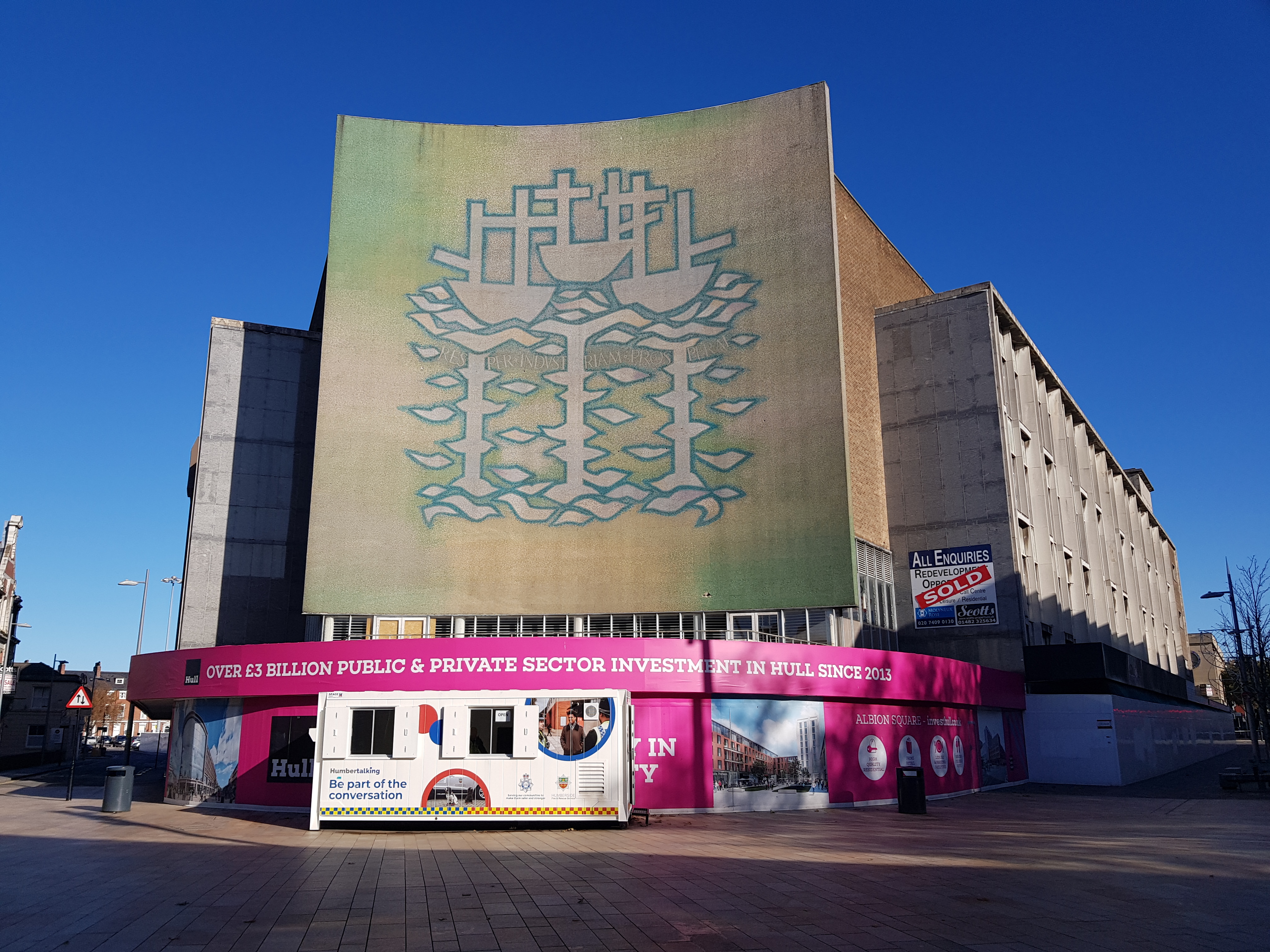
Hull – Three Ships Mural
It looks like the end for the Three Ships mural in Hull, which the city council has said can be demolished. It’s a clever design, spelling out the word Hull and also focusing on the city’s maritime heritage. There are a quite staggering one million pieces of glass in the mural, which was designed by Alan Boyson in 1963 for what was then the Co-op building.
It’s the largest such mural in the country and there is currently a petition to save it, with a separate letter being signed by Sir Tom Courtenay, Al Murray, Kate Fox, Bob Stanley and Kevin McCloud. The Co-op were later replaced by BHS, but their demise has seen the building left empty and the site is now earmarked to be used for the £130 million Albion Square redevelopment.
The council is claiming that the mural can’t be saved because there is asbestos in the building and they said that HSE wouldn’t let them separate the mural from the wall. I’m not sure why the HSE wouldn’t let this happen if appropriate safety procedures were followed, but it doesn’t look very positive for this wonderful mural.
-
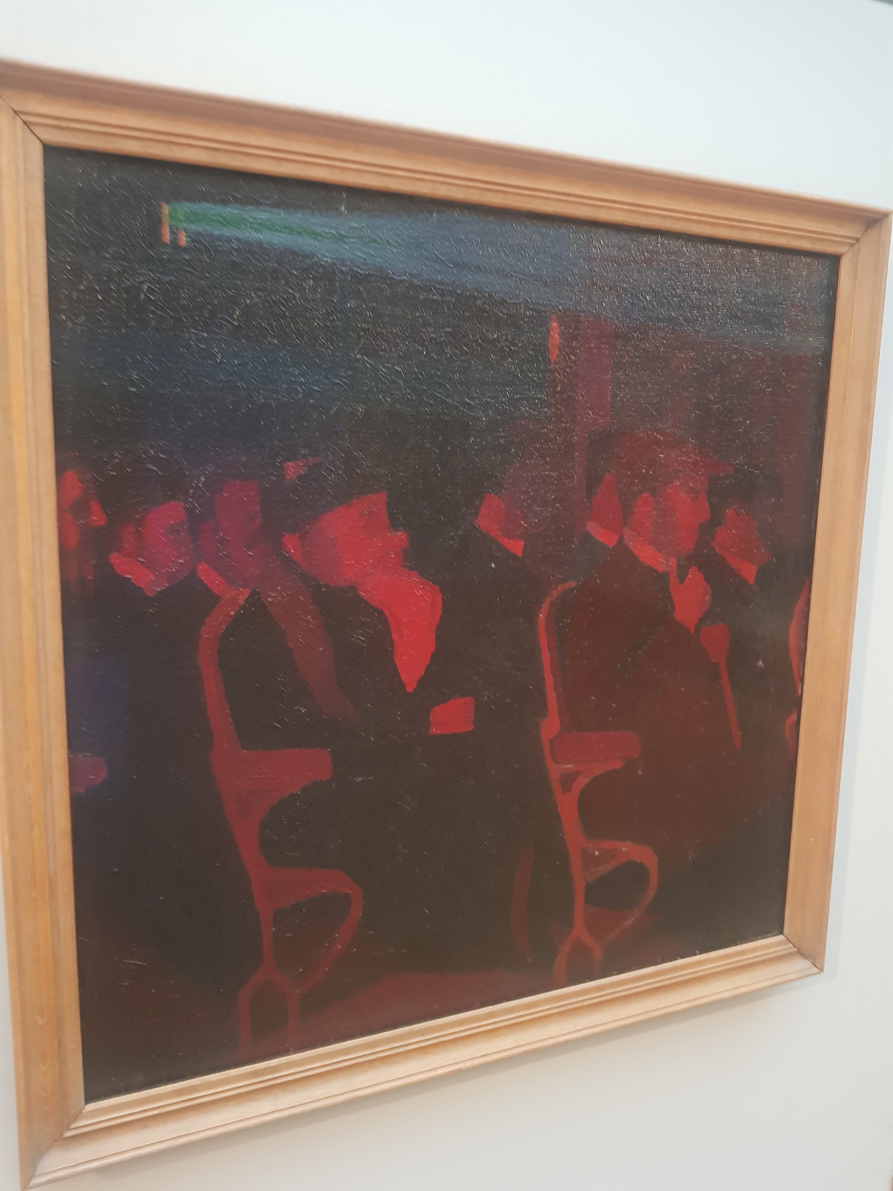
Hull – Ferens Art Gallery (In the Cinema by Malcolm Drummond)
This artwork was painted in 1913 and so it is a relatively early depiction of a visit to the cinema, not a subject that I’ve seen portrayed like this before. A dark cinema doesn’t seem to be the most obvious thing to show, but it’s quite evocative, a bit Lowry in terms of the working person being anonymously portrayed.
The Ferens Art Gallery purchased the artwork in 1969 and the Guinness Movie Facts book claims that this is the first painting known in existence of an audience watching a film inside a cinema.
-
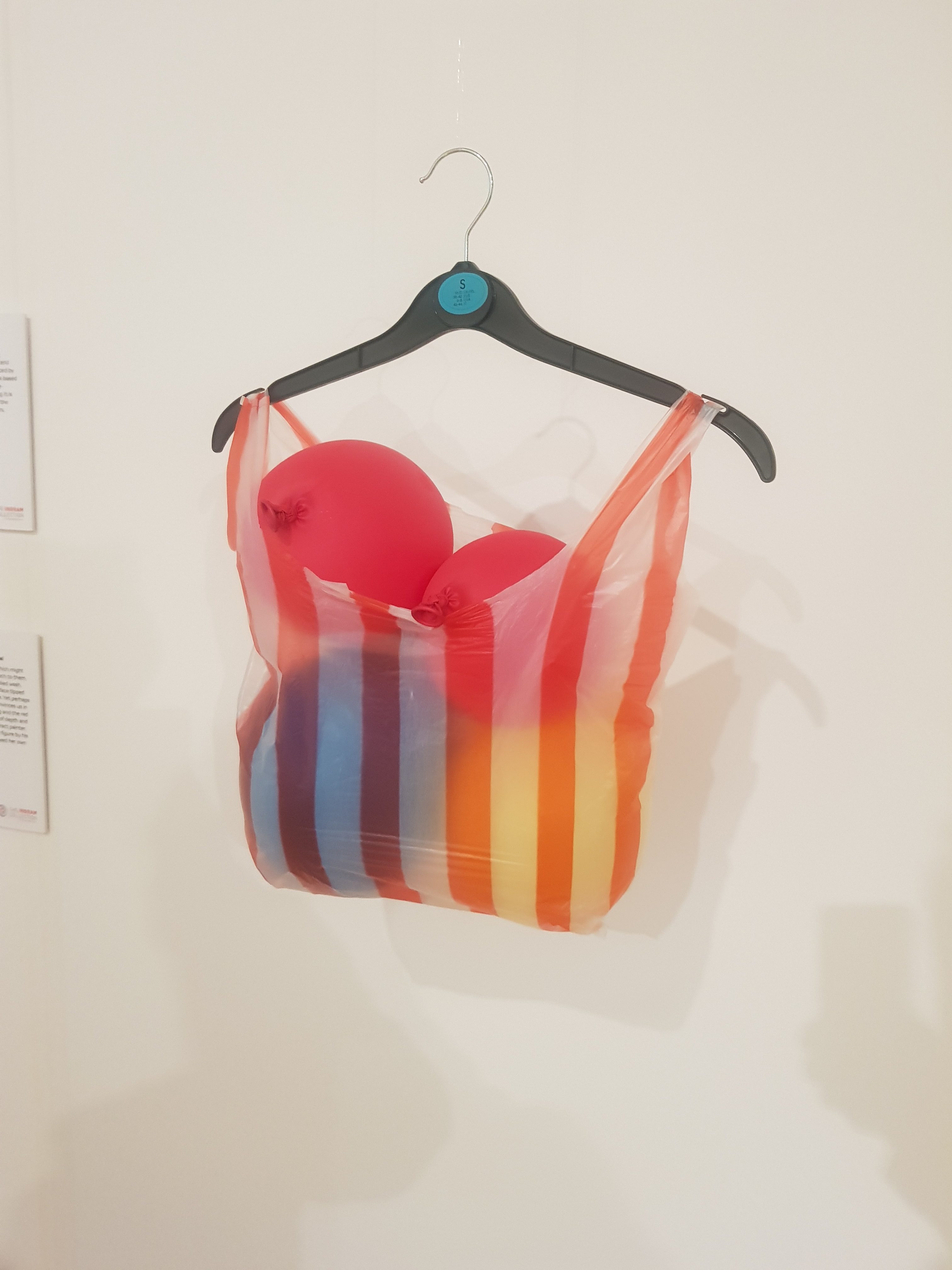
Hull – Ferens Art Gallery (Fun Bag by Victoria Sin)
Not being the sharpest knife in the drawer at times, I don’t always get what modern art, or indeed other mediums such as performance art, is trying to tell me. So, it’s helpful to have the gallery provide some context and meaning to an artwork.
And, I quote:
“Here they combine everyday objects to create a work that questions the representation of women in the media”.
OK, I’m not quite getting that message, but it’s an important one and I like it. But, this artwork had somewhat perkier balloons at one stage, so I’m guessing that the artist is trying to suggest that the slow withering away of the balloons is equivalent to the challenges which females have when they age.
But it probably means something else, and judging from what others have written about it, I’m confident that it does and it’s something wider about sexuality. However, since it made me think, that’s a win for the artwork….. And there’s one nice element about art, everyone can have their own interpretations of works, even though mine are usually wrong.
-
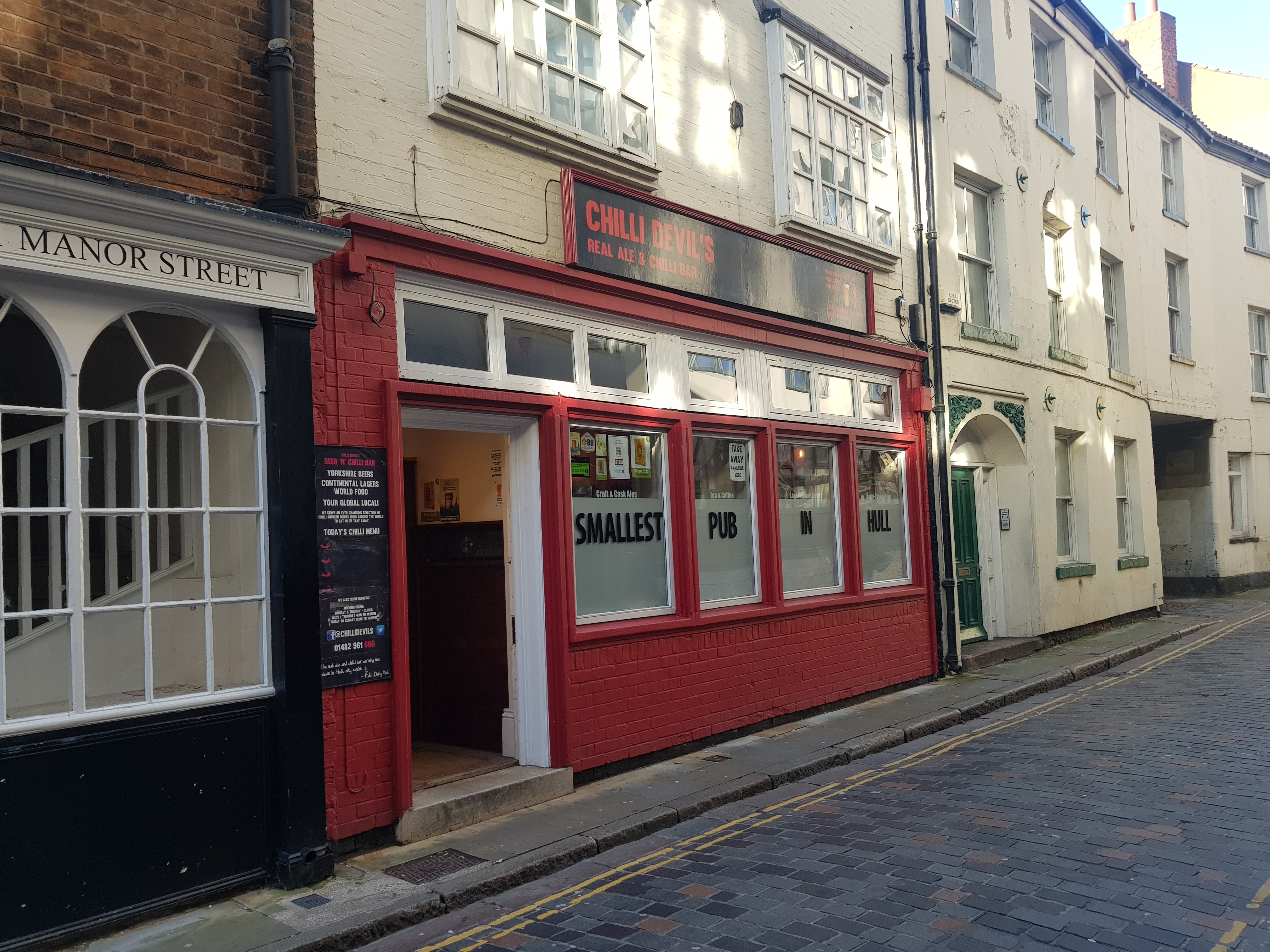
Hull – Chilli Devil’s Real Ale and Chilli Bar
I’m really not sure that I’ve ever visited a pub, or indeed restaurant, that specialises in craft beer and chillis. But I think that this is a great idea, and I strongly approve. This pub is in the Good Beer Guide and, as the advertising on their window suggests, it’s also the smallest pub in Hull, so I wanted to get there early when I knew that I could get a seat.

I didn’t have any problems getting a seat and I was the only customer for the entirety of my visit. Still, friendly staff member and there’s a nice vibe to the place, although I’m sure it’s all a bit more charming in terms of the atmosphere later on in the day.

They weren’t selling any chilli dishes when I was there, although I knew that before I went in as they chalk up the options on a board outside (and they actually chalk up the options above the bar, and I’ve just noticed they do have one up here, which I missed at the time). If there was definitely a chilli available, I might well have been tempted though. Although, the pub doesn’t accept credit or debit cards, which is a marginally surprising decision as I’ve seen very few pubs stick rigidly to this. To be fair, they make this clear outside and inside, so no-one would be surprised. And it made no difference to me, since I was always intending to pay with cash.

Now, this was very lovely indeed, the Tonkoko Milk Stout. Very rich, creamy, coconuty and the strong flavours which I like. I was very tempted to get another half pint of it, but I had more pubs to visit in the city, but it’s one of the best beers I’ve had in a while.
All in all, a really charming little pub, and another deserved entrant into the Good Beer Guide. The local CAMRA group really haven’t let me down this week.
-
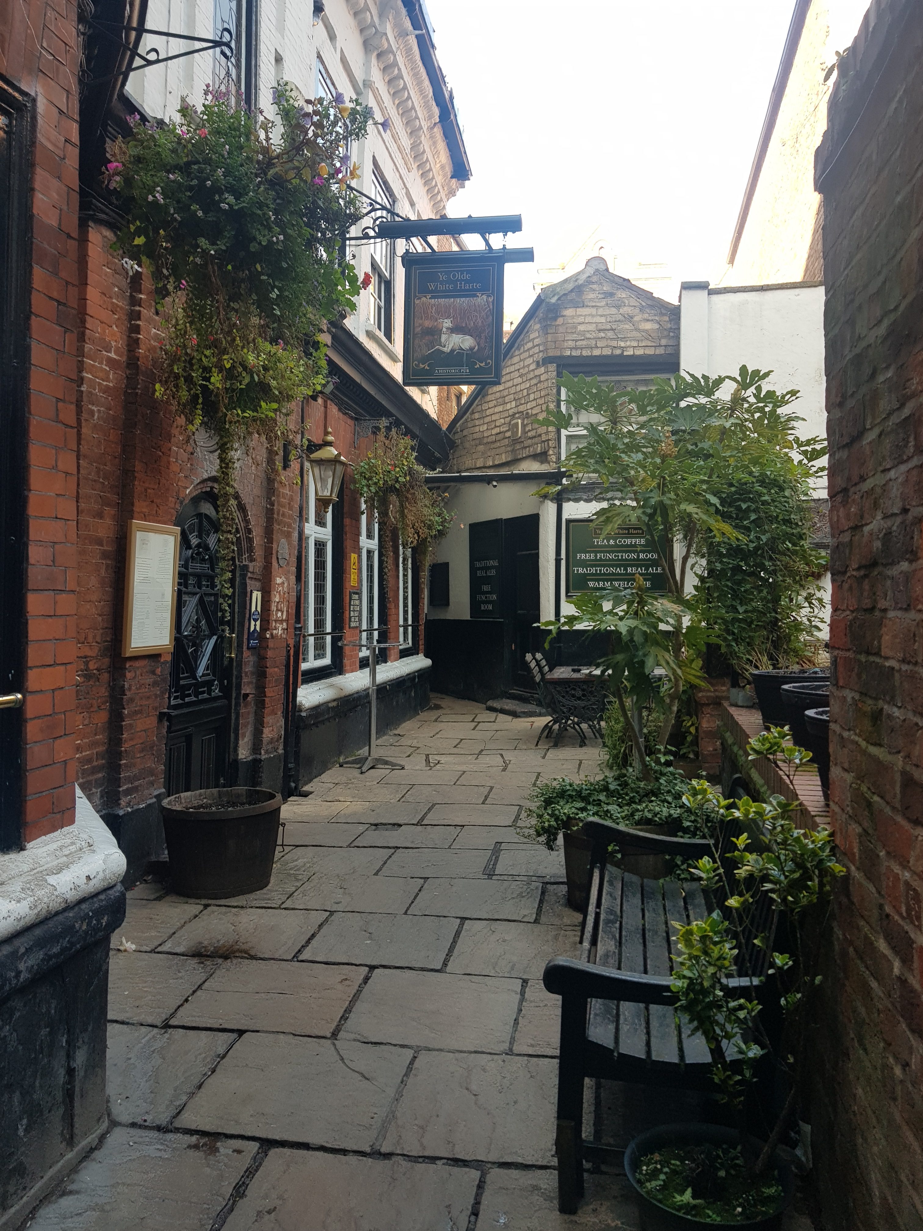
Hull – Ye Olde White Hart
I’m running out of time in Hull, so I’m making a renewed effort to get through all of the CAMRA Good Beer Guide pubs in the city centre.

This pub is packed with history and is located down an alley in its own courtyard, which some of the best historic pubs are. There are some stories about this pub, including that it was where the meeting was held where it was decided that King Charles I would be refused entrance at the Beverley Gate in the city. The building was then a private residential property and looking at the listed building description, those dates don’t really quite match up. But, this was indeed a late seventeenth century property and so it’s interesting solely for that.
It became a pub, or at least was heavily remodelled into a pub, in 1871 and there are four main rooms, two up and two down. The downstairs two both have large fireplaces and do have a lot of character, being pretty much unchanged in design (although not the bars themselves which are more modern) since they were installed. Looking at some of the local press in 1877, the pub owners advertised the opening of the “King Charles’s Room” and the “Plotting Parlour”, so this is where the myth appears to have started. They also advertised that they provided “solid and liquid refreshments” and they mentioned they had 1,000 cigars in stock, and the pub was also at the time a hotel as well.

Nothing exceptionally exciting was available in terms of the real ales, but I’m always happy to have Theakston’s Old Peculier and this was well kept and tasted as it should. Service was OK, but the barman had that very mildly irritating habit of returning my change whilst talking and facing the next customer. Nothing says “sod off” better than that that in a pub which isn’t even busy. Well, there are quite a few things which would be ruder, but at least a pretend thank you would be nice. I think the Hop and Vine yesterday has raised my expectations…..

One of the two downstairs rooms, this is the one by the main bar. Very atmospheric and quite dark, although that suits the pub nicely (I mean because it fits in with the decor, not because it’s sinister). Some of the beams in the pub apparently have burn marks on from a fire which broke out in 1883. However, it was so dark I had no chance of making that out.

Does the pub really need that AWP there? I’m not sure it’s entirely in keeping with the rest of the interior.

The fireplace is more in keeping and there’s one in the other room as well.

There was limited seating available, so I went to sit by the second bar in a corner. This bar slightly annoyed me, it seemed entirely pointless and of limited historic integrity. I didn’t think much more about that until reading that the pub themselves wanted to get rid of it, but there was local opposition so they weren’t allowed to. It seems like a waste of space to me, I can imagine the pub managers weren’t thrilled being told that they had to leave it in situ.

It’s a bit difficult to tell given the Halloween decorations, but the pub is known for having the skull of a younger person on display. It’s encased to protect it and can be seen in the middle of this photo. I’m really not sure it’s very dignified to put a Strongbow Carnevil promotion top of a real skull, that’s quite tacky. Although, I suppose, if you’re putting a skull on display that you’ve found in the pub then the bar has already been lowered.

An animal head with Halloween decoration. I’m sure that the pub probably is haunted, as it certainly has enough heritage to deserve its own ghost, and they do have paranormal investigations here.
The pub is very well reviewed and it’s history mean that it’s worth popping in for a quick drink. Or, for that matter, a slow drink.
-
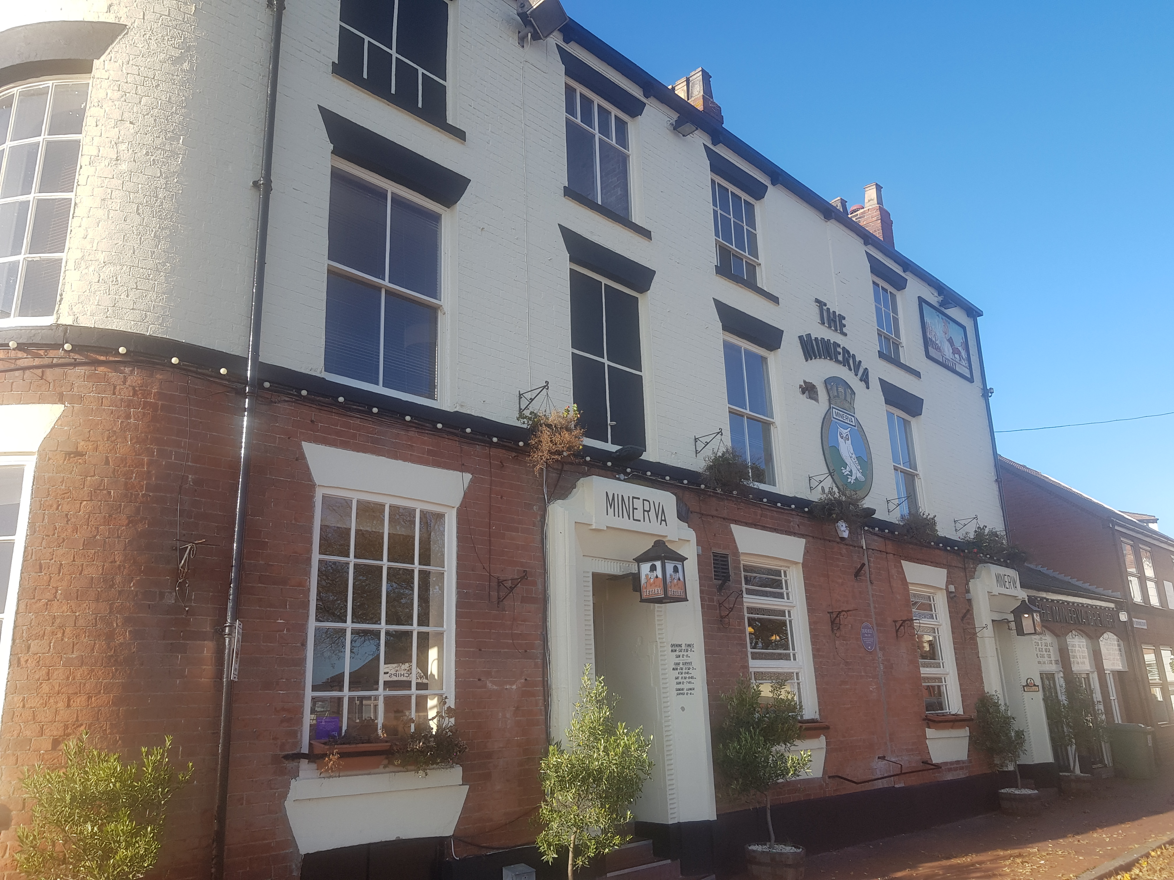
Hull – Minerva
And carrying on my tour of Hull pubs which are listed in the Good Beer Guide, the Minerva is located by the old docks area of the city. There was quite a vibrant feel (I sometime use that word to subtly suggest that there was a riot taking place, but in this instance, it was relaxed and lively) in that area of the city, somewhere that I haven’t been before.

My first impressions were very positive, as I had hoped to get food and beer, but they looked full so I was planning to move on. However, a staff member was more than keen to assist and she found me a table that I could have for 90 minutes to myself. Although this transpired to be a table for 14 people, it more than met my needs. I sat towards one end, but on reflection I should have perhaps sat in the middle and tried to look important. The reason for seating me here was that they had the 14 people arriving around 90 minutes later, so I had a marginally limited window of time, although I was nowhere near to needing that long.
Anyway, that welcome is also wonderful, as a pub doesn’t know why someone might be visiting on their own. They might just be on a seemingly endless tour of British pubs (oops….) or they might have made a real effort to go out so they weren’t on their own. Some pubs deal with this really badly, their set-up isn’t designed for single visitors and they don’t make it particularly easy. This pub managed to offer the perfect welcome and this sort of effort makes it much easier to encourage single diners and drinkers out, with Wetherspoons and Greene King now having apps to order at the table also making the process a little less stressful.


I nearly added this pub to my list of the best of the year, but this beer selection just isn’t really relevant to me. They’ve got six ales on, which are all light and some of them are quite generic. They’ve lined up six sample jars in front of the pumps and I was struggling to see much difference in the colour of any of them. They did have Tetley’s best bitter on, which I’m quite partial to, and it’s the only permanent fixture here, but I was hoping for something a little different.

There’s the only real option open to me, Marston’s Oyster Stout, and I do like the taste of this, smooth but with a taste of molasses or something similar. But, the temperature of the beer was a little cold for my liking, that was served at a chiller temperature rather than cellar temperature, and I prefer the latter. That reminds me of when a rep came to a pub I had many years ago and told me how excited they were about the new trend of extra cold beers. He then admitted that the extra cold version of his beer was proving very popular, but they themselves thought it tasted of nearly nothing as the taste had been knocked out by the extra chilled temperature. That wasn’t a problem here, but it’s why I was a little disappointed there wasn’t something more interesting in the real ale section.

The fish and chips, which was well presented and the portion size was more than adequate. The tartare sauce was homemade and is one of the best I’ve had, it had what I think were large pieces of gherkin in and it was creamy and very moreish. The fish batter could have perhaps been drained just a little more, but it was flavoursome and the fish flaked away nicely. The chips were again home-made and the mushy peas actually tasted of peas, which is something I’ve yet to have in a Greene King pub, where I’ve wondered what they make their peas from. I think it’s flour mixed with green paint and water. Anyway, I shouldn’t be mentioning Greene King, that’s twice in one blog post.
CAMRA mention that this pub is owned by the city council and it was built on reclaimed land in 1829. I saw the smallest pub room in the country, which is really just a small snug which can only hold a couple of people. I couldn’t really take a photo as there were two people in there eating, although I suppose I could have done a a walk-by photo and hoped they didn’t notice. Not really good to invade privacy that much, but it was a fun little part of the pub. And apparently, although I didn’t see it, they’ve got a theatre and brewery area to the side of the pub.
Anyway, I thought that this pub was excellent, and the staff were all customer service orientated, including the serving staff and those behind the bar. Customers were served in turn, the staff were friendly and the serving staff made a big effort to find me a table. I could have done with a better selection of real ale, which seems a bizarre comment for somewhere that serves six different ones, as then I could have elevated the pub into exceptional status. As it was, it was just excellent, so all very lovely.
-
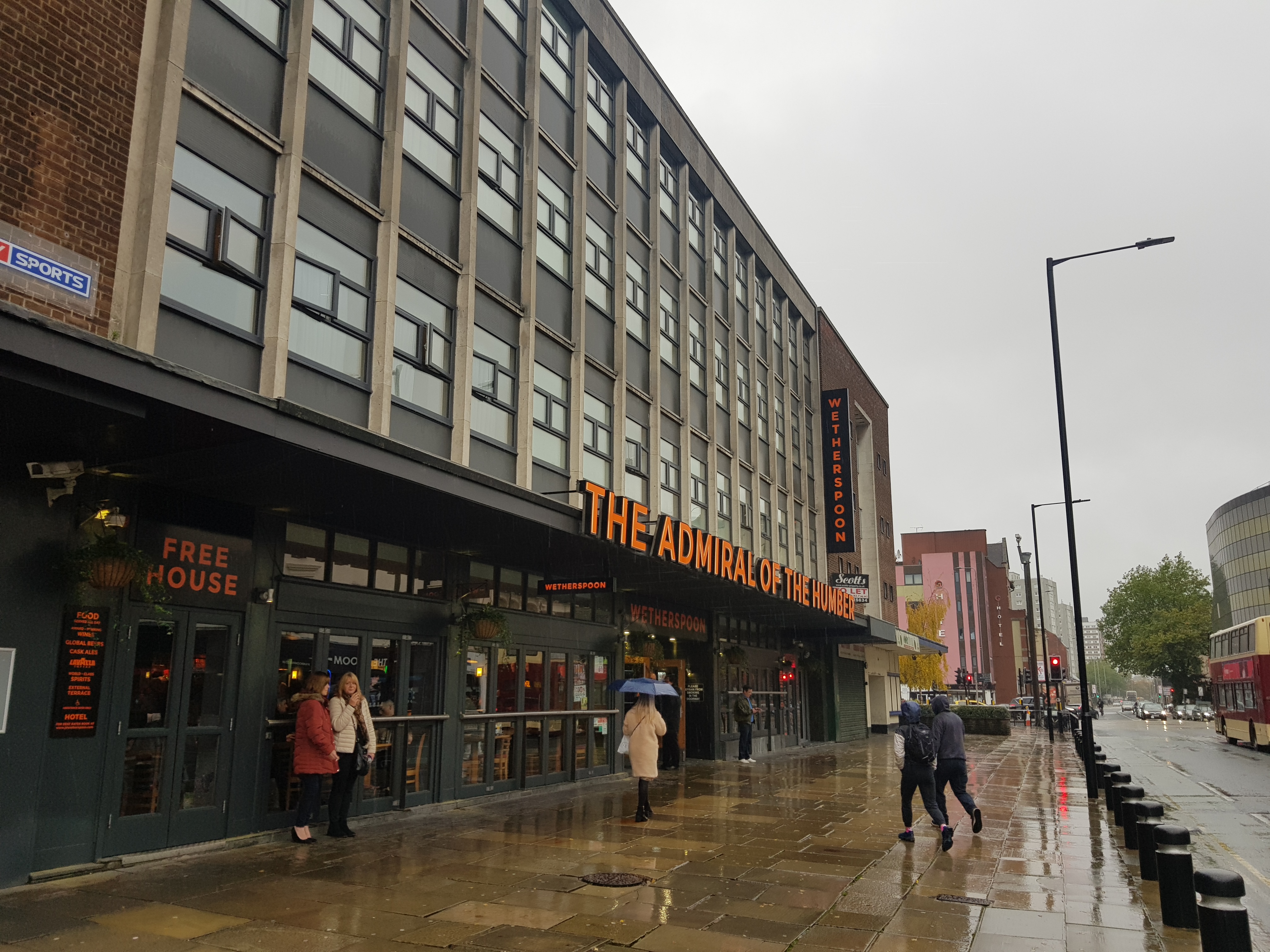
Hull – Admiral of the Humber
Along with the Three John Scotts, this is one of the two remaining Wetherspoons in Hull, since two have been sold off. It’s named after a former official job title dating back to 1447 and although it is just an honorary role now, the city’s Lord Mayor remains the Admiral of the Humber.

My visit was at 10am, so I didn’t opt for a beer, but their selection was acceptable and, as usual, reasonably priced. Service was fine and I didn’t have long to wait, even though there was a bit of a queue at the bar.

I had a coffee moment. Several coffees actually, so I sat in a location which was convenient for the coffee machine.

It was raining outside, so the fire was handy to warm up a little, although to be fair, I’m hardly ever cold so it doesn’t much matter. The pub has been modernised recently and there are now hotel rooms above the pub. Wetherspoons don’t seem to have enough capacity now for the number of customers they have as this pub was full this morning soon after I arrived and I noticed a few customers leaving, solely because they couldn’t find anywhere to sit.

A stag group who had started drinking early, off I guess to the railway station after their visit.
I am amused by a review posted today on TripAdvisor about this pub, complaining that the staff were watering down the Magners as it didn’t taste of anything. The pub staff would be talented to water down a keg cider, but I do agree that Magners doesn’t ever taste of anything much, especially with their brand obsession of putting ice in the drink. The same customer then complained that the staff watered down her vodka and coke….. I can imagine the delight of the duty manager dealing with that.
Anyway, there’s not much I can add about this pub, although it is in the Good Beer Guide which is a positive achievement. It’s all a bit generic and soulless given the building isn’t of much interest, but there’s not really anything wrong with the value offered and the variety of real ales and craft beers.
-

Hull – Central Library Book Sale
I visited Hull central library yesterday and mentioned that they had a book sale on which started today. I told myself I wouldn’t go as I didn’t need any more books, but like some demented homing pigeon, I found myself there by two in the afternoon. To be fair, I’m surprised that I lasted so long.
I’m a little disappointed in the library service as well, as they were discarding books for £1 that had been in the collection for over 125 years. They were primarily from the music library where the librarian must have decided they didn’t need such heritage on their shelves, but it’s a loss to the collection that seems unnecessary for the small return they’d get. Most of the books were though more recent, but even so, I have no idea why so many are being discarded.

I promised myself that I’d only buy one book, even though I had a feeling some books were worth a fair chunk more than the £1 that was being charged. So, I got myself this, one of my favourite series of books and they’re challenging to find, although libraries usually have their local book. These aren’t easy to locate and it’d probably sell for £5 or more, but for the moment it can fit onto one of my book-shelves. I can find space.
-
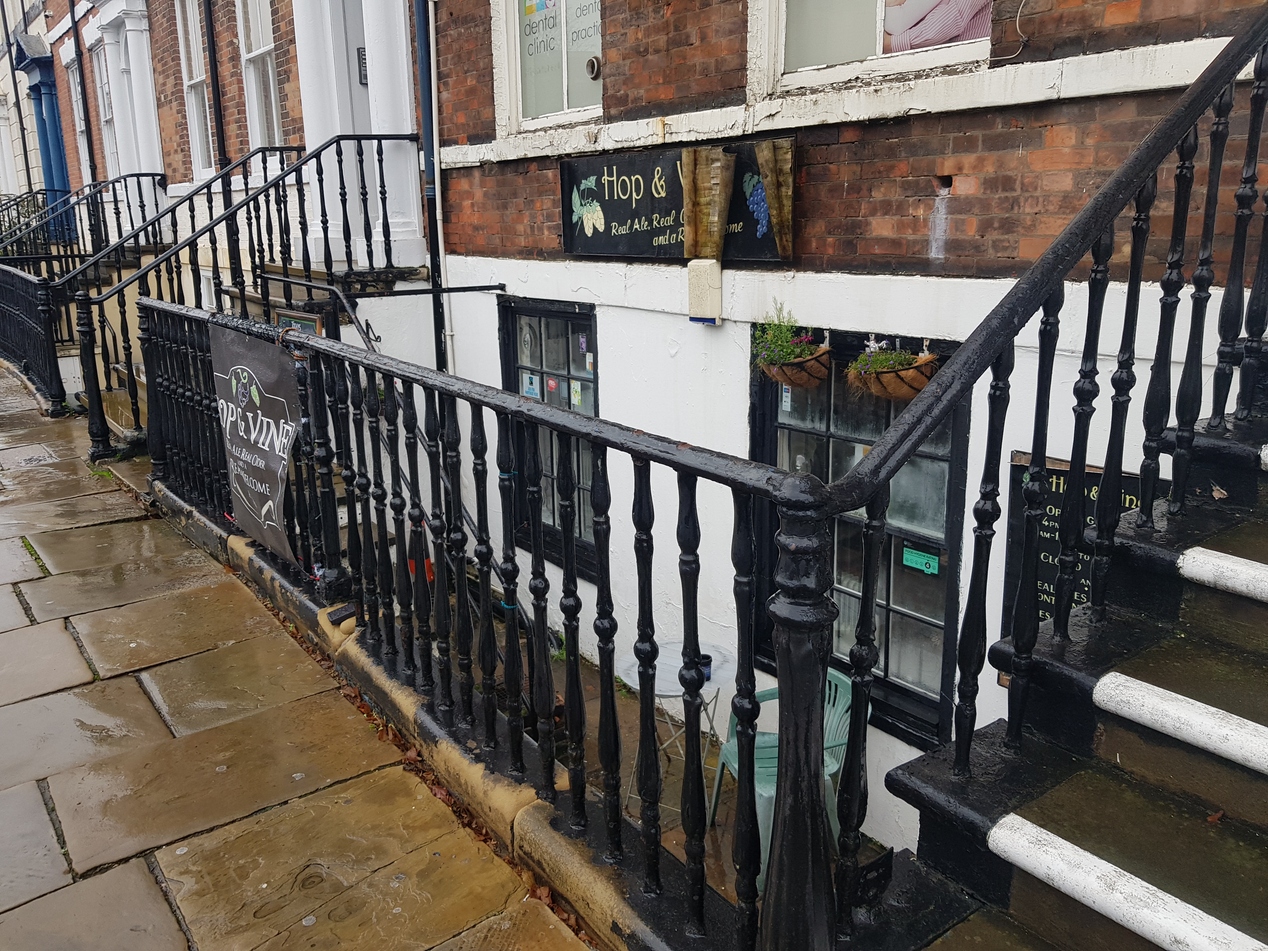
Hull – Hop and Vine
I didn’t pay much attention to the exterior of this pub when I went in as it was pouring with rain and I knew I wanted to visit this cellar bar because it’s listed in the Good Beer Guide. By chance and referencing something else, when I was in this pub I mentioned to the landlord that pubs could have a refurbishment, but if they didn’t change the core customer service, products and ambience, then they were wasting their money. A bit like the endless Greene King refits that some of their pubs seem to go through.
And, this pub probably could have done with a refurbishment itself, but it didn’t really need to as its core offering was as close to perfection as I can imagine it can be. But, more on that shortly.

I did notice this when entering and it’s a balanced selection of beers for the small size of the pub. It’s a good idea to put this sign at this particular point, very tempting for potential customers.

A small bar and it has the advantage that the landlord can see customers as they come down the stairs. So he jumps up ready to serve them and offer a friendly welcome. That’s marvellous for a start. And what I will say about the landlord here is that he’s the best I’ve encountered in five years of pub visits and probably several hundred pubs that I’ve been to. Not only was he personable, engaging and welcoming, but it was clear from the other customers that he had also created an atmosphere where customers welcomed each other. There are nearly no pubs that I’ve been to like this, it’s an art form which seems to not even be attempted, let alone perfected.
George Orwell set out his perfect pub in Moon Under Water, but if I was setting out my perfect pub, then it would be something like this. Glorious.

To be honest, even if the beer choice hadn’t have been good, then I’d have still be gushing with praise about this pub. But, the beer choice entirely met my needs, the Old Moor Porter from Acorn. A drinkable beer, slight coffee and vanilla flavours to it, not too heavy.
The one thing that irritated me about this pub is that it isn’t in Norwich, although that is perhaps just a slightly unfair criticism. But, this would be my local if it was in Norwich. They did food such as pie and gravy and some other meals, but I was neither eating and I think that the food wasn’t available during my visit. Either way, the menu options looked marvellous for when they were serving, so it made me like the pub even more.
I’ve been to two other pubs this year that I’d consider exceptional, the Old Post Office in Ingleton, Calverley’s in Cambridge and now this one. How very lovely indeed.


