The Dictionary of the Vulgar Tongue was first published at the end of the eighteenth century, and given that the Coronavirus crisis is giving too much time to read books, I thought I’d pick a daily word from it until I got bored…..
Chuck Farthing
The dictionary defines this as “a parish clerk” and I have no idea how that’s supposed to have come about. ‘Chuck farthing’ is best known as a game that essentially involves getting a farthing coin into a hole. And, this was a big game, which one MP complained in 1839 was debated for three hours in the House of Commons, but that was required as it became quite a common gambling option and legislation was considered. In 1884, the Dean of Manchester Cathedral said that “it was not right to stop a boy playing chuck farthing”, a situation that had arisen because there remained fears of gambling.
Wikipedia has a nineteenth-century description of how the game, which existed since at least the seventeenth century, worked:
“Each competitor starts with the same number of coins. They pitch their coins one at a time from a mark at a given distance towards a hole in the ground. The competitors are ranked based on how close they come to the hole. The competitor closest to the hole receives all of the coins and proceeds to a second mark nearer to the hole, from which he throws all of the coins at once towards the hole. All of the coins that remain in the hole are his to keep. The remainder of the coins are given to the next closest competitor, and the process is repeated until no coins remain.”
It’s clear to see how gambling became a problem here, especially when the game was played for hours in pubs.
But back to the parish clerk definition of the term, this goes back to at least 1655 when ‘A Satyr Against Hypocrites’ was written by John Phillips. And, perhaps the hypocrites bit is important, maybe parish clerks played the game regardless of the betting issues related to it. But, who knows….
Judging from this, the game went out of fashion long before the farthing coin ceased to be used at the end of 1960.
This walk was socially distanced….. And is the fourth walk in preparation for the 2021 LDWA 100. But isn’t an LDWA walk in itself, because these have all been suspended until the troubles are over.
WALK NUMBER: 4 (Norwich to Eaton)
DISTANCE COVERED: 10 miles
NUMBER OF NATHAN’S FRIENDS WE “ACCIDENTALLY” BUMP INTO: 0
SUFFICIENT BEER CONSUMED: Yes
PUBS VISITED: 0
WEATHER CONDITIONS: Far too hot
ATTACKED BY ANIMALS: No
NUMBER OF SNAKES SEEN: 0 (but warning signs of killer snakes were noted)
Our fourth walk was never going to be our most interesting, we wanted something shorter as I’ve been getting a bit too obsessed with walking recently, and Nathan exhausted himself with his 15-minute bike ride last week. Or was it 15 miles? I don’t know, it doesn’t matter, it’s easy to get muddled up. So, the walk was through the metropolis of Norwich to see the wealthy denizens of Eaton.
In the centre of Norwich, this is the new St. Anne’s Housing development, it’s the first time that I’ve noted we can walk through the centre of the complex. Incidentally, look at how blue the sky is. That means one thing, it’s too bloody hot.
Oh, on a related subject, I don’t like to talk about my bravery, but I had a lot of pollen-related issues. But, I didn’t let that stop me and I could tell Nathan was very impressed with how courageous I was. He didn’t say that, but sometimes you can read between the lines.
I had better also add, whilst mentioning my bravery, that I was getting a slight problem with shin splints last week so I cut my walk distances down on Friday, Saturday and Sunday (thanks to Richard, Rob and Clive for accepting a downgraded distance) but the issue seems to have mostly gone away. I wouldn’t have mentioned it, but it’s important to be honest about these walks, and so it would be amiss of me not to mention my courage and rigour.
I walked by Tesco, so I thought I should get some water. Couldn’t find the water, so I got Nathan and myself some beers. Keenly priced, but this one from Dark Arts was a little unexceptional, but perfectly drinkable. This is a small park in Eaton, with streets that are named after golf courses, such as Carnoustie, Wentworth, Sunningdale and Turnberry. There wasn’t though Mousehold Pitch and Putt, which would have made for a great street name.
Then there was a philosophical discussion, which I was proved right on, about using Runkeeper for tracking walks. I view a walk as one entity and just pause Runkeeper when sitting down or having a break. Nathan, for reasons unknown, seems to think that he has to class it is a new walk every time we have a break or stop. So, Nathan completed 26 walks in one day, whilst I just did the one. I didn’t say much about it as I was patently right.
Snakes?!?!?!?! We made a decision to rush through Marston Marsh which is a nature reserve located on a floodplain.
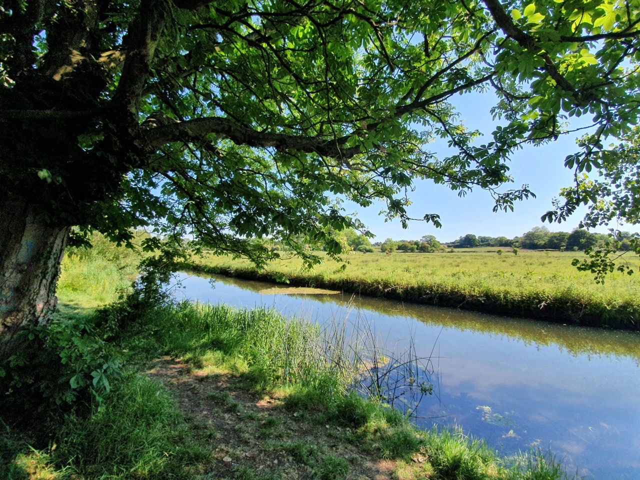
Photos of the River Yare as it winds through the marshes. Plenty of fish and tadpole things in the water and there were relatively large numbers of people walking along the riverside.
We accidentally went on a detour to check how this Greggs was getting on. Not open yet of course, but it will be soon enough. It was almost possible to smell the ovens preparing the next batch of chicken bakes, but I feel that my imagination might have been running away with me somewhat.
This is the former Post Office in Lakenham, constructed as a residential property in the early seventeenth century, with numerous later additions.
The derelict Lakenham Cock pub, trading since the mid-eighteenth century it closed in 2015. This is likely a perfectly viable pub in terms of its location and size, but the building has now become damaged and the repairs to make this a working pub would be substantial in cost. The property was being sold for £750,000 as a residential property, which puts it out of the league of anyone wanting to re-open it as a pub.
Lakenham has a village charm, but it really needs something at the centre of its community. And a pub would be marvellous.
I don’t know whether this is the River Tas or the River Yare, they seem to merge a bit here and I’m easily confused at the best of times. And it doesn’t matter, you can pick which name you prefer and use that. That’s some academic rigour there…
And, we accidentally stopped at the Fisher residence for supplies of water. She didn’t let us down with her cooking skills either, with her personal culinary calling card of chicken strips and olives being very welcome.
Then the walk back into the centre of Norwich. Nathan told me not to mention that he was worried how we would get past the road construction, so I won’t say anything.
And that was that, a basic ten-mile walk with nothing of huge excitement, but since it’s part of our training programme for the 100, I’m writing about it anyway. And, unusually, we didn’t see any of Nathan’s legion of friends, but I’m sure they’ll make an amazing appearance in the next episode.
As this is a shorter, and frankly less interesting, walking report, I thought I’d mention something else which is far more important. Although we’re training for the LDWA 100, we’re also doing this for a long walk that four of us are planning for 2022. For those who know me, I’ve been won over by Liam’s two angelic younger children, who frankly are a constant delight to take on day trips. One of them happens to have Duchenne, and this is a troublesome condition that needs funding to find a medical solution, as well as to support families in managing it. There’s more about Duchenne at Duchenne UK for those who want some background.
Our 2022 walk, of which we’ll talk more about during this year and 2021, will aim to raise publicity and funding for Duchenne. So, for the first time, I can excite and delight the three readers of this blog, as not only will this blog feature our efforts at the LDWA 100 in May 2021, it’ll also then be the prelude to the whole 2022 adventure. That will be a contribution that we can make to help end Duchenne.
The Dictionary of the Vulgar Tongue was first published at the end of the eighteenth century, and given that the Coronavirus crisis is giving too much time to read books, I thought I’d pick a daily word from it until I got bored…..
Chop-Stick
The dictionary definition is simply “a fork”, with the first usage of the word in English being at the end of the seventeenth century. It’s too far back in history to work out, but it’s likely that the ‘chop’ meant quick and had been picked up from travellers to China. At some stage, the word became an alternate name for a fork, before more recently returning to its original meaning.
The use of the word chopstick over time, a relative surge since the 1970s. I’m a little surprised though that people at the beginning of the nineteenth century would be freely using the word chopstick, I thought it was a word brought into the English language much later on.
I posted earlier about how the Norfolk and Norwich Archaeological Society have made back issues of their journal available on-line. And, there’s an article by JC Tingey that was published in 1900 which gives some ideas about the route of the Ickneild Way across Norfolk.
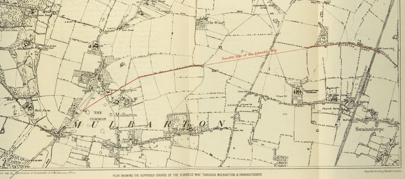
The Ickneild Way is an ancient trackway that ran from Wiltshire to Norfolk and although some sections are still major footpaths, such as the Ridgeway, some stretches are lost. Tingey’s map of where he thought the trackway went in Norfolk is interesting, as we (Nathan and me, not Tingey and me…..) walked some of this route a couple of weeks ago.
And this is the map proposed by Tingey, and we followed the left-hand section of the red line, leaving the route as it can be seen the path is no longer there. But, the author has a good point, there is a missing stretch of path that connects two other sections. It’s not something that I’ve thought about before, but it’s an interesting theory.
I posted earlier about how the Norfolk and Norwich Archaeological Society have made back issues of their journal available on-line. Meandering through a few issues, the Reverend W. Hudson wrote in 1884 about the stone bridge at Horse Fair. He noted:
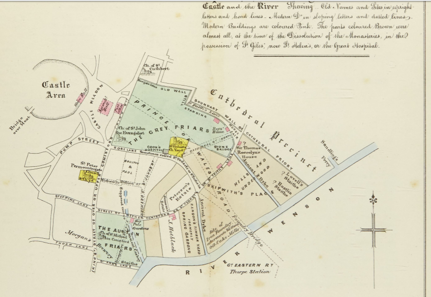
“Of the hundreds who in the course of a year make their way from Prince of Wales Road by St. Faith’s Lane into the Lower Close, probably nearly all could at once call to mind the old wall which skirts the road on their left; but scarcely one, perhaps, is aware that if he keeps close to the wall, at a point not far from where the wall bends round towards the open space called the Horse Fair, the ground is hollow under his feet, and he is in fact crossing over a bridge which once spanned a dyke which passed under the road”.
Over 135 years later, that road layout hasn’t changed and I’m one of no doubt many who wasn’t aware of this bridge either.
The full-sized map is visible by clicking on the above image, and I had no idea there was once a bridge here. Prince of Wales Road had just been laid out at that stage, hence why it’s pencilled in.
This is a really useful thing to do, the Norfolk and Norwich Archaeological Society have scanned and made available all the back issues of their journal, Norfolk Archaeology. So, that’s 44 volumes and 1361 articles. Most useful.
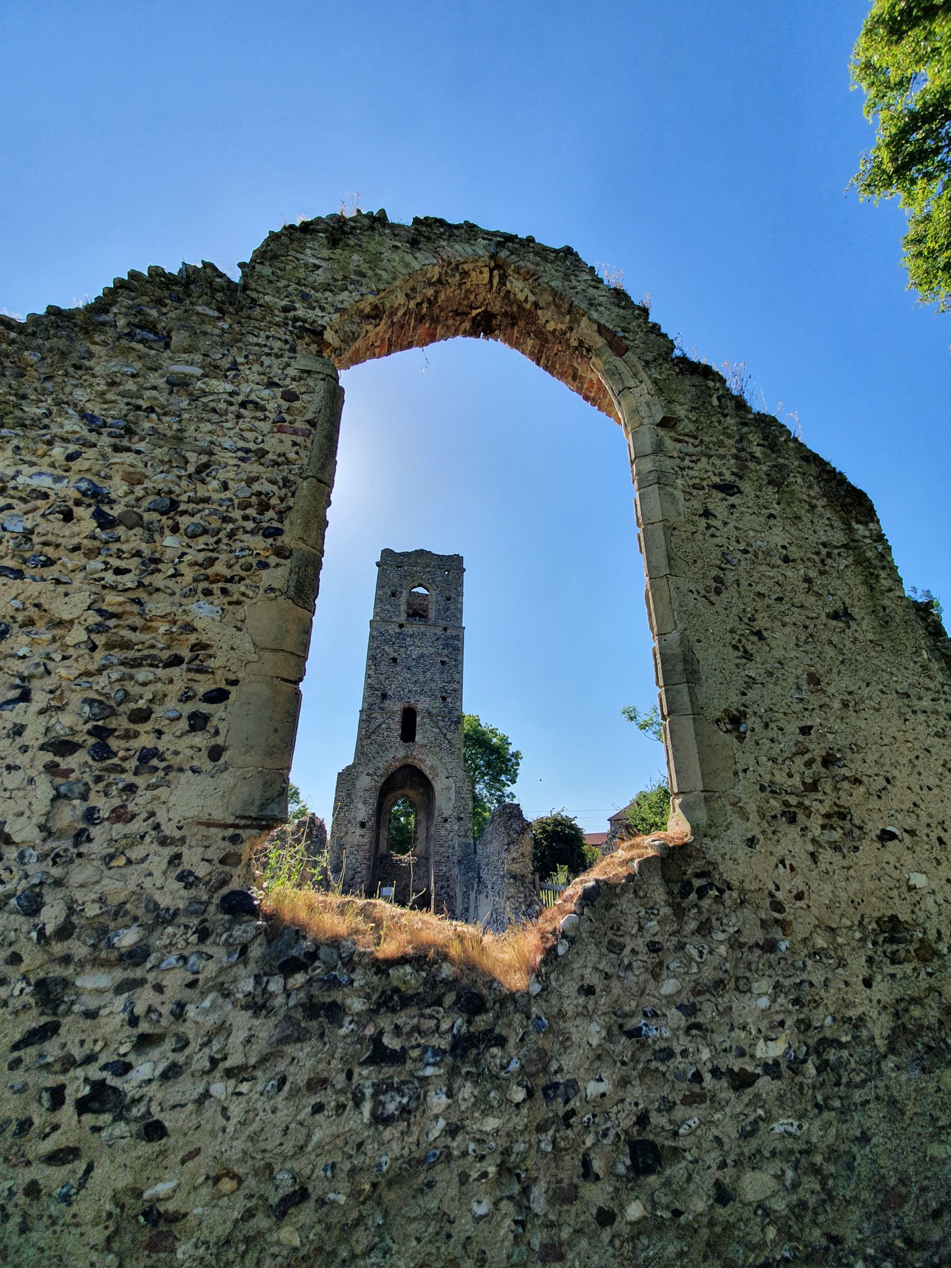
This ruined church is in Shotesham St. Mary and it’s dedicated to St. Martin, having originally been constructed in around the eleventh century. Most of the current building, or what’s left of it, dates to the fifteenth or sixteenth centuries.
Looking towards the tower from the east end of the church. Walking with my friend Rob, he mentioned how clear the sky was without any aircraft trails visible, which is quite right but isn’t something that I’d thought about.
The walls are made of flint, with some brick dressing, and are surprisingly robust in the sections that remain. They’ve received some work recently to strengthen them, so hopefully they’ll last for some time yet.
The church was abandoned in probably the seventeenth century and it had become derelict by the nineteenth century. Given how many other churches there are in the Shotesham area, even the Victorians didn’t feel the need to restore this one.
The former roof line where the nave met the tower is visible, but the high quality of the construction is apparent at the top of the arch.
Until a few years ago, this church was covered in ivy which had taken hold from the 1950s and had made it more difficult to visit and it was also causing long-term damage to the structure. The work to clean up the site led to the discovery in the south wall of evidence of the location of the holy water stoup. There are no gravestones visible, but the site remains consecrated and it’s in the care of Shotesham Parochial Church Council.
The Dictionary of the Vulgar Tongue was first published at the end of the eighteenth century, and given that the Coronavirus crisis is giving too much time to read books, I thought I’d pick a daily word from it until I got bored…..
Choak Pear
Quite a lengthy definition this:
“Figuratively, an unanswerable objection: also a machine formerly used in Holland by robbers; it was of iron, shaped like a pear; this they forced into the mouths of persons from whom they intended to extort money; and on turning a key, certain interior springs thrust forth a number of points, in all directions, which so enlarged it, that it could not be taken out of the mouth: and the iron, being case hardened, could not be filed: the only methods of getting rid of it, were either by cutting the mouth, or advertising a reward for the key. These pears were also called pears of agony”.
And the instruments that the dictionary refers to have since been created to show what they would have been like. They are though almost certainly a figment of imagination from the early author, F. de Calvi, who first mentioned them. It’s true that devices like this were used as gags in punishment, but there has been no evidence present for criminals ever using them.
If a criminal of the time wanted to steal something from someone, they could easily do that. The chances of them having some complex mechanical device which they then used to extort a ransom seem low, there must have been easier ways for them to manage to get money out of their victim. I’m blaming the grub street press again, keen to sell newspapers and scare people, this would be the perfect story to spread. A few newspapers reported the device, but they all referenced Grose’s dictionary.
So, the stories behind devices also known as Pears of Agony or Pears of Anguish are likely false, with the museum pieces mostly dating to the nineteenth century. But if they were true, this must have been a hideous thing to endure.
It’s been a couple of years since I’ve been to Shotesham and my visit today saw some warm weather. A bit too hot, but there we go. Anyway, the origins of the village name.
The Concise Oxford Dictionary comments on this name:
Shotesham, Norfolk. Shotesham in 1044, Scotesham in Domesday Book, Schotesham Omnium Sanctorum in 1254. Scott person, literally from Scotland or Ireland.
The 1254 longer version of the name means Shotesham All Saints, but it’s impressive that the village had the same unchanged name nearly 1,000 years ago of Shotesham. The ‘ham’ means farm, homestead or settlement, but I’m not sure what Scots person exactly this is named after. I’m sure that whoever it was that they’d be surprised to see just what a legacy they had on the area.
Located near to the village of Shotesham, near to All Saints Church, is this sign which gives some history about why there’s a hole here.
The depression, which is a little hard to make out here now because of the trees, was caused by a German V2 missile which caused damage to 43 buildings in the village. It was fired on 6 October 1944, the only such attack in the UK that day, and fortunately no-one was hurt during the explosion. As the sign notes, it’s not entirely clear what the Germans were trying to hit, but it’s thought that it might have been the Radar Station at Upper Stoke. So, it wasn’t a marvellously accurate attack, as that’s a few miles away.
The rocket was fired from Rijsterbos in the Netherlands and it travelled at around 3,000 miles per hour and descended from a height of fifty miles. The rockets caused significant damage to the area where they landed, with craters being around twenty metres in width and eight metres in depth. If this would have been developed and used earlier in the war, its impact could have been terrifying as they were nearly impossible for the British military to be able to stop once they were fired.