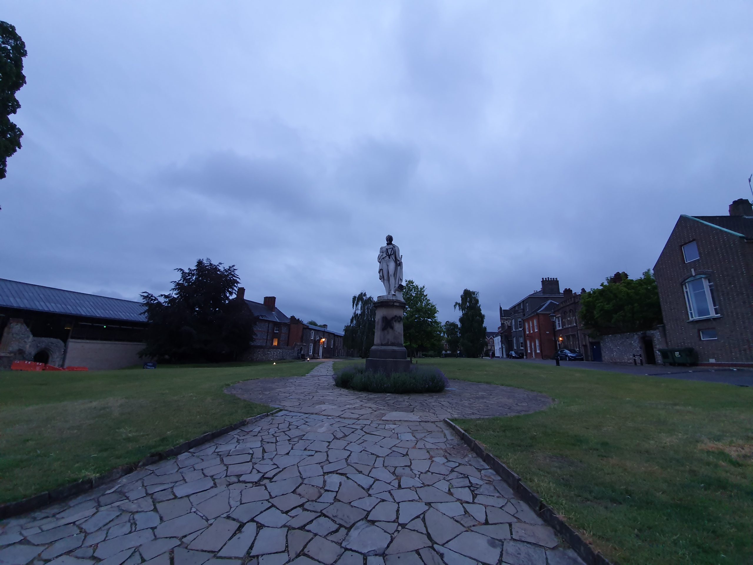
Category: UK

  • Streets of Norwich – St. Faith’s Lane (Horse Fair to Prince of Wales Road)

    Streets of Norwich – St. Faith’s Lane (Horse Fair to Prince of Wales Road)

    Part of my Streets of Norwich project….

    St. Faith’s Lane is a long road (and has historically been much longer), so this is just the section from Horse Fair to Prince of Wales Road. In the above 1880s map, there isn’t really much on this section, an orchard and a few buildings on the left-hand side and just a couple of buildings on the right-hand side, which is now Stuart Gardens.

    These houses overlook Horse Fair and were built somewhere around the turn of the twentieth century. The house with the black door is 32 St. Faith’s Lane and in 1939 it was lived in by:

    Percy Smith (born in 1891, worked as a traffic foreman for the omnibus company)

    Mary Smith (born in 1896, a housewife)

    Philip Smith (born in 1923, a trade apprentice at Laurence & Scott)

    The Regent Theatre sign is still visible on the substantial building on the right-hand side. The black doors on the right of the photo are numbers 22 and 24 St. Faith’s Lane. Having a little look at the 1939 register, these were lived in by the Thurston and Lake families respectively.

    John Lake, listed as the head of the household at number 24 St. Faith’s Lane (the black door to the furthest right of the photo) worked as a cinema electrician, which was handy if it was the cinema behind that he worked in. He was also an ARP warden, but the register marked him as an untrained warden, so I assume he had just signed up to help the war effort.

    This is the rear of what was the Regent Theatre, which became the ABC cinema (there’s an interesting video of that at http://www.eafa.org.uk/catalogue/213377) and later Mercy nightclub, which then closed. But more on this when I get to the Prince of Wales Road post, which this building fronts on to.

    More of the former Regent Theatre on the right and the entrance to Stuart Gardens is visible on the left. Ahead is Prince of Wales Road and in older maps, St. Faith’s Road went much further, but the next stretch is now known as Eastbourne Place.

  • Norwich – Horse Fair

    Norwich – Horse Fair

    I’ve never paid much attention to Horse Fair (or Horsefair) which is located along St. Faith’s Lane. It’s visible in the above map from the 1880s in two separate chunks, but somewhere around the 1950s this was shrunk down in size to what remains today.

    And this is what remains, a squashed oval shape (I’m sure there’s a better mathematical word for that) of greenery.


    People can go inside it if they want some grass, although I’d suggest that there are better nearby locations.

    The entrance has cut iron railings, I assume taken for the war effort.

    Norwich School now occupies the offices that overlook the area, suitably named Horsefair House.

    The nearby plaque is getting hard to read now, but it says:

    “The site of the Horse Fairs during the reign of King Edward I (1272-1307) and King Edward II (1307-1327). It was moved to the Castle Ditches by order of King Henry VII in 1500.”

    And, as something else I found out about later, there’s also a bridge under the road by Horse Fair.

  • Streets of Norwich – Stuart Gardens

    Streets of Norwich – Stuart Gardens

    Part of my Streets of Norwich project….

    The location of Stuart Gardens was in 1880 a load of trees in the gardens behind St. Faith’s House. That property has long since been demolished (there is still a building with that name, but it’s on Mountergate), although at least a few trees remain because of the James Stuart Gardens that can be accessed from Recorder Road.

    Not a great deal to note here, although the residents are unfortunate that this back street is right near to the central beating heart of Prince of Wales Road and its nightlife (which is limited as of May 2020, but I’m sure it’ll return). So, it doesn’t take much imagination to know what has been recorded around this street.

    The street is named after James Stuart, who I had mentioned on my Recorder Road post, a rather fitting name given its location. It’s just a small cul-de-sac, which is reached from St. Faith’s Lane.

  • Norwich – Metal Relief Sculpture of St. Benedict

    Norwich – Metal Relief Sculpture of St. Benedict

    Located at the end of Wellington Lane where it meets St. Benedict’s Street is this metal sculpture of St. Benedict, which I had mistaken for a modern installation. It transpires that the metal relief sculpture itself is from a branch of the National Provincial Bank on St. Benedict’s Street which opened on 27 October 1957. It was installed in this format in 2012 and there’s more information at http://www.racns.co.uk/sculptures.asp?action=getsurvey&id=147.

    On the reverse is the name of the road that it is next to, Grapes Hill.

  • Streets of Norwich – St Lawrence Little Steps

    Streets of Norwich – St Lawrence Little Steps

    Part of my Streets of Norwich project….

    This short lane connects Westwick Street and St. Benedict’s Street, taking its name from St. Lawrence’s Church.

    The steps at the bottom, leading onto Westwick Street.

    The churchyard is to the left.

    Looking back down to Westwick Street, with an entrance to the fifteenth-century St. Lawrence’s church on the right-hand side.

    And another set of steps up to St. Benedict’s Street.

  • Streets of Norwich – Wellington Lane

    Streets of Norwich – Wellington Lane

    Part of my Streets of Norwich project….

    Wellington Lane today is a strange little affair, running parallel to the inner ring-road street (I say street, more like a minor motorway) of Grapes Hill. Back in 1900, Wellington Lane is visible, but it now also covers what was Duck Lane. Grapes Hill was widened after the Second World War, so there is now no housing between Wellington Lane and Grapes Hill, it’s a soulless area of the city where the car triumphed.

    This metal relief sculpture is located where St. Benedict’s Street and Wellington Lane meet, but more about that sculpture here.

    Starting from the Duck Lane end, the city wall is on the right-hand side and these sections were previously embedded into housing.

    A relatively long section of wall which has been mauled about over the centuries, but at least something has survived.

    A gap between the wall, which starts to peter out at this point.

    Looking back towards the Duck Lane end, the line of the wall has been retained.

    The line of the wall goes shooting off into the bushes, with Grapes Hill on the right. There was an intriguing square tower here, but it was pulled down as part of the road expansion plans.

    This is now getting towards the end of what was Duck Lane, and now into what was always known as Wellington Lane. Somewhere around where that tree is at the front, that was once the Wellington pub, which is how the street got its name. That pub, built in the mid-seventeenth century as a residential property, traded between 1822 and 1930, part of the Youngs & Co estate in the later part of its period of operation.

    The bushes on the right are the former stretch of residential properties along Wellington Street and the city wall existed in this section. However, the whole lot went as part of the Grapes Hill road widening, although some of the properties in this area had already been lost or damaged during the Second World War.

    The road starts to end here, connecting in with St. Giles Street on the left.

    And looking back down Wellington Street, a heavily changed road over the last century. The houses on the left have gone as part of the Grapes Hill construction, and although some efforts have been made with landscaping, it’s not the most glamorous of areas. The road is so busy that it can’t be easily crossed, but there is a pedestrian bridge now so that people can get over to the Earlham Road area.

  • Norwich – St. Ethelbert’s Gate

    Norwich – St. Ethelbert’s Gate

    St. Ethelbert’s Gate is one of the two main entrances to Norwich Cathedral close, the other being the Erpingham Gate. It was first constructed in 1316, but the reason for its being dates back to the thirteenth century.

    It’s fair to say that the monks in the cathedral didn’t entirely always get on with the ruffians that formed the population of Norwich at the time. There was a busy market at Tombland, which was perhaps quite raucous from time to time with its fairs and parties.

    At this time, the church was also powerful and the monks were conscious that they exerted significant influence. The fairs had been established for the financial benefit of the monks and there were three per year, but instead, the city residents used them to amuse themselves by “displaying goods and animals”. This wasn’t really what the monks had wanted and there’s some suggestion that the residents of the city were trying to best to irritate the monks as best they could.

    Arguments aside, this was all going marvellously until 1272 when the monks managed to kill some Norwich residents, which perhaps wasn’t their best idea. The legal system swung into action, but the church had consistory courts (on a side note, Norfolk Record Office still have the papers from these courts and they’re well worth looking at) and so they were quite content for, well, the monks to deal with the action of the monks.

    The population of Norwich didn’t take well to this little arrangement, so they argued about it with the monks, who promptly locked the city gate. Perhaps the monks may have got away with this if it wasn’t for them employing mercenary soldiers who were accused of amusing themselves by firing at passers-by. To be fair, if I was walking in Tombland and was attacked by a representative of a monk, I would have been displeased.

    And, the people of Norwich showed their displeasure in quite a violent way. They set fire to the whole cathedral and its attached buildings, causing significant damage to the structure and destroyed buildings such as St. Ethelbert’s church. They also pinched the nice things of the cathedral, such as vestments, they damaged books and killed some monks, with some other monks fleeing.

    I’ve never found that violence such as this is the answer, whatever the population of the city might have thought at the time. But anyway, in 1272 Norwich isn’t looking in the best of shapes at this time. There’s now a burnt-out cathedral, angry monks, angry residents and a not inconsiderable amount of tension in the air. It was time for King Edward I to come to Norwich to see what his subjects were getting up to.

    King Edward I, by most accounts, wasn’t best pleased. He blamed the city’s residents, which was perhaps more tied in with the power and influence of the church, but that’s a different matter. He fined the wealthy of the city and for the riff-raff, or “the inferior sort” as they were termed at the time, well, he just executed some of them. To balance things out a bit, he imprisoned some of the monks (although not for long, he was already worried about the Pope not being happy) and ordered that everyone should now try and get on. He actually just installed wardens to supervise the matter, but the intention was that everyone should get on.

    To try and resolve the situation that now existed, in 1275, it was decided that there had to be some financial payments made to settle the matter. This included the construction of a new gate, since the city dwellers had smashed the old one down, and it was to be dedicated to St. Ethelbert since the church with this dedication had also been knocked down.

    And here’s what they built, with everything finished off nicely in 1316. Looking out towards Tombland, the room above the gateway was once used as a chapel but is now a classroom that I’ve visited several times. The entire structure was repaired in 1815 under the supervision of William Wilkins, an architect who also built the city’s new prison in the castle.

    The Lierne vaulting on the roof of the gateway, with the walls on either side looking somewhat battered now. Unfortunately, the location of the gate means that it has to remain open for road traffic, with pedestrians pushed towards the sides. On the left-hand side is a doorway which is an entrance to the room above, although another more practical set of stairs has been constructed which reaches the room from the next-door building.

    Incidentally, the monks and the city residents didn’t settle their differences and the arguments persisted for decades. But at least the monks had a lovely new gate to use, and it’s a fine structure which the city is still fortunate to have. So something positive came from the rioting.

  • Norwich – St Mary the Less Church

    Norwich – St Mary the Less Church

    This is the only one of Norwich’s medieval churches, and the city has a lot, which I haven’t visited. It didn’t open on Flintspiration weekend a couple of years ago when the others did, so it’s something of a challenge to see inside. The heritage bodies have struggled to get their representatives inside and it was last opened to the public back in 2010. There is though an information board, visible above, which draws attention to the gateway, as otherwise, it’d be easy to miss it.

    The church was originally built in the thirteenth century with extensions in the fourteenth and fifteenth centuries, but it became redundant during the mid-sixteenth century. Used by the Dutch migrants as a trading hall, it returned to religious use in 1637 when it became a French Protestant church. This state of affairs existed until 1832 when it became a Swedish Lutheran church, then in 1869 it became a Catholic church once again, just as it had initially been. After the Second World War, it stopped being used as a church and was instead rented out as a storage facility and community building.

    This is the doorway that leads from Queen Street, with the church having been rather hemmed in by buildings on all sides. That graffiti is annoying (and has been there for at least three years), but most people are unlikely to notice it since this isn’t exactly a door that’s ever open. As ever, George Plunkett has a photo of the interior of the church.

  • Streets of Norwich – St. Augustine’s Street (West Side)

    Streets of Norwich – St. Augustine’s Street (West Side)

    Part of my Streets of Norwich project….

    This is how St. Augustine’s Street looked at the beginning of the nineteenth century. Starting in this post just with the buildings on the west side of the street.

    The road starts with St. Augustine’s Church, but more on this in another post as I went on a tour of this rather lovely church and have plenty more photos. But, what is perhaps of most obvious note about the building is its brick tower, which dates to the seventeenth century and is the only one of its type in Norwich.

    This is the entrance to Winecoopers Arms Yard, the building that juts out is the former pub of the same name (without the word yard at the end obviously). The buildings on the far left, next to the trees, are mostly all listed and were constructed in the early nineteenth century as shops and residences.

    The building on the right-hand side (and indeed those attached to it along the street) are listed, as they’re seen as important examples of early nineteenth shopfronts. The corner building itself was once the Sussex Arms public house which traded from the 1850s until it was closed by Bullards in 1963.

    The building in white was the Royal Oak public house, the pub sign was once where there’s a stretch of white wall which looks like it could have a window. The pub had started trading in the late eighteenth century and survived until the late 1960s, when it was converted into a residential property.

    Stretching into Bakers Road, this is the side of the Staff of Life public house. It was opened in the 1830s as a bakery and pub, remaining open until 1971, despite being damaged during the Second World War.

    Not much has really changed on this side of the street, the buildings have changed their uses, but most of them have survived. Some of the yards have been closed off, but again, many of the structures in them remain. The element that has changed the most is that this is no longer an upmarket shopping street, as it was split off from the main shopping area by a clumsy road development that lost Botolph Street. The tone of the street changed and most of the shops closed and the area didn’t have the best of reputations.

  • London – British Museum (Ship Tavern, Great Yarmouth)

    London – British Museum (Ship Tavern, Great Yarmouth)

    I usually visit the British Museum three or four times a year, something which is a little difficult to do with the current virus situation, primarily because it’s shut. However, they’ve placed hundreds of thousands of images on their web-site, so this will have to do me for the moment. The images can be used non-commercially, as long as the British Museum is credited. So, this is their credit.

    I’m not sure that there’s much advertising from pubs at the turn of the nineteenth century surviving, especially not in two languages. But this advertising card in English and German is now in the collection of the British Museum and they acquired it in 1960 from the estate of Sir Ambrose Heal. Heal was a collector of trade cards, and had a large number in his collection, as well being the chairman of Heal’s on Tottenham Court Road, which is still trading.

    The Ship Tavern is though sadly no longer trading, it lasted from the 1760s until 2010, being located next to Row 84 in the town. But there’s something quite captivating about how multi-national the docks and port of Great Yarmouth once were. Indeed, in 1797 this pub had welcomed (I use welcomed slightly loosely here….) Dutch naval prisoners from the Battle of Camperdown. As for William Ungleman who produced these trade cards, he ran the pub between September 1809 and 1819, but I have no idea where he went after that.