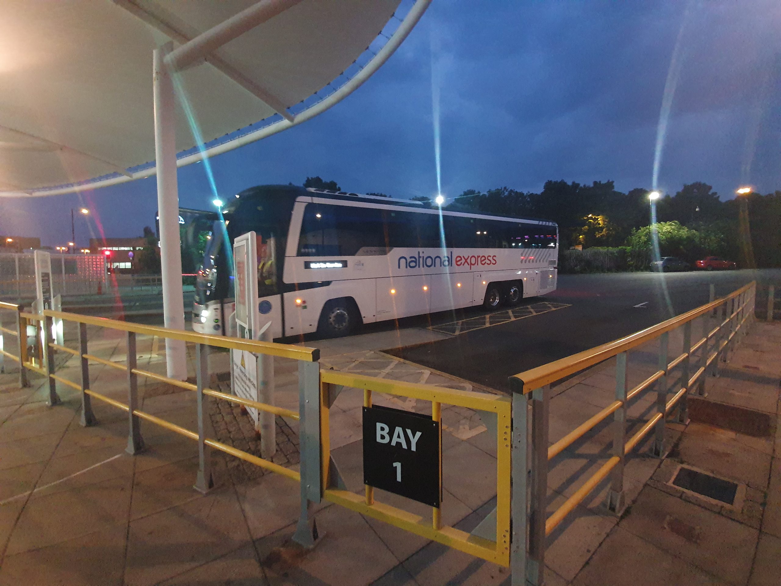
Category: UK

  • Norwich – Artichoke Pub

    Norwich – Artichoke Pub

    The Artichoke is the pub that I visit most in Norwich, although I’ve never made the effort to write a post about it on here. Since pubs have re-opened now, or at the least the outside of them have, I thought I’d go to my favourite Norwich licensed premises, and it’s where I stayed nearly the entire day. Thanks to Brian, Gordon, Nathan, Megan and James for keeping me company during the day…….

    Anyway, the background to this pub is that it was quite generic in its offerings in previous years and perhaps in danger of being closed down permanently and for it to become another casualty of the pub trade. It was taken over by an independent operator, Kevin Tweedy of the Golden Triangle Brewery, and the pub has been transformed over the last few years into a venue that is busy, well managed and has an excellent beer range.

    Ordering at the moment is via either the Artichoke app or by asking a staff member directly, with payment being by card only with no cash accepted. The app perhaps needs some work as there were some technical issues with it, but if nothing else it was a useful way of seeing the beer list. The pub wasn’t as busy as I thought it’d be during the day, although it was often nearly at capacity, but never quite reached it for very long. The weather was tolerable throughout the day, but got rather colder later on and my feet started to feel just a little chilly. What did remain for the day though was the welcoming atmosphere, this is a very non-threatening location.

    The beer selection in the Artichoke is what I’d consider to be the best in Norwich, not reliant on a few generic and dull options, but instead offering an ever changing selection of beers. The outstanding ones from my visit yesterday were:

    Big Idjit from Dugges Bryggeri

    Trium Faba from Three Hills Brewing

    Must Kuld Chilli & Chocolate from Pohjala

    Yuzu Juniper G&T Raw from Three Hills Brewing

    As an assortment of beers to have available, I think that’s pretty impressive. The staff here are very knowledgeable about the beers, some of the best drinks knowledge that I’ve seen in a pub. That’s some enthusiasm and good training there, with the staff being able to make suitable recommendations when someone just asks for a lager. As for downsides, I’m not sure that there really are any, not least anything which is sufficiently annoying to comment on. Perhaps the only minor problem at the moment is that the beer garden seems to allow smoking throughout the entire area, which isn’t ideal at all for non-smokers. But, it’s not long until the inside of pubs can open again.

    These photos are from pre-lockdown, a reminder of what it was like to sit inside pubs.

    These are a random selection of the cask and keg lists that the pub has had over recent years, but there’s also a long list of cans and bottles in addition to this. Food isn’t always offered in the pub, beyond Pipers Crisps (although these are very moreish) and nuts, but on some weeknights and on Sunday afternoons there is the XO Kitchen which offers a range of small plate options.

    Anyway, as a pub, I very much recommend the Artichoke and I think it’s lifted the entire area. And, it’s also listed in the Good Beer Guide.

  • Norwich History by Parish : St. Michael at Thorn 1/2

    Norwich History by Parish : St. Michael at Thorn 1/2

    And a new little project that Jonathan and I are undertaking because this lockdown went on for longer than we had anticipated, so we had time to do this. It’s a bit niche (our project I mean, not the lockdown), I’ll accept that, but there we go. Effectively, it’s walking around Norwich, ancient parish by ancient parish and seeing what is there now compared to a map from the 1880s (and the 1920s). There’s a PDF of these boundaries to provide some extra background to this whole project.

    This week’s meander was around the parish of St. Michael at Thorn and this is one that has been badly hit by a combination of war damage and what I would consider to be quite incompetent city planning. The church was damaged during the Second World War, but it could have been replaced or the tower saved. Instead, the site was tarmaced over and turned into a car park. Housing and pubs on the other side of Thorn Lane were torn down in the 1960s and replaced with a small number of commercial units, but mostly more car parks. There are relatively few old buildings surviving on either side of Ber Street and the entire area between Surrey Road (sometimes now all referred to as Surrey Street) and Ber Street has been flattened to build car parks. All of the yards were removed and no parish boundary markers remain today that we could find.

    Such is the devastation caused by the demolition, not one single listed building seems to remain in this parish. However, there is some good news, there is another part of St. Michael at Thorn parish which is near to the castle, separated by St. John Baptist Timberhill parish, so that’s where we will visit next week.

    The centre of this parish is (or was) St. Michael at Thorn parish church, located on Thorn Lane. Or, as some local wit has amended it to here, Thorne Lane. The church was originally known as St. Michael on the Hill, but also as St. Michael Spinas, which is the Latin word for thorns. So, they’ve named a church as it had a load of thorn bushes in the churchyard, which were also still there in nineteenth century accounts.

    This is the corner of Rouen Road and Thorn Lane, the edge of the parish. Only this frontage is located within the parish, but this was all Paradise Place which was an area of much denser housing. It retains the same name today, but there’s more greenery and this is some of the limited amount of new property that has been constructed in this parish over recent decades.

    Thorn Lane used to carry on to the left and go down to King Street through the old brewery, but post-war redevelopments have seen that link removed. There’s a photo from around 1910 of Kahler and Sons bakers, which was pretty much in the centre of my photo above.

    This map from 100 years ago is hard for anyone today to be able to place into the current landscape, but the top section (on the left) of Thorn Lane is still there, and King Street is still there on the right of the map. Rouen Road ploughs through the middle of the map today, roughly where the ‘A’ in Thorn Lane is located on the map.

    This is today the entrance to the EDP’s car park, but it was once where Bacon’s Square was located, named after Nicholas Bacon’s house which was located nearby. Just to the right of this, George Plunkett took a photo in 1937 (whilst standing on Thorn Street) of what was then Middle Square.

    A rather faded sign which notes the church that was once here.

    This is a planning mistake, and quite a sizeable one in my view. George Plunkett shows what was here in the 1930s, which was St. Michael at Thorn church from which this parish takes its name.

    There was likely a church here from the late Saxon period, but it was rebuilt in the medieval period and a steeple added in 1430 following another major rebuilding effort.

    There was another substantial renovation which took place in the Victorian period, with this plan dating from 1870. It could be argued that this didn’t go entirely to plan, as the tower fell down on 3 November 1886 which wasn’t at all ideal, especially as it took some of the nave with it. The cost of this restoration, which restored the tower to its previous appearance with the exception of the pinnacles and a parapet, cost £500 and the church struggled to raise this. I have some sadness here to think of how much people struggled to raise this money for their church, which they viewed as important and wanted to be successful. They did well though, the damage was repaired within one year of the tower collapse and the service at its reopening was very well attended.

    The nave and chancel of the church was destroyed during air raids during the Second World War, but the tower survived. There was talk of rebuilding the church in 1948 and costings were drawn up, but this was at a time when there were enough churches in Norwich and there wasn’t enough support for its reconstruction. Just down the road, St. Julian’s Church had also been damaged and it was decided that only one church needed saving. Indeed, the door from St. Michael’s was used as part of that reconstruction, so at least something remains. The Church of England had the power though to do more here, they were quick to demand locals pay money that they didn’t have to repair the church in times of need not that many decades before, but they abandoned it with perhaps undue haste. Anyway, George Swain took a photo of the doorway in 1952, just before it was moved.

    As for the reuse of this site, I think it was idiocy to turn this entire area into a car park. It could have been turned into a play park as happened at St. Paul’s church in the city, something that was a useful amenity to the local population. It was decided to save the towers at St. Bartholomew’s Church in Heigham and St Benedict’s Church on the street of the same name, so that could have been done here.

    Located over the road from the church, likely where the residential home is now located on the corner, was a grand house. Blomefield notes:

    “The house over against the church with a large garden, of 3 or 4 acres thereto belonging was anciently John Corbet’s; then Edward Southwell’s, after that Alderman Tho. Grene’s; after that Sir Nicholas Bacon’s city house; and during the time Bishop Reynold’s was repairing the palace, he dwelt there; it was a grand house, but is now converted into small tenements.”

    Located next to the church, and bordering onto the parish of St. John the Baptist, was the Windmill pub and then two doors down from that was the Exhibition Tavern. The Windmill pub had traded as a licensed premises from at least 1760, but the building was damaged during the Second World War and the City Corporation compulsorily purchased it in 1958. They then demolished it in 1970, but George Plunkett has a photo of Windmill Alley which he took from the churchyard in 1937 and that shows the rear of the pub. The Exhibition Tavern traded from the 1860s, but was closed in the early twentieth century when it was decided nationally to reduce the number of licensed premises.

    For anyone who doubts the number of pubs in Victorian Norwich, this is what existed around St. Michael’s church in the 1870s, the PHs being public houses and the Tavs being Taverns. All I can say is what a time to be alive…..

    I don’t know why there’s a Christmas tree stuck on the side of this building in April, but this is located opposite the end of Thorn Lane.

    A sculpture which was installed here in 1999, which I’ve never entirely understood. Given that, I’ll just quote what Norwich City Council say about it:

    “The railings combine forms which reflect the tree-trunks and leaves with mechanically inspired springs and zigzag forms. They were created both for and with the residents of Brooke Place responsible for modelling the roundels in clay which were then cast in bronze and fixed to the railings.”

    Brooke Place stands today in the vicinity of where Brooke Yard was once located, although none of the streetlines match up.

    This is Brooke Place today, with the access road to it (on the John Lewis side) once being the route of Berry’s Court.

    Some street art of St. Julian of Norwich.

    This is Surrey Grove, a route that has been here for a few hundred years, although it was once a tree lined route on either side. It’s all a bit less salubrious today.

    The parish reaches Surrey Street, but on the left hand-side of Surrey Grove the only building that is part of the parish is now called the Surrey Kitchen & Bar, or what I still consider to be the Surrey Tavern. This has been a pub since at least the 1850s, and despite some regular brief periods of closure over the last couple of decades, it is continuing to trade.

    This ugly building (I think it’s ugly anyway….) is Norfolk Tower and is one of the tallest in Norwich, being the home of BBC Radio Norfolk between 1980 and 2003, when the corporation decided it needed some of the most prestigious office space in Norwich in the new Forum. The parish incorporated some of this building, but then cut back in, so it didn’t go far down Surrey Road (or Surrey Street for those who prefer that).

    Behind Norfolk Tower is another car park, but this was once where a large baptist church built in 1854 with seats for 1,400 people was located. George Plunkett took a photo of the building in 1979, but it was demolished in 1986. Some of the church might just have projected into the building on the left-hand side, although that’s another car park, this time for John Lewis.

    A closed footpath behind John Lewis, although I’m not sure where it normally leads to, unless it’s into the shop. I didn’t investigate given the signage.

    The wall here by the car park was pretty much the oldest thing remaining in this area since the council have allowed everything else to be demolished.

    This was once Glasswells Furniture Store, which opened in 1984. The building was later used as a temporary lending library following the disastrous fire which destroyed Norwich central library in August 1994.

    The path which runs behind the properties facing onto Ber Street, connecting Horns Lane with Thorn Lane. Incidentally, there used to be a Twitters Court located just by here, that would have been a popular location today if it had survived. Although I suppose people would have kept pinching the street sign, so perhaps it’s best not to be there any more.

    Just to the right, there was a Victorian urinal, handy given how many pubs were in this vicinity. And just by where that sign is today, that would have been the entrance to the Rose Tavern, which was open from the 1850s to around 1910.

    Around ten metres further down the road, this is where the Bartholomew Tavern would have stood, a pub that was open from the 1850s until the 1960s. Here’s a photo of it from the 1930s, with the entrance to Bartholomew Street being about where that tree is in the above photo. There’s an interesting dip in the road in that 1930s photo, I hadn’t noticed that before in any images.

    I like it when councils keep street lines when redeveloping an area, it anchors the area to the past even if the buildings are nearly all changed. And, I’ve never paid much attention to Garden Street, but after some checking on a dual map, it’s in exactly the same place as it once was when there was housing in the area. Indeed, the area in front of this sign was once a corner pub, the Carpenters’ Arms. This means that there were three pubs within literally throwing distance.

    There’s more information about the Carpenters’ Arms, including a photo, at Norfolk Pubs. The pub closed in 1963, so that the council could build a lovely new car park. One thing you can’t criticise Norwich City Council for is their determination to ensure there is always somewhere for people to park their car in Norwich.

    This is Garden Street today and I can see that an effort has been made to bring some light commercial zoning into the area. But, this was perfectly good housing and I think it should have remained for that usage. Instead, it’s mostly now all car park.

    That’s another parish done, and there’s surprisingly little history still remaining here, much less than I had expected for an area so close to the city centre. Next week, the other part of the parish which I hope is more history and less car park.

  • Caister-on-Sea – Beauchamp Lifeboat Memorial

    Caister-on-Sea – Beauchamp Lifeboat Memorial

    This monument, which is located in the East and West Caister Village Cemetery was listed in 2018 and it marks the events of 13 November 1901. This was one of the darkest days for the RNLI in their history, with nine crew members losing their lives when trying to aid a vessel in distress. The Beauchamp lifeboat had been brought into service in 1892, named after the family of one of the main donors, Sir Reginald Proctor Beauchamp. During its period of operation it had been launched 81 times, and after the tragedy it was salvaged and sent to Great Yarmouth for repair. However, the local men said that they didn’t want to use the boat in future, which was agreed and the boat never saw service again. Within five weeks though, a new crew had been formed, a truly brave endeavour.

    This memorial was unveiled on Tuesday 30 June 1903 by Colonel Diver, who was then the Mayor of Great Yarmouth. Public subscription had raised over £12,000, a huge sum of money for the time, with the sculpture being designed and executed by J Whitehead & Sons of 74, Rochester Row in Westminster, London. The memorial stands twenty feet high and the base is made from Carrara marble with the top section showing an anchor, a lifebuoy, a boat’s rudder, broken oars and ropes.

    The replacement lifeboat had also arrived in Caister a few weeks before, enabling the crew to keep on assisting shipping in the area.

    An early image of the monument, although the railings have since been replaced.


    And the verse that was sung after the tragedy, a reminder that they ‘Never Turn Back’.

    WHAT is this we have done?

    Why, our duty, and nothing more—

    Our sons will do it again, as their fathers have done before. It is not for the sake of bragging ; we are sailors, one and all— They signalled peril out yonder, and we—we answered the call;

    For in face of the storm, in face of the wind, in face of the rising flood, We Caister men never turn back. For why?

    It is not in the blood.

    Aye, the tempest was raging awful, and the foam flew high on the sands, And the wind and the tide were mocking the weakness of willing hands ;

    But we launched the boat for all that (God help the poor children and wives!)

    For the noblest duty of man is the salvage of human lives. Then out on the hungry breakers, where the skies were inky black, our boat seemed swallowed by darkness—she went and she never turned back;

    And we waited, and watched, and waited all night in the riving foam, Till the dawn broke on orphaned children, and the wreck of the widowed home.

    Aye, sir, I am an old man, and in speaking the tears will start;

    But them words is the voice of Nature—they spring up straight from the heart— And I says them again, as our Caister men would say with their last breath,

    Though the flare on the sands out yonder might light them on to death

    For in face of the storm, in face of the wind, in face of the rising flood, Our Caister men never turn back—for why ?

    It is not in the blood!

    I have fought in a hundred fights when battling with the sea, They are gone, the young and strong ones, but to live in our memory;

    Here they sleep by the wind-swept shore to the dirge of the moaning waves, And the Country’s tears are the blossoms let fall on the Caister graves.

    They say that the sea is cruel; they may be right or wrong— It is not for us to think—we are bound to be hale and strong. *Aye, sir, I’ve paid my tribute, and I humbly bows my head;

    But I keep a good lookout to seaward, for the sake of them that is dead. Aye, I’m proud of our Caister manhood, I’m proud of such acts of love, When I think of the names recorded in the Log Book up above;

    And I’m proud of the words you quote, in the name of myself and crew, But not because I spoke them, but because them words is true!

    For in face of the storm, in face of the wind, in face of the rising flood, We Caister men never turn back. For why?

    It is not in the blood!

  • Caister-on-Sea – Caister Volunteer Lifeboat Service

    Caister-on-Sea – Caister Volunteer Lifeboat Service

    It was a breezy morning on the coastline today and it’s also been a notorious area over the centuries for shipping. As early as 1794, the Caister Beach Company established an operation here to salvage wrecked ships and to assist any seaman who needed help. This was part a charitable effort and part an attempt to make money from the salvage, but it was a useful service. A lifeboat was introduced here in 1845 and it was taken over by the RNLI in 1857.

    Controversy hit in 1969, when the RNLI decided that they’d close down the lifeboat station here as their new craft at Great Yarmouth was considered powerful enough to cover this part of the coast as well. This wasn’t a decision that was universally supported, so the Caister Men decided that they’d just set up their own independent lifeboat service. When I say “wasn’t universally supported”, there were a lot of angry people. The fishermen of Great Yarmouth made a formal complaint to the Queen, and indeed numerous other people, and Buckingham Palace got drawn into the debate, albeit saying that it wasn’t something that they could intervene on.

    Much of the history of this lifeboat station is included on this useful sign (clicking on the image should make it a readable size). The most surprising paragraph to me was:

    “The loss of life along the East Anglia Coast was a national disgrace. With 14 major sandbanks, the terrible weather and the poor maintenance of the vessels all taking their toll on shipping. In one 10 year period, 9991 ships were recorded as lost between the Humber and Southwold, a 62 mile stretch of sea. This averages 1000 ships per year, or 20 ships a week”.

    This is the new lifeboat station and there are today two boats, the Fred Dyble II which is an inshore lifeboat, and the Bernard Matthews II which is an offshore lifeboat.

    This is the older lifeboat station, from the side.

    And from the front. It would have been from here that James Haylett (1825-1907) would have stood watching on 13 November 1901, when a ship was in trouble on the sandbanks. James was a retired lifeboatman who had served the lifeboats for a generation and his two sons and grandson were on the RNLI boat, the Beauchamp, that was being despatched to help. It was an enormous struggle to get the lifeboat into the sea and the conditions were so bad that the Beauchamp hit the beach and capsized, trapping many of the men. Nine men died that night from the Caister team, including two of James’s sons, his son-in-law and his grandson.

    In the inquest into the tragedy, Haylett said when asked if the lifeboatmen might have been returning, “they would never give up the ship. If they had to keep at it ’til now, they would have sailed about until daylight to help her. Going back is against the rules when we see distress signals like that”. This was reported as “never turn back” which has become a well known saying within the lifeboat service and Caister has a pub with that name.

    The lifeboat’s web-site notes that they have saved 392 lives, which is some considerable achievement. They’ve been proudly supported by the community, or at least, by nearly all the community. Some idiot tried to set fire to their building in March 2020, but fortunately a member of crew looking for a lost dog spotted the culprits and no major damage was done. It is possible, during more normal times, to go inside the sheds to see the boats and some historic exhibits.

  • Caister-on-Sea – Brilliant Fish and Chips

    Caister-on-Sea – Brilliant Fish and Chips

    Usually the word ‘brilliant’ or similar often seems to be a lie in food venue names, there’s something more reliable in ‘Dave’s chips‘ which just seems more down to earth. But, there was a lot going for this fish and chip shop, primarily that it’s the best rated in Caister-on-Sea and there is plenty of competition for that in this holiday location (not that there are many holiday makers here at the moment). It was also the chip shop that had the longest queue outside and since I’m British and really quite like queueing (it provides that sense of order that I like) I opted for this one.

    I think that it’s cash only, but the whole arrangement inside the shop felt like someone sensible had arranged it. It was clear where to stand, where to wait, where to pay, where to get salt and so on, avoiding the need for me to stand looking awkward in the wrong part of the shop. I applaud intelligent design, not least because I get slightly annoyed when idiots try and take charge of this sort of arrangement.

    The service was friendly, engaging and welcoming, all of which were managed despite them being busy. I had rushed along here at 11:32, giving just enough time for the shop to get themselves ready having opened at 11:30. I don’t want the awkwardness of trying to get in a door that isn’t yet open, so I like to give them a bit more time as it feels a little demanding turning up the minute that they open. Not that this was a problem here, half of the east coast had descended on the shop, so they were fully in action despite the relatively early hour.

    I went for a small battered sausage and medium chips, which came to the agreeable price of £3.20. I forgot to ask for scraps, but the lovely staff member asked if I wanted any, a pro-active style of service that I was inwardly delighted by. Fortunately, my order was simple and was prepared immediately, others with their more decadent orders had to wait outside for them to be prepared.

    Moving onto the quality of this little meal, I was entirely delighted. The portion size was too big, but that’s not a complaint, although it did take me some time to get through all the chips. They were also incredibly moreish, which was fortunate as I had so many to get through. I had tomato ketchup (I had purloined this from McDonald’s, I wasn’t splashing money about buying it), but the chips didn’t really need it. I’m not sure that I’ve had such good chips for a very long time, they were a delight alongside the crispy texture of the scraps. The sausage was generous in size, evenly battered and tasted as expected.

    I have absolutely no complaints here, I thought my £3.20 was very well spent. Nothing wrong with the sausage, but the chips were the star of this little show for me. I think I’d like to get fish from here as well, but there were seagulls circling overhead whilst I was walking down the road, which are an ever present danger in these places. However, when it’s warmer I can see me taking myself here again. I don’t have a chip shop of the year award, but if I did, this would be leading it this year.

    For those who don’t like fish and chips, the shop doesn’t judge, as they’ve also got a burger menu with quite a choice, as well as selling chicken and pies. It’s not the largest place (no pun intended), so this menu size is quite ambitious, but the reviews suggest that they’ve been getting it right.

    Very lovely.

  • Fishley – St. Mary’s Church

    Fishley – St. Mary’s Church

    The entrance to St. Mary’s Church in Fishley is really quite grand, so much so that I thought I might be walking up a private drive. Although, the village of Fishley is gone, abandoned many centuries ago, so I wasn’t in danger of disturbing anyone. Upton Church is also just a couple of fields away, making this a rather curious survivor in the landscape.

    My first impressions of this church were entirely positive, a well looked after churchyard and an interesting round tower. The environment is rural, the countryside was quiet and I was hoping that there might be some heritage to look at.

    Unfortunately, the church was locked, and they’ve even bolted the porch door in case anyone might want to sit inside and shelter. There was no keyholder information and I would say at first sight that this was a church just for locals, but there aren’t really any. There was a sign saying that the church is open on Fridays though, so there is at least some access for those who plan ahead. It would also be unfair not to note the considerable work of Ivan Barnard over recent years, and I’ll quote Norfolk Heritage:

    “In 2006, undaunted, churchwarden Ivan Barnard set out with his colleagues to restore the site to its former glory by tackling a task at a time, starting one morning by simply mending the church gates. From there, he progressed to showcasing the building through the Open Church Project and various local exhibitions and festivals, raising the total required sum of £110,000 through sponsorship, donations and six grant giving bodies, including English Heritage. The works ran for five years and were completed in 2011 with the repair of the tower, amidst costly episodes of vandalism and even opposition from the Parochial Church Council (PCC).”

    Given this problem with vandalism, the desire to keep the building locked does justify their decision somewhat, although goodness knows what the Parochial Church Council were annoyed about. This Ivan Barnard seems like a brave and courageous fighter for heritage and it’s clear he’s put the church in a much better position than it was in before.

    The round tower is from the Norman period, with the top section being from the sixteenth century.

    Although the tower was left relatively untouched, the rest of the church was heavily renovated in 1861, as part of the national wave of Victorian renovations. Some surviving sections remain though, mostly dating back to around the thirteenth century.

    There’s an air of permanence to this church, despite how its congregation has long gone. A coffin lid made of purbeck marble was found in the churchyard in recent years, which it is believed dates from around 1250 to 1350, likely moved outside during the Victorian renovations. There’s more on this story in the EDP.

    The chancel end of the church, which looks like it was quite heavily restored in 1861.

    Is that a monkey puzzle tree in the churchyard? I have little idea, but it’s unusual. The churchyard is all well maintained and tidy, with a couple of benches in it, perhaps as a compromise for the porch being inaccessible. There were no very old graves that I could find (from before 1800) and one set of family graves appears to have been touched up recently, which is unusual, but more of that in another post.

  • King’s Lynn – St James Chapel

    King’s Lynn – St James Chapel

    There’s not much left of St James Chapel and what remains isn’t accessible to the public, although at least the burial ground sort of survives. It was though once a substantial building and it was founded at the same time as the Chapel of St. Nicholas. It’s known as a chapel rather than a church, as it was intended to be used as a chapel of ease to the Church of St. Margaret. Work started on the chapel in the twelfth century, but because it was a chapel at ease, there isn’t a huge documented record from the medieval period.

    As an aside, there was a man named William Sawtrey, who caused a considerable scene in the late fourteenth century by espousing Lollard views. They were early reformers and caused something of a threat to the Catholic Church, which meant that the authorities in Norfolk wanted to stamp down on this rebellion (and there’s a pub called Lollard’s Pit in Norwich which is located by a place where many of these reformers were burned at the stake).

    Anyway, Sawtrey rejected Catholic saints, opposed pilgrimages and didn’t want images to be venerated. This was a bit of a problem for the church as Sawtrey was the priest at St. Margaret’s Church in King’s Lynn, so Henry le Despenser was called in as he was the Bishop of Norwich. Despenser was not really the kindest of men, he put down the Peasant’s Revolt in Norfolk in a bloody style, he maintained privilege and he also tried to destroy those who wanted reform of the Catholic Church. He is buried in front of the high altar of Norwich Cathedral, which might annoy him since the protestant reforms he fought against eventually took place and his body is now left in a Church of England building.

    I digress though. Despenser sent Sawtrey to prison, but he was released as long as he condemned the Lollard movement and he had to do this in front of the Chapel of St. James (which is why I’m telling this convoluted story….). Sawtrey apologised to God in the churchyard of the chapel on 25 May 1399 and he promised Despenser that he would never again challenge the authority of the Catholic Church. To cut another long story short, Sawtrey just went to London instead to preach his Lollard views and he was executed in March 1401.

    Moving forwards to the Dissolution of the Monasteries though, as this period was well recorded, and the Reformation had a large impact on the town of King’s Lynn, not least as it had been known as Bishop’s Lynn, but also as numerous monasteries and religious institutions were closed down, including this chapel.

    On 17 December 1544, the plate belonging to the chapel of St. James was flogged off and the money was used to strengthen the town walls against the threats of the sea. On 2 February 1548, the authorities announced that the building would be taken down and the bells were sold in 1550, with the money being used to buy ordinance and artillery to defend the town. Work started to take down the stone, wood and lead, but it was agreed locally that the chancel area would remain standing and would be covered in tiles.

    In 1560, the Lords of the Council came to have a little look at what arrangements were taking place in Lynn with regards to the chapel. Probably not very efficient ones, as the town corporation got quite grumpy at this situation and told them to clear off. Work continued slowly and in 1568 it was decided that the wealthy Duke of Norfolk could have 20 loads of freestone if he wanted it, and because he was so wealthy, the corporation wouldn’t charge him for that. Nothing really changes….

    A fair sum of money was spent on turning the building into a workhouse, which opened on (or was decided on) 1 June 1582, a purpose which the site was to retain for a few hundred years. In 1597, when the plague hit King’s Lynn, it was also the location where the ill were sent, perhaps with not much concern for those already in the workhouse.

    From the collections of the British Library

    In the 1680s, what remained of the medieval structure was turned into a new workhouse building which was designed by Henry Bell, and it’s this that can be seen in the above image. Between 1805 and around the 1870s, the area near to the chapel was brought back into use as a burial ground, but the gravestones were collected together in 1903 and the space was turned into a park.

    The central bay and the tower of this building collapsed in August 1854, which wasn’t entirely ideal. The incident came to the attention of the national media and it was reported that:

    “About half past 11, the whole central tower came down with a tremendous crash, distinctly heard throughout the town. Scores of labourers at once set to work clearing away the debris as far as possible, in order to extricate those who might be below, it having been reported that many people had been killed. Fortunately, however, this turned out to be incorrect. The girls were at church at the time and the boys sitting in front of the building, to the right of the tower. A few minutes before the building fell in, Mr. Nelson, the governor of the workhouse, attended by Mr Andrews, went to the clock room to see what was amiss. Whilst they were there the fall took place, and they were carried down amidst an immense mass of material. These two gentlemen, it was concluded, were inevitably killed, with several old men who could not be found. The escape of several of the inmates was almost miraculous”.

    There’s a story about someone kicking the clock which caused the whole structure to fall down, but none of the press at the time seemed to mention that, so I’m not sure where that information comes from. Other reports note that just one elderly man died, which was primarily as he refused to get out of bed. A new workhouse had to be constructed quickly and this opened on Extons Road in 1856.

    What was left of the structure was mostly demolished in 1910, with just a small section now remaining. The central part of the remaining structure with the bricks and large window is from the sixteenth century, with the medieval stone of the earlier chapel being visible on either side of that.

  • King’s Lynn – St. James Chapel Burial Ground and a Cluster of Gravestones (Thomas Barlow)

    King’s Lynn – St. James Chapel Burial Ground and a Cluster of Gravestones (Thomas Barlow)

    This grave belongs to Thomas Barlow and is located at the relocated burial ground of St. James Chapel in King’s Lynn.

    I like this gravestone as it actually offers some information about Thomas, namely that he was a bookseller on the High Street. It’s a shame more graves don’t have a few more details such as this, or, even photographs as is much more common in some mainland European countries. Although I recognise that since Thomas was buried in the early nineteenth century that a photograph would be more challenging, but I meant for more modern burials. Anyway, I digress.

    Thomas was born on 18 March 1788 and christened at the Church of St. Margaret with St. Nicholas on 31 January 1789 and he was the son of William Barlow and Mary Barlow.

    Thomas opened his bookshop on the High Street in 1821 and advertised this in the local press. This made me wonder where the shop was and there’s a clue in the advert, as it mentions a “Mr. Servante”. He owned a linen shop on the High Street and this had previously been occupied by Robert Redwell, with this freehold being advertised in the local paper. The advert for the freehold of the property mentions that the premises came with a “dwelling house, warehouse, stable, yard, garden and shop” and that they were “located directly opposite Norfolk Street”. That, I think, puts it at somewhere like 74 High Street, where Bonmarche currently is.

    Thomas died on 2 May 1823 and was buried on 7 May 1823, but, unfortunately, the death wasn’t announced in any local press that I can find, so I don’t know the cause of why he died at the age of just 30.

  • King’s Lynn – St. James Chapel Burial Ground and a Cluster of Gravestones

    King’s Lynn – St. James Chapel Burial Ground and a Cluster of Gravestones

    Until 1903, this was the graveyard of St James Chapel (which had long since fallen into disuse as it was closed during the Reformation), although it had been closed to burials for some years. The area had been opened to burials from 1805, but there were also some medieval burials from when St. James chapel was still operating. It was decided that it would be beneficial for the town to use this space as a public park, although the Mayor added that it was primarily for the older population to relax and not for younger people to play in. I suspect that the town didn’t dislike younger people, they just felt that there was already sufficient provision in King’s Lynn for that.

    The gravestones were all bundled up and shoved in one corner of the churchyard, something that I was surprised was seen as acceptable in 1903. However, after reading newspaper reports from the time, it makes a little more sense. It transpires that, for whatever reason, the graves had already been moved about a bit before, so they had lost their original placement. Given that, the council thought that moving them again wouldn’t be problematic, but they promised to ensure that the stones would be treated with care and respect.

    The council also pledged to ensure that details of each of the graves were to be kept so that individuals were able to cross-reference the old and new locations. This documentation was to be placed in the town clerk’s office and it was felt that this care would be useful to the population of King’s Lynn and ensure that no information was lost in the move. I’m not really that keen on moving gravestones from where they were originally placed, but this action probably ensured that the stones remained better preserved since they’re all shoved close together and protected from the elements.

    Anyway, some more photos, and I’ve got some (well, a lot) of photos of individual gravestones as some looked quite intriguing and might interest me to write about in the future. The stones are, I think, all from between 1805 and around 1870, which is when the churchyard opened and closed.

  • Wymondham to Forncett Railway – The Swedes and Swimmers Line

    Wymondham to Forncett Railway – The Swedes and Swimmers Line

    The Wymondham to Forncett railway line was constructed between April 1880 and May 1881, allowing a connection between the Norwich to Cambridge line and the Norwich to London line. This was mainly for freight purposes, but there were passenger services also, with one station along the six-mile route, which was Ashwellthorpe railway station. Wymondham railway station had been open since 1845 and Forncett railway station since 1849, meaning this line only needed the construction of Ashwellthorpe, which opened in 1881.

    The line has since been nicknamed the Swedes and Swimmers Line, apparently after the food which the navvies building the railway were eating at the time. This was a combination of swedes, which aren’t particularly delicious in my opinion, and swimmers, which are Norfolk dumplings. I like the idea of naming lines after what the construction staff were eating and drinking at the time, the Crossrail line would be much better if it were called the Greggs and Coffee line.

    The service stopped for passengers in the days after the Second World War was announced and although it was only initially intended for the duration of the conflict, the trains never returned here for anything other than freight. The last freight service was on 4 August 1951 and the track was lifted in February 1952.

    Some of the line did last longer and I’ll quote the excellent page at Forncett History to tell the story:

    “A short two-mile spur of the line remained at the Wymondham end at Hethel until 1976 and in December 1954 this was used to stable the royal train overnight. The spur was subsequently used by Archie King for scrap railway carriages, the wooden superstructures being burnt before the steel undercarriage was broken up. Eventually the scrap dealer realised that there was a market for the more valuable pieces of ornament in the carriages, and they were removed before being torched. In 1967 the North Norfolk Railway rescued the Gresley Quad set of coaches from this scrapyard. In 1970 the actual carriage that had been robbed in the Great Train Robbery seven years earlier was burned here, in the presence of police and Post Office representatives, in order to avoid it becoming the target of souvenir hunters.”

    This is Wymondham railway station looking in the Norwich direction, and this railway line spurred off to the left around 250 metres down the line. There’s nothing left of the Swedes and Swimmers line today other than a few bridges, some destroyed bridges and lots of embankments along the route. One thing that became evident to me whilst looking at what was left is just how much soil had to be moved to create those embankments, who says Norfolk is flat?

    For anyone wanting to walk a section of the former line, a chunk can be reached by going down Lizard Lane in Wymondham. On my expedition along the railway line I was accompanied by Liam, along with the two younger railway surveyors, Dylan and Leon. They were very helpful indeed, although I think I might have exhausted them with railway history by the end.

    An information board about the Lizard.

    The railway embankment is visible at the rear of this photo, and there’s a circular path for those who want to walk around this area.

    This is where the railway line once connected into the Wymondham to Norwich line, now overgrown and also fenced off at the rear.

    The closed line is the one which goes off to the right on this map.

    This entire section is on a raised embankment, little changed other than they’ve entirely lifted the track and all evidence of it. Which is quite a bit change I suppose, but the embankment here is intact.

    This section of the railway ends here as the A11 has been built in front of it.

    The railway bridge here is intact and it’s possible to walk over it, although that requires fighting through bushes and brambles.

    The side of the bridge, where Dylan randomly found a Geocache. I thought it was some abandoned rubbish, but he clearly has a better eye for hidden treasure than I do.

    The A11 is around 50 metres in front at this point.

    The A11 now cuts through here from north to south.

    This photo was taken on a gazebo type structure, showing the embankment. At this stage we walked back to the start, ready to go to the next section of the former line.

    This photo was taken in the staff car park of Goff Petroleum, where the line once went straight through.

    Looking in the other direction, there’s not much evidence of the line here in the car park….

    We moved on a little at this point, this photo looks back towards Goff and a huge gravel pit has appeared in recent decades. The former route of the line is visible snaking through the middle of the photo, although the section in the foreground has been removed.

    I took this photo, and the one above, on the railway bridge which is on Bridge Road. This one shows the view from the other side of the bridge.

    This is Long’s Wood, an area of land given to the community by Dennis Long in 1994, and what a rather lovely contribution it is. The railway line goes through the centre of the wood and there’s also a trail that children (and indeed adults) can follow. Dylan and Leon liked looking for the various 20 different bosses around the site, I think we found just under half of them.

    The line further down in Long’s Wood.

    This is the railway bridge at the northern end of Long’s Wood.

    Looking over the bridge towards Wymondham.

    Underneath the bridge, which today seems rather superfluous and isn’t used by traffic of any kind, but perhaps it was once useful for farm machinery.

    Now rather moist, this is the former track under the bridge.

    And this is what that bridge crossing looked like 100 years ago on the map.

    Moving a little further down the line, this is the view of the bridge at Wymondham Road.

    And looking the other way.

    This section of bridge on Ashwellthorpe Road survives on one side, with the railway then running parallel to the road for a short distance.

    The Blacksmiths Lane bridge.

    The bridge at Blacksmiths Lane from the other side.

    At Blacksmiths Lane, the railway went across this field, but there’s no evidence of that unless looking on overhead views, where it’s sort of visible in crop markings.

    The railway came sweeping in near to High Road / Blacksmiths Lane, in this place not quite meeting the road, although it crossed it a little further up.

    The bridge at High Road / Blacksmiths Lane.

    This is all that remains of the Fundenhall Road bridge, what looks from this angle just like a small vertical section of stone.

    From the other side, the support for the bridge is more substantial than it initially appears.

    The other side of the bridge on Fundenhall Road.

    This is what that section looked like on the map.

    The Bayes Lane crossing looking away from Wymondham, with my photo taking opportunity limited here as a family were having a picnic. I thought they might consider it strange if I took a photo of them busily eating their lunch.

    The Bayes Lane crossing looking towards Wymondham.

    I’m slightly surprised that they haven’t taken down this section at Chequers Hill, it’s a large section of viaduct that is quite near to where the Norwich to London mainline is. I think it would be possible to get up the right-hand side and they’ve put fencing on top of the bridge there to stop people falling off the structure, but I decided not to try and scramble up as that often leads to me scrambling back down again soon after in a way that isn’t ideal. I’m really not a born climber, but I might see if Liam fancies popping up there to get some photos in the future. He doesn’t seem to slide back down slopes in the way that I do.

    The map of Chequers Hill.

    The other side of the bridge at Chequers Hill.

    The bridge which carries the Norwich to London mainline.

    And this is the track of the mainline, looking towards Norwich.

    And this is where the former junction where the lines met, although nearly all trace of this has now gone.

    Although significant chunks of the route can be walked along, there are also sections across private fields where farmers wouldn’t appreciate people trekking. The line was six miles long, but anyone wanting to walk the route would now need to walk probably ten miles, as there would be some diversions along the road in several places. For those who like railway heritage, it’s an interesting piece of transportation history though. In terms of the walk, the sections at The Lizard and Long’s Wood are perhaps slightly hidden treasures in the countryside.

    I often write that closing railway stations is a mistake, and it’s clear that there was very limited passenger traffic to be had at either Ashwellthorpe or Forncett. It wouldn’t be too challenging to put the Forncett railway station back if there was ever a demand, but there clearly isn’t at the moment with such a small population. It would also slow down the Norwich to London trains, where there is already pressure on them to speed up as part of the 90 minute journey pledge.

    However, removing the track does seem like a mistake to me, as this was a potentially very useful line that connected the two lines without going into Norwich. Even if passenger services aren’t necessarily required via something like Diss to Thetford, it might well have been useful for Greater Anglia to have been able to move trains about with a little more ease. And if there was an obstruction anywhere around Norwich, this might have performed a useful function in moving trains. Also, it might not have been unhelpful to connect Thetford, Attleborough and Wymondham to stations such as Diss and Stowmarket, otherwise passengers have to go into Norwich or Cambridge to make that connection.

    There will be more in another post about the three railway stations that this line was served by, which were Wymondham, Ashwellthorpe and Forncett. Wymondham is still there and in use, Ashwellthorpe railway station is now a private residence and Forncett is no longer a station, but the track is still the mainline. My story about those railway stations might drone on for quite a while, hence why that can wait for another post.