And a new little project that Jonathan and I are undertaking because this lockdown is clearly here for at least a few more weeks. It’s a bit niche (our project I mean, not the lockdown), I’ll accept that, but there we go. Effectively, it’s walking around Norwich, ancient parish by ancient parish and seeing what is there now compared to a map from the 1880s (the map above is from 1789, but the one from the 1880s is more detailed, which is why we used that). There’s a PDF of these boundaries to provide some extra background to this whole project.
St. Julian (the exclave) is the ninth parish we’ve visited and as can be seen from the above PDF, it’s split into two separate areas, with St. Etheldreda in the middle and I’ve already covered the main part which includes St. Julian’s Church. This post is the southern part, and there is nearly nothing left from even 100 years ago. In the main, I’d say that someone who lived here 100 years ago wouldn’t be able to recognise what stands today, as the majority of roads in this section of the parish have been removed and changed.

To start off, I’ll try and explain what is happening in this area and the above is a dual map, with 1920s mapping on the left and the current mapping on the right (click on the image to make it larger). There are a few constants here, which are Ber Street on the left of the map, Argyle Street in the middle and King Street on the right. The southern part of St. Julian’s parish doesn’t have a church in it, it’s at the base of the hill (so the buildings on Argyle Street) to the River Wensum.

This collection of sheds is along the former route of Compass Street, which connected Argyle Street to Mariners Lane. This is what the council planners have delivered for the people of Norwich, here’s what was here before. Others can decide which they prefer.

The base of the hill, this section was Arthur Street.

This is standing on what was Compass Street looking towards Argyle Street, which is still there, although with no older buildings on it.

Normandie Tower stands 16 storeys high and was completed in 1966. I’ve never been convinced that this entirely fits into the landscape of Norwich, but the city council likely thought it was a marvellous idea. It’s the same height as Winchester Tower, in another part of Norwich, which are the tallest buildings in the city with the exception of Norwich City Hall. Geoffrey Goreham took a photo of Normandie Tower being constructed.

Argyle Street, and this is perhaps one of the better known streets in the country as it was the scene of a large squat between 1979 and 1985. The short story is that a decision was made to save this one section of the city from destruction, as great swathes of nearby residential developments were pulled down, in many case ignoring substantial local opposition. However, to cut a long story short, various council decisions saw the community shunted out and they were left with a squat. There were some initial plans to formalise this arrangement, but the Government wouldn’t let the council do this. After much faffing about, the bailiffs took control of the buildings and demolished them, replacing these Victorians buildings that had survived the slum clearances to be lost in the mid-1980s.
Some of the council’s replacement buildings from the 1980s have recently been pulled down as there are subsidence problems in the area. There are now plans for a replacement development and I note that the city council is requiring:
“The design of development must respect the adjacent wooded ridge and the setting of neighbouring listed and locally listed buildings.”
I think it’s fair to say that the council finally and belatedly recognises the importance of this area, but sadly much heritage from the village on the hill has all now gone for good. There’s a much longer account of how the council managed to get into this fiasco at https://issuu.com/alstokes/docs/argyle_street_ which is written by Al Stokes.
And here’s what the street looked like in 1962, which I think all looks quite attractive.

The base of the ridge, which is the rear of the parish boundary.

I’m not an expert in old walls, but this is probably a supporting wall from the 1960s, but it might have an older structure behind it as this slope is natural and not caused by building work.

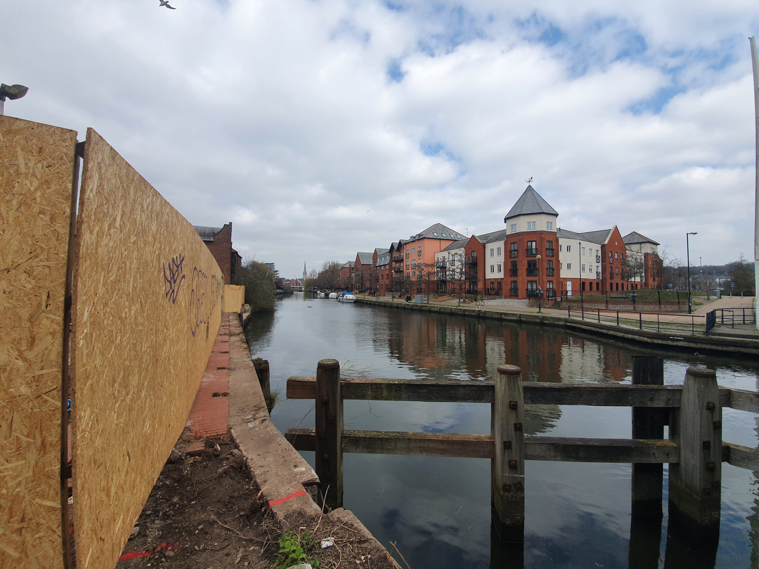
Moving away now from the Argyle Street area, this is Cannon Wharf which lies between the River Wensum and King Street. It retains the name of the previous building and it’s the final building in St. Julian’s parish before it becomes St. Peter Southgate parish. Norfolk Heritage Explorer notes:
“An excavation in 1997 discovered buried soils dating from the early Norman period, demonstrating that intrusive modern development has not destroyed the earliest archaeological deposits in this area. These deposits were overlain by a medieval stone building which may have been partly destroyed during Kett’s rebellion in 1549. Finds from the site include Late Saxon and medieval pottery and 12th century leather working debris. Excavation in 2007-2008 has also recovered evidence of revetment and deposits laid in order to raise the level of the foreshore of the River Wensum in the 11th-13th centuries, as well as the possible remains of a landing stage. Later medieval and post medieval features included a flint boundary wall and further possible landing stages, and the remains of industrial buildings and services dating to the late 19th and 20th century were also uncovered.”

This is one of only two older buildings in this southern section of St. Julian’s Parish, known as Cannon Cottage.

The cottage is now used for holiday lets, which is a shame as it would have made for a nice residential property.

The frontage onto King Street, although the interior has been heavily changed. The building was heavily restored to ensure that it survived and I like that it has been kept, at least something of a constant in an area that has nearly all been bulldozed.

The original building date of 1847 is visible.

The fenced off area is likely because there’s a hot tub in there and they didn’t want people watching from the bridge.

Norwich is twinned with Novi Sad in Serbia and this bridge was named after that connection.

The bridge is for pedestrians and cyclists only and not for road traffic (I approve), having opened in 2001. Constructed by May Gurney at a total cost of £800,000 it’s apparently an asymmetric cable stayed swing footbridge, which probably means more to my friend Liam (who is currently building a bridge, or more likely drinking tea thinking about building a bridge).

There’s foot access to the Wensum by the side of the bridge, looking left towards Norwich Riverside.

And looking right towards Carrow Road, which is Norwich City’s football ground.

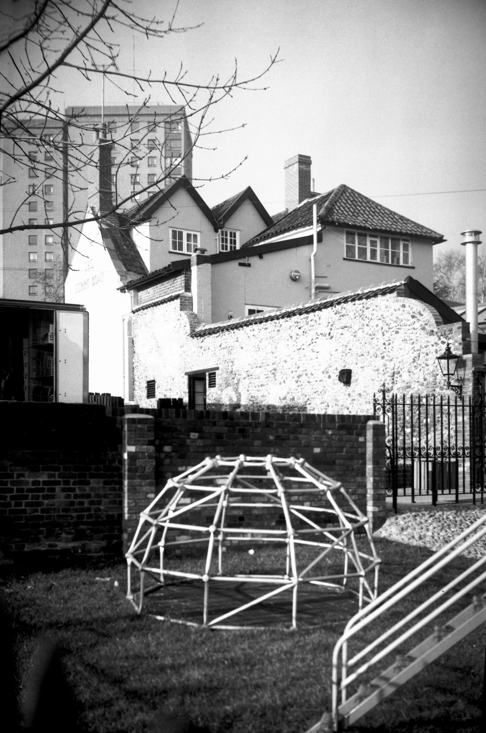
This has been the scene of much controversy and delay over recent years, the former car park of the Ferry Boat Inn in Norwich. The former Greene King pub shut a few years ago, meaning that every pub along the main part of King Street has now been shut down, with a new project called King’s Bank now underway here. This project means the structure of the pub will remain, but it won’t be used as a licensed premises, instead the site will have 41 homes on it.

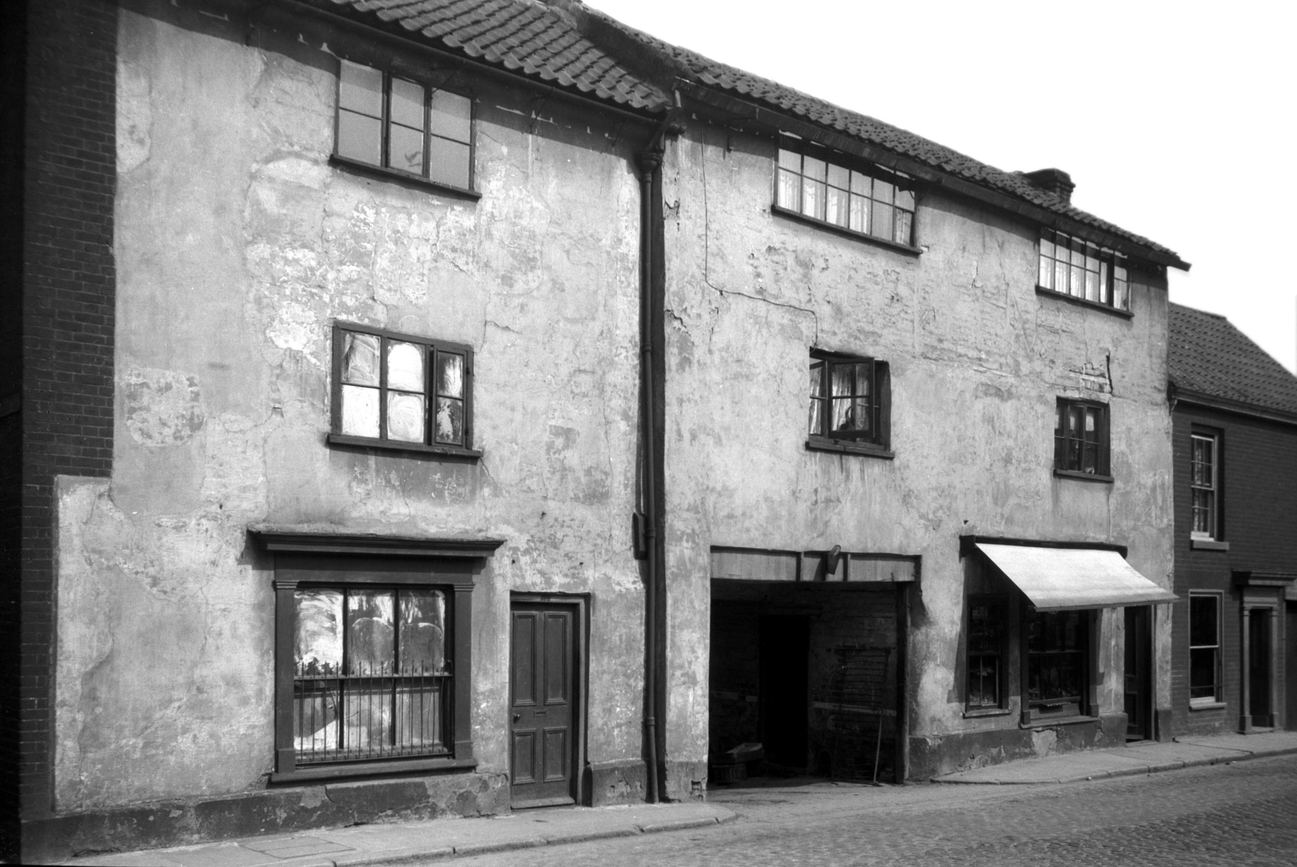
This is the former line of King Street, there’s now a junction here with Rouen Road on the left and King Street on the right. This is roughly where 195 to 197 King Street stood, a not particularly exciting building which George Plunkett photographed in 1936.

The side of the Ferry Boat Inn, George Plunkett took a photo here in 1936 and he also has one from behind the pub dating from 1987. There’s a photo from AA King of this area from the 1940s, although taken from the other direction to my photo.

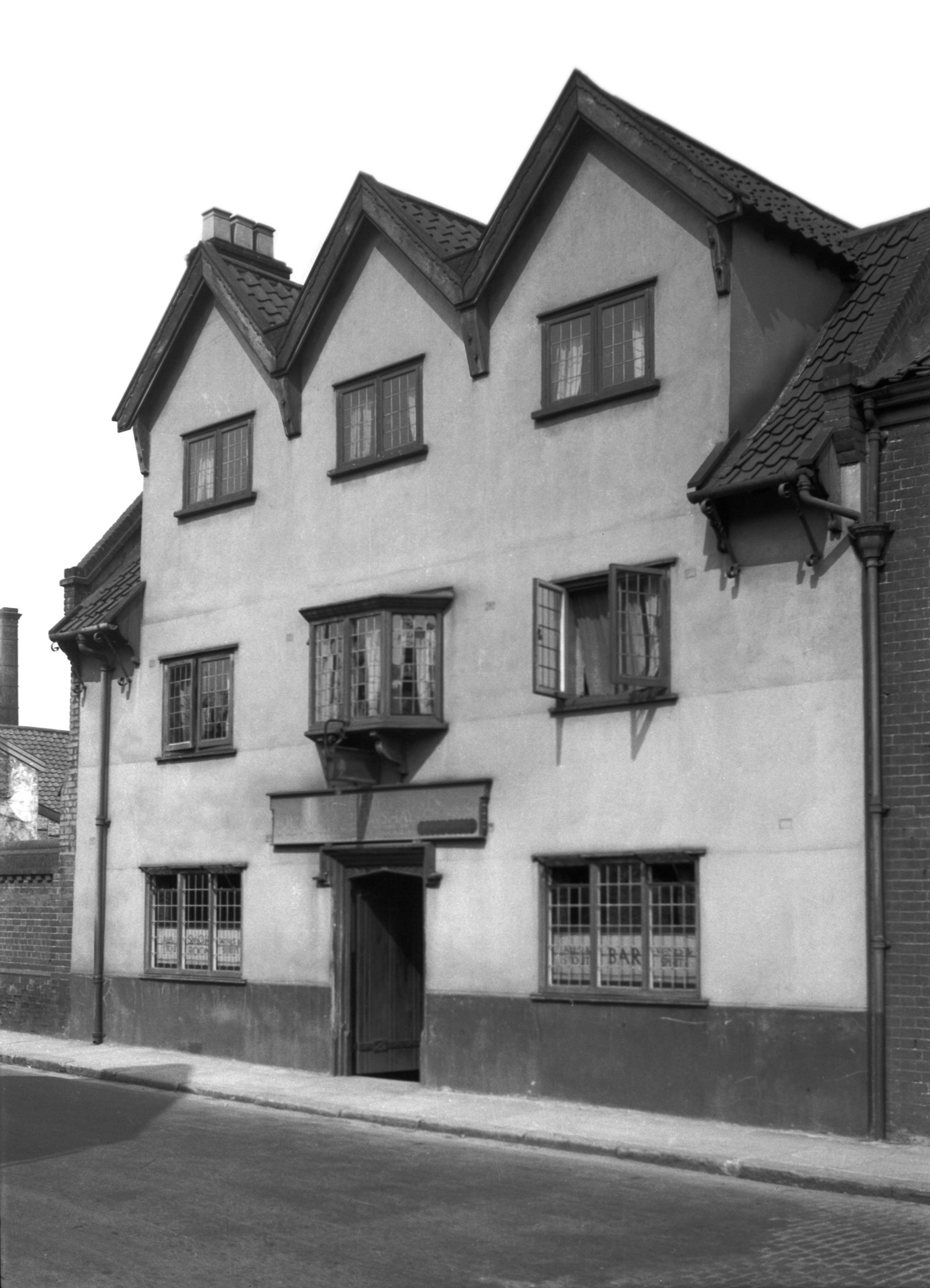
And the pub itself, which is the only other building that survives in this part of the parish. It open as a licensed premises in the middle of the nineteenth century and closed, initially temporarily, in 2006. For a while in 1988 the pub’s landlord was Steve Wright, the Ipswich mass murderer. It’s a shame that this won’t continue to be a pub, as it once occupied something of an enviable river position.


