Norwich History by Parish : St. Etheldreda
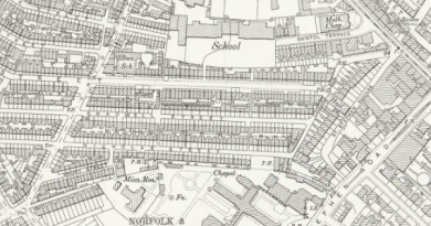
And a new little project that Jonathan and I are undertaking because this lockdown is clearly here for at least a few more weeks. It’s a bit niche (our project I mean, not the lockdown), I’ll accept that, but there we go. Effectively, it’s walking around Norwich, ancient parish by ancient parish and seeing what is there now compared to a map from the 1880s (the map above is from 1789, but the one from the 1880s is more detailed, which is why we used that). There’s a PDF of these boundaries to provide some extra background to this whole project.
St. Etheldreda is the seventh parish we’ve visited and is one of the smallest in terms of its physical size. When we started this parish I had wondered whether there would be much of interest, as great swathes of it have been destroyed and replaced with modern housing. However, some elements remain and it was a suitably intriguing challenge to work out where the roads once were in relation to where we were standing.
As for the destruction of much of this parish, which was partly pre-war slum clearance, partly air raid damage but mostly post-war clearances. It’s easy to be critical of the council that they destroyed so much history, but that should be tempered with the situation that they had residents needing decent housing, they had war-damaged properties and also poor quality housing. It’s too simplistic perhaps to just condemn the council for bull-dozing history given the limitations that they had.
However, even after noting that, I personally think that the council made substantial mistakes with this huge rezoning. They retained little, with most streetlines being lost and the heritage they could have saved was just bulldozed away. There was all manner of local opposition and numerous historic buildings were lost, despite the hopes of locals that they could be saved. The council by all accounts disregarded these attempts to save elements of the area, which is perhaps a great shame.
So it all means that there is no anchor to the past, they created a new community that feels a little separate from Norwich city centre, despite it being a very short walk away. The council demolished Mariners Lane which connected King Street to Ber Street and broke the direct link between the two areas. Instead, they ploughed a new street, Rouen Road, through the middle of what was once housing which now has several car parks and under-used sites along it.
It appears from the media that the reason that the council did this was because they initially expected the site to be entirely reused, even as a university site, although the University of East Anglia were attracted by more spacious surroundings outside the city centre. This would therefore make more sense in terms of demolishing the area, although perhaps the council might have got clarity on that before tearing everything down.
The EDP has a photo of what this area looked like in the early 1960s, and that street heading down to the middle of the photo is Mariners Lane.
And here is that same location today, Mariners Lane, which is now a cul-de-sac leading off from Ber Street. This is in St. John De Sepulchre parish though, so we mostly ignored this today.
This photo is taken at the base of the hill, looking at Normandie Tower, which is I think the only tower block in Norwich City Centre. I initially thought that this piece of hill was original, but it isn’t, this is where Mariners Lane came down.
This photo is taken in the same place as the previous one, but facing the other way and looking at Rouen Road.
Clicking on the above map makes it bigger. I was standing on the final T of “William Street” on the map when taking the photos, with Normandie Tower being pretty much on top of Compass Street.
Now standing on Rouen Road at what appears to be some sort of temporary bus station that First have created for themselves, with Normandie Tower in the background.
This is the route of Mariners Lane, now demolished here.
This photo is taken in (nearly) the same place as that taken by George Plunkett in 1935. On his photo, it’s possible to see the sign for the Congregational Mission Hall at Sherbourne Place where services took place on Sunday evenings at 19:00. This has now been demolished, as have all of the malthouses which stood along here.
This is where the malthouses once stood. The buildings on the right are the rear of the properties fronting onto King Street. The council tore down many buildings along King Street, but on numerous occasions there was local opposition which ensured that the properties were maintained. Although King Street might have lost some of its history, it hasn’t been decimated.
This is the church from which the parish takes its name, a now redundant (in religious terms) Grade I listed building which dates from the twelfth century, with additions made in the fourteenth century and a substantial Victorian restoration. It’s now in use by an arts organisation and I’ve been inside on a heritage day weekend, I’ll retrieve my photos from that weekend at some point.
The churchyard is in quite a state in numerous different ways, not least because some of these littered about the place.
The Norman style doorway, which is actually probably Norman……
A photo taken from the grounds of Normandie Tower, looking back into the churchyard.
The church, looking quite pretty here. The roof was thatched until the Victorian restoration.
Something doesn’t feel right about this being here, I’m wondering whether this has been moved from inside the church. It might have been on top of a box tomb, but I’m not convinced this was its original placement.
A broken stone in the churchyard.
The north side of the church.
I am still yet to be convinced that using gravestones as some sort of garden feature is appropriate or respectful. Others may have different views.
This is the end of the parish, and the Ferry Boat Inn is at the rear, across the parish border. And an explanation of that, the parish of St. Julian’s is located both to the north and south of the St. Etheldreda parish, it’s a strange split. Anyway, somewhere on the left the Rainbow pub stood until 1959, which backed onto the parish boundary.
This car park is on the former site of the Crown Brewery, which occupied a large site along the river from the early nineteenth century. The National Archives note that “the Crown Brewery was gradually acquired by the firm of brewers known variously as Baseley, Youngs and Roe, Youngs and Burt, Crawshay and Youngs, and Crawshay, Youngs and Youngs, in the years” and it closed in the middle of the twentieth century. A few of the buildings from that period survive and the brewery also owned the Music House building, more of which later on in this post.
Photos from the Crown Brewery site, with the River Wensum visible.
Some decoration in the foliage.
A mural on the wall, with some not ideally placed bins. I understand that this was designed by Walter Kershaw in 1984 and it features numerous elements of Norwich’s history. The mural is on the reverse of the building, so it’s not visible from King Street itself.
The buildings on the right, 176-178 King Street, are also visible in George Plunkett’s photo from 1936.
This is the former Ship pub and another loss, in my opinion, to King Street as this would have made for a quite marvellous licensed premises. George Plunkett yet again helps me here, this is the pub in 1939 and the EDP have one from a not dissimilar period.
Not only will I link to George Plunkett’s marvellous photos, I shall also quote his text about this:
“The yard to its south has at some time been partly built over, so that while formerly wide enough for the passage of carts it will now accommodate only pedestrians. The finely carved lintel above bears a design of foliage together with the rather contradictory inscription “Princes In”; it is believed that this was brought here at some time from the famous inn of that name, first mentioned in 1391, which once stood in St George Tombland parish on the north side of Princes Street”
It’s also quite visible in this photo just how the width has been narrowed.
The old name of the yard.
Inside the yard, which is blocked at the end and there’s nothing older behind these buildings, it’s all been demolished.
The old entrance to the Ship Inn, which ceased being a licensed premises in 1969.
Wooo!!! Some survivors on the outside of the pub, with our parish of St Etheldreda on the left hand one from 1786. The two on the right both relate to the parish of St. Julian (the J was once used more interchangeably with the I) but in two different formats, one from 1800 and the other from 1825.
On the other side of the road from the Ship Inn is 167 King Street, or the Music House. This is also on the edge of the parish boundary and some of this structure dates to the twelfth century. The undercroft is now Jurnet’s Bar and is full of character and history, taking its name from a man known as Jurnet the Jew, who purchased the building from John Curry in 1225. Once a house for the wealthy, this area became a little less glamorous over time, so the building was split up into tenements in the eighteenth century. It is the only non secular building from the twelfth century to survive in Norwich and it’s used today by Norfolk County Council. Behind here was the Crown Brewery, who owned the building for much of the nineteenth and early twentieth centuries.
These parish boundary markers are on the Music House, with the parish of St. Julian off towards the left of this photo and this has markers from 1789 and 1825, with the marker for St. Etheldreda dating to 1786. I like that one of these iron parish boundary markers was placed here in the year of the French Revolution, that’s a quite remarkable survival really given everything else that has changed in this area.
And a look back down towards the parish of St. Etheldreda, a really quite fascinating section of street.


