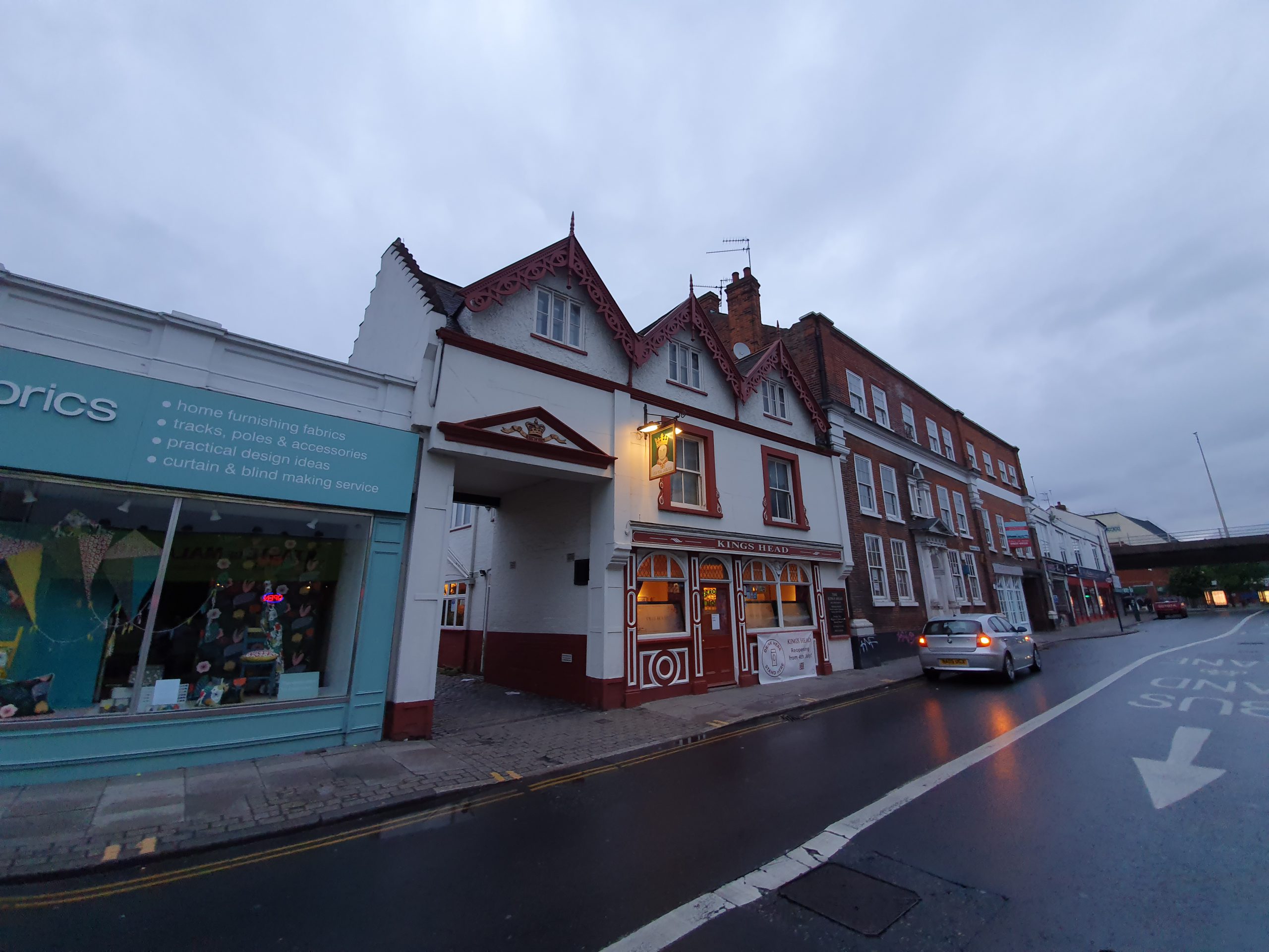
Category: Norwich

  • Norwich – Blackfriars Bridge

    Norwich – Blackfriars Bridge

    There has been a bridge across the Wensum River at this site since St Margaret Newebrigge was constructed in 1289. It was replaced with a stone bridge in 1587 and then a more substantial stone bridge in 1783. This latter bridge was needed as the previous construction had three narrow arches which was causing problems with the current of the river. The bridge is also sometimes known as St. George’s Bridge, and in the past, New Bridge.

    File:Blackfriars Bridge Norwich.JPG

    I didn’t take a photo of the actual bridge, but this is the one from Wikipedia until I do take one….. The current bridge is the 1783 bridge, built by John de Carle, designed by Sir John Soane and made with Portland stone with iron balustrades on the side.

    Photo: © Sir John Soane’s Museum, London, and there are some more images at http://collections.soane.org/OBJECT1804. This is Soane’s design and at the bottom right is the signature of John de Carle, the local builder. The bridge cost £1,250 and the design means that the stones are tightened together by use of the iron clamps.

    This bridge was only fully pedestrianised a few years ago, although there was once a separate iron footbridge on one side which was removed in the 1970s when single direction traffic only was implemented.

    The bridge was one of the earlier constructions designed by Soane, who is better known today for designing the Bank of England, although there’s not much left of his work there. Soane put in a design for the Hellesdon Bridge in 1785, clearly hopeful after the success of the Blackfriars Bridge, but the design by James Frost was chosen instead.

    The view to the east from the bridge, the building to the right is the Norwich University of the Arts.

    And a view to the west, with the building to the left also being part of the Norwich University of the Arts and Dukes Palace Wharf behind that.

  • Norwich – Line of River Cockey

    Norwich – Line of River Cockey


    Located at the top end of Westlegate is this stone marker which notes the former route of the Great Cockey river, but also mentioning the now lost Muspole, Dalymond and Freshflete rivers in Norwich.

    The blue stones start at the marker and then head off down Westlegate. The river once started at what is now All Saints Green, which is at the end of Westlegate, down Westlegate and then flowed down under Bedford Street and joined the Wensum River opposite where Norwich Playhouse is located today.

    Flowing down….

    There’s the site of the former McDonald’s on the right-hand side, and the blue carries on to the lower end of Westlegate. I hope that road reconstruction doesn’t cause chunks of the blue to go missing over the next few years, as it’s a rather lovely idea. There was a small nearby river, called the Little Cockey, which ran pretty much parallel, but didn’t join the Great Cockey.

  • Streets of Norwich – Haymarket (East Side)

    Streets of Norwich – Haymarket (East Side)

    Part of my Streets of Norwich project….

    I’ve already posted about Haymarket, but there are some buildings on the east side which are of particular interest.

    The Haymarket Chambers building, designed by the local architect George Skipper. Now one of the two Pret outlets in the city, it was previously used by Snob, a clothing retailer.

    Looking down towards the Market Place, the rest of Haymarket is on the left-hand side of this photo.

    The entrance to the Lamb Inn, which is one of the oldest pubs in the city and some argue that it might be the second oldest in Norwich (the Adam and Eve on Bishopgate dates back to the mid-thirteenth century).

    The original part of the Primark building, once used by BHS when they were in the city.

    The new Primark extension on the left, which has been open for a few months. Well, it’s shut now with the virus, but, other than that….. The archaeological report from that process is an interesting read as well. There was no real loss with the building they pulled down, a bland modern affair, which was used by Wallis and Dorothy Perkins.

    This is number 3/4 Haymarket, now used by Fatface, but it has a substantial heritage and it retains its fifteenth century undercroft. I haven’t yet got to go on one, but there are tours of the building as part of the Heritage Open Days Weekends (and there’s a series of photos on-line at http://www.oldcity.org.uk/norwich/tours/curathouse/index.php). There are still oak panelled rooms inside from when this was a residential property, lived in at one stage by John Curat in the sixteenth century, with the building now often referred to as Curat’s House.

  • Norwich – Bell Pub Re-Opening

    Norwich – Bell Pub Re-Opening

    Unfortunately, rather than this being about the pub’s opening after the lockdown, this post relates to the re-opening of the Bell pub in 2017, when they had just completed a major refurbishment. This saw one of the downstairs seating areas removed and turned into toilets, some of the former hotel rooms (long before Wetherspoon operated the location) being turned in seating space and the closure of the second floor toilets.

    The pub was open only for training purposes, with every visitor allowed a free meal and two drinks.

    The training menu.

    The information sheet given to customers.

    The food I ordered, the half chicken and chips, with coleslaw and peri peri sauce. Unfortunately, Wetherspoons don’t sell this any more. Or indeed the pastrami bagel, but I won’t start about that again.

    The new part of the pub, which I think is in the former hotel bedrooms as the windows suggest a series of smaller rooms. More recently, this area was used by the bank below for offices.

    The same room as above, but looking the other way.

    A long seating area and looking back into the same room as in the above two photos.

    I liked this area, as there are power points along here, but last year they removed the seats, I assume to give staff better access. Shame though, it was a quiet area to sit.

    One of the booths, complete with power points, USB chargers and a dimmer for the light.

    Another view of the new area of the pub.

    And the outdoors seating area.

    The trial opening was all very smooth, the food and drink was served as expected and I was particularly delighted at the very cheap price of free….. Although it gave the pub more seats, it still isn’t enough as it’s hard to get a seat at lunch-time such is its popularity. I have no idea when it’ll re-open after the virus, but I imagine it’ll be popular again soon enough.

  • Norwich – Wagamama

    Norwich – Wagamama

    This post circulating on Facebook reminded me that I haven’t posted much about wagamama in Norwich. Incidentally, the correct answer is Greggs, JD Wetherspoon (despite their boss) and wagamama……

    Anyway, back to a Norwich before the virus….

    wagamama freshly made juices do have a richness of flavour, but they don’t always look the most amazing.

    My usual dishes in wagamama are firecracker chicken and chicken katsu (and perhaps the tori kara age as a starter), but this is the spicy bream donburi which I think only usually appears as a special. And, beautiful fish which was tender and soft, with a heap of pea sprouts which added texture. Slightly hidden away in the photo are the shredded carrots and rice, with a side of kimchee sort of visible at the back of the photo.

    Seating in wagamama can be a little bit communal and, despite the slightly highly prices, it usually seems busy. It’s one of those restaurant chains which doesn’t have a huge amount of competition, unless the seemingly endless number of Italian dining options. The food usually arriving at different time is usually the cause of complaints at the restaurant, with the service being perhaps their strongest element.

    This is all making me hungry again, but I’m sure that wagamama will be back open soon….

  • Streets of Norwich – Redwell Street

    Streets of Norwich – Redwell Street

    Part of my Streets of Norwich project….

    Redwell Street today doesn’t quite make sense, it goes from Princes Street at the top of the above map, down to Queen Street, which is where Brewdog is located.

    Redwell Street makes more sense in this map from the 1880s, as some buildings were demolished to allow for St. Andrew’s Street to be extended, allowing trams to use the road. This cut Redwell Street in two and the lower half is really now part of St. Andrew’s Street in terms of the road layout.

    The street used to be known as St. Michael’s Street, because of St. Michael-at-Plea Church which is located here. In the seventeenth century a pump was added to an existing well by the church, which likely had a red covering and surround, and it became known as Red Well Street. That, over time, became corrupted into the current name of Redwell Street.

    This is Boardman House, which has a Redwell Street address, but its frontage and a connected building is on Princes Street, so more on that another time.

    Not much of huge historic interest here, although the building on the far right is 8 Redwell Street, which retains its nineteenth century frontage.

    The building on the right-hand side was built in 1957 for the Norfolk News Company, sadly demolishing a fair chunk of its heritage during the process. Given that the first provincial newspaper was published here at the beginning of the eighteenth century, it’s a shame that there’s nothing more than a plaque to mark the event.

    This is the building to the right-hand side of Jackson-Stops, the entrance to Clement Court.

    The signs show where Bank Plain and Redwell Street meet. The building on the right is interesting, this is 2 Redwell Street, which has a fifteenth century undercroft. The shopfront is original from the nineteenth century and the undercroft and cellars project underneath the Redwell Street pavement.

  • Norwich – Romani DNA

    Norwich – Romani DNA

    This is the sign on the back of the Castle Quarter (or Castle Mall as I’m still calling it), opposite the Woolpack pub. It notes a discovery in the 1990s during the Castle Mall development when archaeologists excavated what transpired to be an eleventh century graveyard. It was important as it found Romani DNA, which is much earlier than anything else that had been discovered in the British Isles, around 500 years earlier than previous evidence.

    There were 118 dental extractions from 59 skeletons which were sampled during the 1990s, although the results weren’t published until 2006. They took the DNA from tooth pulp, as the enamel on the teeth had helped to preserve it. Those buried had been Saxon Christian and the original report noted:

    “If the rare TA haplotype found in ancient Britain instead suggests the presence of people of Romani ancestry in tenth century England, this is in surprising contradiction to historical evidence indicating that the Romani first left India—as mercenary soldiers or camp followers—at around AD 1000 (Hancock 2002). Some suggest that emigration from India could have been as early as the sixth century (Fraser 1992; Hancock 2002), and others have proposed much earlier routes via Egypt (see Kendrick 2000), but these theories are much less well supported.

    One possible explanation would be if Romani women were enslaved by Vikings during trade expeditions to the Byzantine Empire, or formed liaisons with them during common association in Varangian army camps (in Byzantium) in the ninth and tenth centuries (Graham-Campbell 1994; Hancock 2002). These associations could also have been with Anglo Saxons, though known associations of Anglo Saxons with Varangian camps began only in the late eleventh century (Hancock 2002; Shepard 1973). Second generation Varangians are also known to have returned north (Hannestad 1970), and the mtDNA haplotype could have been introduced in this way. The gravesite at Norwich is typical of late Saxon, Christian sites with no grave goods and an east–west orientation, but this does not necessarily exclude Norse burial (Hadley 2002), and Viking artefacts were found nearby.”

  • Streets of Norwich – Church Alley

    Streets of Norwich – Church Alley

    Part of my Streets of Norwich project….

    Church Alley is a small street, or well, alley, which is located off Redwell Street and is behind St. Michael-at-Plea Church.

    On the left is Boardman House, which I have some internal photos of somewhere as I toured this on a Heritage Open Days weekend a couple of years ago. On the far left, not really visible in the photo, is the rear of the United Reform Church. On the right is St. Michael-at-Plea Church and it’s possible in theory to walk down this alley and through another courtyard, coming out on Tombland (I resisted on this occasion given the Coronavirus situation).

    The road goes between the old Sunday School (now Boardman House) and the church, with the boot and shoe manufactory now demolished. On a side note, the word manufactory used to be a common word for a factory, but it’s pretty archaic now.

  • Streets of Norwich – Chalk Hill Road

    Streets of Norwich – Chalk Hill Road

    Part of my Streets of Norwich project….

    Chalk Hill Road is located roughly between the S and V of Wensum, going from the river and meeting Rosary Road in this 1830 map.

    By the 1880s, the street still didn’t exist, it is located just on the bend of Rosary Road, behind Aspland House.

    The street today, which was built at the end of the nineteenth century, looking towards the Wensum River.

    Looking back to 1939, the register of the street revealed:

    1 – Vacant

    2 – Bullock household

    3 – Anderson household

    4 – Morter household

    5 – Vacant

    6 – Vacant

    7 – Vacant

    8 – Nutt household

    9 – Ducker household

    10 – Holdstock household

    11 – Sadler household

    12 – Nickalls household

    13 – Lynes household

    14 – England household

    15 – Wilson household

    16 – Woodrow household

    17 – Sexton household

    18 – Hannant household

    19 – Knowles household

    20 – Westland household

    21 – Fisher household

    22 – Frostick household

    23 – Rudd household

    24 – Wright household

    25 – Bridgens household

    26 – Vacant

    27 – Jermy household

    28 – Norton household

    29 – Reeve household

    30 – Cooper household

    31 – Rumball household

    32 – Hill household

    33 – Howes household

    34 – White household

    35 – Benison household

    36 – Amers household

    37 – Coombs household

  • Streets of Norwich – Clement Court

    Streets of Norwich – Clement Court

    Part of my Streets of Norwich project….

    There’s not much history left in Clement Court, but it does still exist behind the locked gates and the street name by its entrance remains.

    One of the most important pieces of history here is that Francis Burges published the first English provincial newspaper on 6 September 1701, the Norwich Post. The newspaper was published between 1701 and 1713, although unfortunately the earliest surviving copy is from 1707.

    This map from the 1880s shows that there was a Plymouth Brethren meeting room in the court, which could seat 260 people. The buildings around the court were mostly destroyed in 1957 when the Norfolk News Company extended their premises.