Blog

  • London – British Museum (Norwich Triumphal Arch etching by Paul Fourdrinier)

    London – British Museum (Norwich Triumphal Arch etching by Paul Fourdrinier)

    I usually visit the British Museum three or four times a year, something which is a little difficult to do with the current virus situation, primarily because it’s shut. However, they’ve placed hundreds of thousands of images on their web-site, so this will have to do me for the moment. The images can be used non-commercially, as long as the British Museum is credited. So, this is their credit.

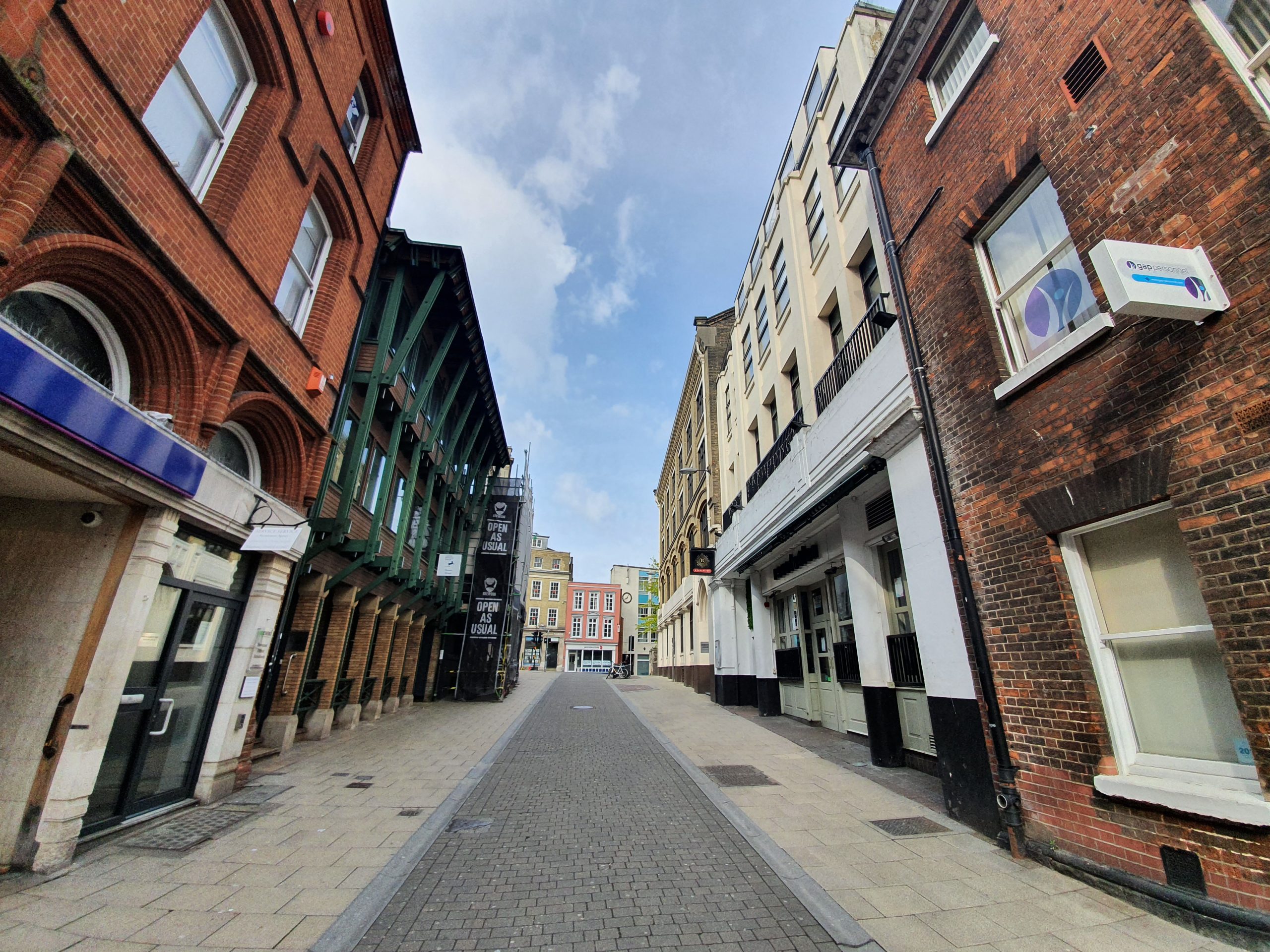
    When I was in Bucharest a few weeks ago I was quite impressed by the number of triumphal arches they had, which marked victory in some conflict or other. I wondered briefly, as to be honest I wonder about a lot of bloody rubbish, why no enterprising man or woman had bunged something up in Norwich. They were often only temporary structures, so a bit of wood, bit of decoration and there’s a lovely arch.

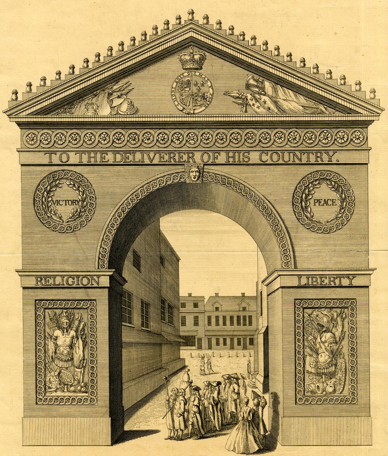
    I digress. Again. So, this plate above is etched by Paul Fourdrinier, an engraver and etcher who lived between 1698 and 1758, who kept himself busy by doing the illustrations for books, as well as being a portrait painter. The British Museum noted that this scene is in Norwich and being naturally sceptical, I did wonder whether that was right. But, of course, the curators were right and I found a similar etching which does have Norwich written on it.

    The arch was erected in honour of the Duke of Cumberland in 1746 and it had the phrase “to the deliverer of his country”. My rickety knowledge of history means this is the Battle of Culloden, where the Duke of Cumberland put down the Jacobite Rising. So, the next question is where on earth in Norwich was this arch put up? After reading through old newspapers, it seems there were triumphal arches placed in the city centre on a regular basis between around 1700 to 1850, usually at the marketplace. And then, I noted on Wikipedia, there’s a reference to the exact spot being by the Guildhall. I still can’t pin down exactly where the buildings in the above etching are, but I can now sleep at night with my new knowledge of triumphal arches in Norwich. I really need to get out more.

    And you can’t see the etching at the British Museum, it’s not on display.

  • Streets of Norwich – St. John Maddermarket

    Streets of Norwich – St. John Maddermarket

    Part of my Streets of Norwich project….

    For some reason that I’ve never fathomed out, I’ve always liked this street, which is dominated by St. John the Baptist, Maddermarket Church and its sprawling churchyard. The name of the street is derived from the time that madder, which is a root that produced a red dye, was sold from the north end of the churchyard in the thirteenth century. From then on, the name has stuck and this street connects St. Andrew’s Street with Pottergate. More on the church in another post though…..

    The building on the left is number 21-23, two buildings constructed in the seventeenth century which have been two separate shops for some time, with the left-hand side property having once been a pub.

    I’ve been intrigued by this graveyard on the right-hand side, as it’s raised up and I know that in York and in other cities this was simply because they kept trying to put burials in the space they had, and the ground level rose. However, the church itself is also higher, because it was fitted into a limited amount of land. But, having written that, there was an archaeological dig which found bodies from the seventeenth century underneath now what is the above road, so the graveyard was once lower.

    I hadn’t noticed this until today, it’s a water pump from the nineteenth century which is made out of iron and is now missing its handle.

    A view down the street towards St. Andrew’s Street.

    Another thing that I haven’t noticed before, this notes where the Golden Lion public house was located between 1783 and 1965. It was also the location of Golden Lion yard, which was also swept away when the pub was demolished.

    This is where the pub was. Replaced by yet another bland and generic building. Although to be fair, there’s a photo of the pub here and it didn’t look that exciting either. But I prefer the look of the pub.

  • Dictionary of the Vulgar Tongue – Day Forty-Six

    Dictionary of the Vulgar Tongue – Day Forty-Six

    The Dictionary of the Vulgar Tongue was first published at the end of the eighteenth century, and given that the Coronavirus crisis is giving too much time to read books, I thought I’d pick a daily word from it until I got bored…..

    To Bubble

    This is defined as “to cheat”, terminology which seems relatively common in the seventeenth and eighteenth centuries, then lost in the nineteenth century. Bubble is a made up word, so it doesn’t have any Greek or Roman origins, with the dictionaries saying that it’s a word named after the sound of a bubble bursting. Which, I guess, is where the cheating thing comes from, their trust was burst just as a bubble would be.

  • Streets of Norwich – Rigbys Court

    Streets of Norwich – Rigbys Court

    Part of my Streets of Norwich project….

    Rigby’s Court, which is the small lane which leads from Bethel Street to St. Giles Street. There’s a small plaque (below) which is on the right-hand side property.

    The lane takes its name from Dr. Edward Rigby (1717-1821) who was the Mayor of Norwich in 1805 who lived in the building. As the plaque notes, “he was associated with the Norfolk and Norwich Hospital for fifty years from its foundation in 1771, and was responsible for introducing vaccination into the city”.

    There’s an opened up area along the lane, which are numbers 4-9. Number 4 was made a listed building in 1972, although I’m unsure why, it’s marked as being an early nineteenth century residential building that is now offices, of which Norwich has many…..

    The building on the left, number 3, is an early nineteenth century residential property which became a printers and looks like it’s back to being a residential property again.

    Not much has changed since the 1880s, although before 1850, it was known as Pitt Lane.

  • Streets of Norwich – Queen Street

    Streets of Norwich – Queen Street

    Part of my Streets of Norwich project….

    Queen Street is located off of Tombland and connects with Redwell Street. I’m omitting one building of interest on this street from this post, which is the Church of St. Mary the Less, which has an intriguing story of its own.

    This is the Old Bank of England Court. The building to the right-hand side of the court is a former residential property built in the late seventeenth century, which is now used as offices. It is also where the offices of Edward Boardman were once located, a well-known (well, locally, I don’t think he was an international superstar in the nineteenth century) Norwich architect. The building to the left-hand side of the court is similar in once being residential, although was first built in the early eighteenth century.

    The name of the court is because the Bank of England had offices here between 1826 and 1852, a regional location to try and bring some stability to the country’s banks, which had gone through a period of instability. They gave up with that idea in the 1850s, which the Bank of England operations being centralised back in London.

    This is handy at the Boardman Building at the Bank of England Court (which is a different location to the nearby Boardman House), the history of a building on a panel at the front. More places should do this.

    Looking back down Queen Street towards the Ethelbert Gateway, with the Church of St. Mary the Less visible on the left-hand side.

    The building on the left is Seebohm House, the former Haldinstein’s Boot and Shoe Manufactory, which later became the Bally shoe factory.

    Another view of Seebohm House, with the large gateway.

    Norwich Brewdog, I wish it was open as usual…..

    Brewdog is at 1 Queen Street, which was built as a residential property in the late seventeenth century, although it retains its fifteenth century undercroft. It has been a licensed premises since the beginning of the twentieth century, with CAMRA noting that over the last few decades that it has traded as “Hideout, Knowhere, Noir, Indulge, Hogshead, City Ale & Wine Bar, Gundry Whites Cafe Bar, Drummonds and Whites”. And as I’ve learned to love Brewdog, so hopefully it’ll stay there for some time….

    Next to Brewdog is the Bank of Scotland at number 3 Queen Street, which also has a fifteenth century undercroft.

    This is now Revolución de Cuba, which is the sister bar to Revolution, which is located over the road. I remember this as Yates, although it has been a Slug and Lettuce.

  • Random Posts – Randoms

    Random Posts – Randoms

    In what world is six sweets one serving?!?!

  • London – British Museum (Norwich Cathedral by John Sell Cotman)

    London – British Museum (Norwich Cathedral by John Sell Cotman)

    I usually visit the British Museum three or four times a year, something which is a little difficult to do with the current virus situation, primarily because it’s shut. However, they’ve placed hundreds of thousands of images on their web-site, so this will have to do me for the moment. The images can be used non-commercially, as long as the British Museum is credited. So, this is their credit.

    The British Museum purchased this sketch by John Sell Cotman from the collector James Reeve (1833-1920) in 1902 although it’s not currently on display. Reeve had purchased it in 1862 when a collection of Cotman works were sold at the Bazaar Rooms in Norwich.

    That’s a photo from pretty much the same spot today. The British Museum refer to this as a drawing of Norwich Castle, although I’m not convinced, that’s definitely Norwich Cathedral. Cotman lived near here for a while, on St. Martin’s Plain, which is at the end of Bishopgate. I like the idea that artists have been sitting in this spot by the river for centuries painting the Cathedral, and that the fields (now part of Norwich School) are still there.

  • Dictionary of the Vulgar Tongue – Day Forty-Five

    Dictionary of the Vulgar Tongue – Day Forty-Five

    The Dictionary of the Vulgar Tongue was first published at the end of the eighteenth century, and given that the Coronavirus crisis is giving too much time to read books, I thought I’d pick a daily word from it until I got bored…..

    Bub

    This is defined by the dictionary as “a strong beer”, and a couple of dictionaries say that the word derived from the sound of drinking. I’m not entirely convinced….. Sometimes the definition is a little different, such as “an alcoholic malt liquor”. There is a phrase that is “bub and grub”, but I think that derives from champagne, or a bubbly drink, rather than its archaic meaning. It is though perhaps where the second half of the word syllabub comes from.

  • London – British Museum (Cloth Seal)

    London – British Museum (Cloth Seal)

    I usually visit the British Museum three or four times a year, something which is a little difficult to do with the current virus situation, primarily because it’s shut. However, they’ve placed hundreds of thousands of images on their web-site, so this will have to do me for the moment. The images can be used non-commercially, as long as the British Museum is credited. So, this is their credit.

    I probably need to get out more given that I’m intrigued by an object in the British Museum that I’ve never seen and isn’t even on display there. But this is a cloth seal that was found in the River Thames, but it’s thought that it might have been made in Norwich by the Dutch immigrant community. Made out of lead, it would have secured clothing and the two holes are the rivet marks. The description of the seal is quite complex (by this, I mean I don’t understand it, although I’m not an expert in cloth seals to be fair), but it’s probably a portcullis.

    The seal was made in the late sixteenth or seventeenth century, but what is perhaps interesting is the size of the Dutch community in Norwich. It made up around 45% of the city’s population at one stage, but the community was welcomed in, despite their different language and culture. By all accounts that I’ve seen, the integration went well and the Dutch were welcomed and contributed financially to the city, which had been suffering a little economically.

  • Streets of Norwich – St. George’s Street (Colegate to Blackfriars Bridge)

    Streets of Norwich – St. George’s Street (Colegate to Blackfriars Bridge)

    Part of my Streets of Norwich project….

    St. George’s Street is a little complex as chunks of it have been renamed over the centuries and the route at the north has changed. And, it once wasn’t called St. George’s Street, it was instead known as Gildengate and it runs along the line of a Viking defensive ditch and bank which was constructed in around 900.

    As it’s such a long street, this post is just the section between Colegate and Blackfriars Bridge. Moderately surprisingly for such an historic street, there’s only one listed building in this section of road, suggesting how much the buildings have been mauled about and demolished over the last couple of centuries. This section of the street was probably more often known as Bridge Street in the nineteenth century, rather than St. George’s Street.

    This was historically a built-up area of the street, but is now St. George’s Green. Near to the river, the Blackfriars Tavern was a pub which traded between the mid-eighteenth century until its final closure in 1911. It was also known as the Cellar House and the Friars Tavern, and probably overlooked the river.

    Norwich Playhouse, which is housed in what was built as a nineteenth century maltings building, which became a theatre in 1995. This former building is set back a little, with the roadside section once taken by the Crown public house, which closed in 1928.

    A former shop, now used as offices. Somewhere behind these buildings there was a pub known as the Cork Cutters Arms, which was a licensed premises between around the early 1860s until 1898.

    Cafe Pure on the right-hand side.

    The Last Wine Bar on the left. Somewhere on the left-hand side of the photo was the Two Quarts pub, which traded between the 1760s and was closed down in 1907. It sounds like a pub of some considerable character and it had rooms to rent.

    The building to the left, numbers 25, 27 and 29, are the only listed properties on this section of the street. They date to the sixteenth century, which were added to in the eighteenth and nineteenth centuries, although the shopfronts are from the nineteenth and twentieth centuries. The frontages of the buildings have been heavily restored, the photos George Plunkett took in the 1930s show much more character. Although the buildings would have probably fallen down if they weren’t restored…. Number 25 was a cafe for quite a period, run by Alfred and Emily Aldridge in the late 1930s and all of 25-29 is now By Appointment, which I think was a cafe and is now a hotel.