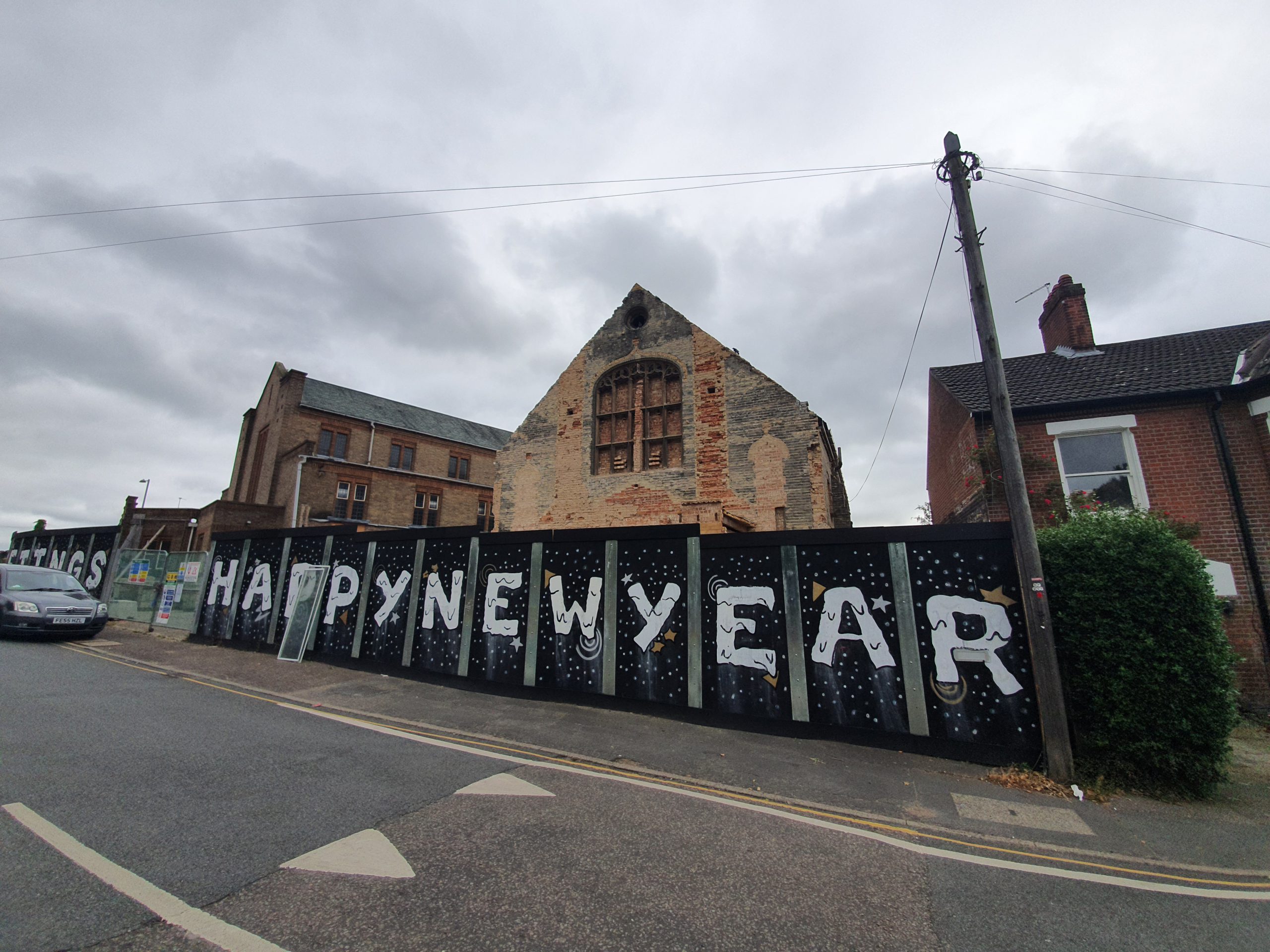
Tag: Norwich

  • Norwich – Name Origin

    Norwich – Name Origin

    Since I’ve been merrily writing about the name origins of numerous villages around Norfolk, it perhaps makes sense to mention the county’s major city. No, not Dereham, it’s Norwich.

    The Concise Oxford Dictionary comments on the origins:

    Norwich, Norfolk. Norowic in 930, Noruic in Domesday Book. North Town.

    This is one of the book’s shorter definitions and Norvic is still used today, not least by the Bishop of Norwich who signs off with this title. The explanation, as the book says, is simple, it just means North Town, so that makes this blog post nice and easy….. The Saxon ‘wich’ meaning settlement or town is relatively frequently seen, including at Ipswich, Harwich, Greenwich and so on.

  • The Stone Bridge at Horse Fair

    The Stone Bridge at Horse Fair

    I posted earlier about how the Norfolk and Norwich Archaeological Society have made back issues of their journal available on-line. Meandering through a few issues, the Reverend W. Hudson wrote in 1884 about the stone bridge at Horse Fair. He noted:

    “Of the hundreds who in the course of a year make their way from Prince of Wales Road by St. Faith’s Lane into the Lower Close, probably nearly all could at once call to mind the old wall which skirts the road on their left; but scarcely one, perhaps, is aware that if he keeps close to the wall, at a point not far from where the wall bends round towards the open space called the Horse Fair, the ground is hollow under his feet, and he is in fact crossing over a bridge which once spanned a dyke which passed under the road”.

    Over 135 years later, that road layout hasn’t changed and I’m one of no doubt many who wasn’t aware of this bridge either.

    The full-sized map is visible by clicking on the above image, and I had no idea there was once a bridge here. Prince of Wales Road had just been laid out at that stage, hence why it’s pencilled in.

    The full article is available at https://archaeologydataservice.ac.uk/library/browse/details.xhtml?recordId=3236503.

  • Norwich – Meadows Near the River Yare

    Norwich – Meadows Near the River Yare

    Just photos, but this is the meadow area between Trowse and Whitlingham Lake, just by the River Yare. I’ve never walked on these meadows, although they were peaceful and there were a few small groups sitting by the river.

    Not the most welcoming of introductions though.

  • Norwich – Colman’s

    Norwich – Colman’s

    Last week, Unilever closed the Carrow Works factory that has been used by its Colman’s brand since 1856, marking the end of the connection with Norwich.

    I noticed that the Colman’s branding has been removed from the site now, with production mostly moving to Germany. I have no idea what they’re going to do with the huge site, although there are some listed buildings within the complex, so it’ll likely be turned into housing. Some of the site is currently available for short-term let, although I’m not sure who would want such a large site for 18 months.

  • London – British Museum (Postwick Grove, Norwich)

    London – British Museum (Postwick Grove, Norwich)

    I usually visit the British Museum three or four times a year, something which is a little difficult to do with the current virus situation, primarily because it’s shut. However, they’ve placed hundreds of thousands of images on their web-site, so this will have to do me for the moment. The images can be used non-commercially, as long as the British Museum is credited. So, this is their credit.

    I like this print which is in the collections of the British Museum as it’s painted at Postwick Grove. I’d never heard of this place until we walked through it on Saturday, but it’s a once quiet area of the city where painters would come and be inspired by the peace and countryside. These painters would have also walked the similar route to the one we did on our 22-mile walk (more on that soon), although they didn’t have to cross the Norwich Southern Bypass.

    The print was produced by John Sell Cotman and there’s no precise production date, just sometime between the dates of 1813 and 1838. Handily the museum knows that it’s from before 1838 as Cotman included it in a book which he produced in that year, the ‘Liber Studiorum – A Series of Sketches and Studies’ published by HG Bohn. The print isn’t on display in the museum and was acquired by them in 1902 from James Reeve, a long-time custodian of the Norwich Castle Museum.

    This is what the artists would have seen at Postwick Grove, with the railway line to Reedham and Great Yarmouth to the top of the image, but it’s missing the huge dual carriageway which now ploughs vertically through the area. The addition of the Norwich Park and Ride parking area hasn’t done much for the peace and quiet either, but there is still an element of tranquility left.

  • Streets of Norwich – St. John’s Street

    Streets of Norwich – St. John’s Street

    Part of my Streets of Norwich project….

    There’s not much to write about St. John’s Street, which is located off of Mountergate. The current St. John’s Street used to be called Orchard Street (named after the Orchard Tavern pub), and the rest of it has since been lost to development.

    The buildings that were either side of what was Orchard Street have also gone, with car parking on the right-hand side and Parmentergate Court housing project on the left-hand side.

  • Streets of Norwich – St. Martin at Palace Plain

    Streets of Norwich – St. Martin at Palace Plain

    Part of my Streets of Norwich project….

    I’ve realised today how little bloody attention I pay to things, given that I’ve been calling a road I thought that I knew by the wrong name. It’s only a marginal error, but I’m moderately irritated that I hadn’t realised, Bishopgate ends earlier than I thought and becomes St. Martin at Palace Plain. Now, this is hardly of much relevance to anything of global importance, but the quirky layout is due to how things have shifted over the last century.

    In the above map, St. Martin at Palace Plain covers part of the square, then the road down to where it looks like there is a pub in the middle of the road, before going up to another pub. Today, that is the entrance to the courts and the road and Worldsend Lane have all gone, so St. Martin at Palace Plain is effectively just the stump of road between the church and the entrance to the Bishop’s Great Gate and not that much further. Indeed, I’ve noticed that some properties have been moved out of St. Martin at Palace Plain on the listed buildings register and placed under other streets.

    But, despite this street now just being a bit of a stump, it has a tremendous amount of history packed into it.

    This is the view from the end of St. Martin at Palace Plain, looking down towards Bishopgate.

    The sun gave me problems taking this photo, but this is the Bishop’s Gate, a structure constructed in 1436 to give access to the Bishop’s Palace. I’ve been in the chapels at the top of the Erpingham Gate and the Ethelbert Gate, but I don’t know what the set-up is with this one. The old Bishop’s Palace is now used by Norwich School, but there’s a new palace used by the bishop which is just the other side of this gate.

    This is St. Martin’s Church, which has spent its lifetime literally overshadowed by the cathedral. No longer really having any congregation of its own as the nearby housing had gone, the church stopped being used for services in 1971. Since then it has been used to store church furniture, as offices for the Probation Service and is now used by the Norwich Historic Churches Trust. More on this in another post as I’ve been on a guided tour of this church, and it’s one of my favourites in the city.

    This was once the wall of the Bishop’s Palace, although there has been some building just inside of it over the last century.

    On the wall in the previous photo is this plaque, which marks where Lord Sheffield was killed during Kett’s Rebellion in August 1549.

    The Kett’s Rebellion was started by the desire of some landowners to enclose land for their own financial benefit. That’s a slightly shortened version of the enclosure process, but that’s the upshot of it. The locals didn’t like that, so on 8 July 1549 some denizens at Wymondham ripped up the landowners’ lovely new fences. The owner of the manor of Wymondham was Robert Kett, who should have been most aggrieved at the damage done to property. But, he decided to back the rebels and he became their leader.

    Kett decided that he would march on Norwich to show the authorities that the locals weren’t happy and that it was the poorest who would suffer the most. Perhaps unfortunately for him, he had thousands of people with him, turning a little local dispute into one of the largest protest marches that East Anglia had ever seen. He reached Bowthorpe, a suburb of Norwich today, on 9 July 1549 and Sir Edmund Wyndham, the Sheriff of Norwich, popped out to tell Kett that he should perhaps go home. Kett ignored that.

    Instead of going home, Kett led his men to set up camp at Mousehold Heath, on the edges of the city centre, on 12 July 1549. Although this location was outside of the city walls, it offered views into Norwich and this is where they established their camp for six weeks whilst issuing their demands for a fairer society. By now, there were 16,000 people at this camp, which was presenting a problem for Norwich, as although it was the second-largest city in the country at the time, it still only had a population of 12,000.

    The authorities agreed to listen to the demands that Kett had, which took some time, as there were 29 grievances that Kett wanted dealing with. Some of these were fiercely ambitious and only one related to the enclosure process, which is what had started this all off. During this time, the city hadn’t closed off its gates, so the people at the camp could enter Norwich to buy food and supplies, with something of a party atmosphere going on at Mousehold Heath by all accounts.

    On 21 July 1549, the city authorities got fed up with this and they shut the gates. Faced with the camp having to break up due to a lack of supplies, Kett led an attack on the city. Despite having a strong artillery and city defences, Kett’s rebel forces won and took control of the city. This was a serious threat to King Edward VI now, so he ordered 1,500 troops led by the Marquess of Northampton to retake Norwich.

    The relevance of this story to the street I’m writing about is that one of the military leaders was Lord Sheffield. He had had what I assume was a lovely breakfast at the Maid’s Head, a hotel which is still trading today, and led a mounted attack on rebels to force them back along St. Martin’s at Palace Plain to Bishopgate and then back out of the city. Unfortunately, he fell off his horse into a ditch. The rules of engagement at the time said that in such circumstances, the fallen man should be taken and held for ransom. Unfortunately for Lord Sheffield, a butcher decided to hit him on the head and kill him. And, today the location of Lord Sheffield’s death is marked by the plaque on the wall.

    Just to finish the tale, the rebels could never win this, the Monarch was too strong. He despatched the Earl of Warwick and 14,000 men, including some rather rough mercenaries, to take back control (there’s a phrase….) and after a series of battles, the rebels lost. Although the Earl of Warwick’s army lost 250 men, there were over 3,000 rebels killed during the fighting. Many surviving rebels were promptly executed and Robert Kett and his brother William were taken to the Tower of London to face trial. They were, unsurprisingly really, found guilty and Robert Kett was sent back to Norwich to be hanged on the walls of Norwich Castle, whilst his brother was hanged on the west tower of Wymondham Abbey.

    Was the rebel sacrifice worthwhile? Probably not. Little changed, other than the city announced it would mark a day of celebration every year on 27 August to celebrate the defeat of the rebels, with this party carrying on for well over a century.

    Anyway, after that story, back to St. Martin’s at Palace Plain. The other building that is now situated off this road is the modern court complex, which has one of the city’s oldest buildings in its cellar, the Norman House. But more of this when I find those photos….

  • Streets of Norwich – Wherry Road

    Streets of Norwich – Wherry Road

    Part of my Streets of Norwich project….

    Wherry Road, named after the type of boat that carried cargo along the River Wensum, is a relatively new road which isn’t visible at all on the above map from 1900. It starts from the middle of where the Goods Station once stood, then goes down parallel to the river before following the route where it says “allotment gardens” and then stops where I’ve put the cursor, which is now Koblenz Avenue.

    At some point in the mid-twentieth century, a road was placed alongside the river, which in turn was ripped up in around 1999 when work on the Riverside retail complex started. The main road was rerouted to the new Koblenz Avenue and Wherry Road was formed, a mainly pedestrian road.

    Wherry Road from the railway station end, so I’m now standing on where the goods shed used to be. As an aside, back in the day, the goods shed was bigger than the main passenger terminal at Norwich railway station.

    The mural above Frankie & Benny’s. As another entirely random aside, before the Covid-19 situation, I was pretty much deluged from various sources with ridiculous discounts of getting up to 60% off from this restaurant. I always felt sorry for people who just walked into the restaurant thinking they were going to get a decent meal, perhaps spending money that they didn’t have as a birthday treat, without realising that the owners were giving huge discounts to nearly every other diner. I’d be surprised if the chain survives in its current form, but that’s a matter for another day.

    This photo was taken on a Bank Holiday Sunday, it’s not quite what the business owners down here must have been expecting. TGI Fridays on the right, I’m still missing their unlimited appetisers.

    Las Iguanas on the left, JD Wetherspoons on the right.

    Hollywood Bowl on the left, the Odeon ahead and Nando’s and Las Iguanas on the right. All deadly quiet….

    I’m not sure how well these buildings were constructed, but I’m not sure that they have a long life ahead of them. Riverside has quite a pleasant vibe generally, and is usually busy on most evenings, with a large car park for those who like that sort of thing.

    The entrance to Lady Julian Bridge.

    The Queen of Iceni, which is a JD Wetherspoon outlet, named after Boudicca. There was a railway track which reached to pretty much exactly where the pub’s front door is now.

    The rear of the Odeon cinema on the left, as the area now becomes residential.

    Leading onto Albion Way to the left.

    The Novi Sad Friendship Bridge, and a new housing development alongside it.

    And looking towards the end of Wherry Road, with a leisure centre on the right and ahead is Carrow Road, Norwich City’s football ground. This is the area that was previously allotment gardens, so no doubt it was once quite serene and peaceful.

    And, that’s Wherry Road, not the most of intriguing locations in terms of history as it’s all around twenty years old, even the two bridges are newly constructed within that time.

  • Streets of Norwich – Lady Julian Bridge

    Streets of Norwich – Lady Julian Bridge

    Part of my Streets of Norwich project….

    Lady Julian Bridge, which is a pretty decent name for a river crossing, is a little difficult to place on an old map, such as the one above from 1900, as so much of the landscape has changed. It connects Old Barge Yard (which is still there today) on the left bank across to some railway building on the right bank, with a cursor I’ve carefully placed marking where it goes over the River Wensum.

    The entrance from Riverside, with the bridge taking pedestrians and cyclists over the river. The bridge cost £2.5 million and during the construction phase, it was called the Old Barge Yard Bridge.

    Looking back at the bridge, again from the Riverside side. The bridge is named after Lady Julian, an anchoress in a nearby church, which still sort of stands (it was rebuilt thanks to a bombing during the Second World War) who lived in the fourteenth century. She also wrote the first book by a woman which was written in English and she’s still in print, not a bad little effort.

    The bridge was constructed in 2009 and it’s a swing bridge, as there is still a need for boat movements along this stretch of the river. There were over 200 entries submitted in 2008 as to what the bridge should be called, with around 40 of them suggesting a theme around Julian of Norwich. I remember submitting an entry of what I thought it should be called, but this ridiculously wasn’t chosen. I won’t say what it was…..

  • Streets of Norwich – Cathedral Street

    Streets of Norwich – Cathedral Street

    Part of my Streets of Norwich project….

    Cathedral Street leads from Prince of Wales Road to St. Faith’s Road and Horse Fair. It hasn’t changed much since the 1880s map, just the building of some houses which cover the empty space at the top-left side of the street.

    But, all of this development was relatively new at that time, as in this 1830s map it’s evident that Prince of Wales Road and Cathedral Street didn’t even exist. Prince of Wales Road was constructed to be a sweeping boulevard to the new railway station and Cathedral Street was laid out at the same time.

    Looking down from the Prince of Wales Road end, towards one of the entrances to the Cathedral Close. The buildings on the left-hand side are numbers 4, 6 and 8 Cathedral Street and by the 1930s they had been merged and turned into a hotel. In 1939, the hotel owners were Frederick Bryant and his wife, Kate Bryant. They’re all still one unit and have been jointly converted into flats with a substantial rear building added onto them.

    This has been, for at least twenty years, a Chinese restaurant, but it was previously the Duke of Connaught public house. The pub opened in the 1860s and it closed in around the 1970s, when it was converted into a restaurant.

    The properties at 4, 6 and 8 Cathedral Street mentioned above are on the left-hand side of this photo, then there’s a dentist at 10 Cathedral Street and an archway leading to the rear of the properties.

    Looking back towards Prince of Wales Road.