Category: UK

  • Norwich – Ron’s Fish and Chips

    Norwich – Ron’s Fish and Chips

    I haven’t been to Ron’s Fish and Chips on the market before, not least because I have been rather obsessed with Grosvenor for two decades. I visited a different chip shop on Norwich Market a few months ago and it was, to be honest, a really unimpressive effort from Norwich City Council who operate the market. There was near zero Covid-19 compliance and the chip shop (not Ron’s) in question was failing to operate with any care.

    The picture today was really very different, and everything feels very safe and well managed. The one-way system is in operation, individual units no longer have customers standing and eating there and everything seems clean and organised. A polite member of security staff was explaining that there is no eating anywhere near the stalls, customers need to take food just a short walk away. All very professional, I’m suitably impressed.

    Back to Ron’s. I’ve muttered and moaned (but not in a very grumpy manner….) about chip shops not taking cards, it’s just a faff to be forced to use cash. Ron’s isn’t one of those, they have a card machine (although I had come armed with coins just in case). They also have a very friendly member of staff serving, a clean operation and rather cheap prices. My battered sausage and chips came to £1.80, which I thought was really quite acceptable. The chips were hot and tasted sufficiently chip like for my needs (nice and firm on the exterior, fluffy inside and with plenty of smaller chips), with the batter on the sausage having some depth of flavour, I was again impressed.

    So, all told, this is now one of my favourite chip shop locations in Norwich. Which will mean I’ll have to pop back a few times, but I think I can manage that.

  • Attlebridge – St. Andrew’s Church

    Attlebridge – St. Andrew’s Church

    I quite like the Attlebridge village sign, it seems to suggest that the church is something similar to St Michael’s Mount, towering above the local countryside.

    And here it is, on top of its own hill. But, it’s Norfolk, so I suppose that is quite high. Anyway, Attlebridge was a very different place fifty years ago, the main road to Fakenham thundered by in front of the church and it was a short walk to the nearby railway station. Sadly, that’s gone, with the Marriott’s Way railway line swept away, although the village is likely pleased that a bypass has meant that cars no longer flood through the village.

    The church was first built here in what was likely the end of the eleventh century, but the nave was reconstructed in the thirteenth century. The porch is sixteenth century, but perhaps from before the Reformation. George Plunkett has a photo of how the church looked in 1939, taken just a couple of weeks before the outbreak of the Second World War.

    The north aisle visible above is fourteenth century. There is a stair turret on the side of the tower, although it only reaches the second stage. Some documentation provided in the church mentions that this was inaccessible by the early twentieth century and it was only reopened in 1984.

    The tower is thirteenth or fourteenth century, likely replacing a round tower from the eleventh century. The Victorians spent some money here as the church had become a little derelict by the middle of the nineteenth century, although the Norfolk Chronicle reports in 1903 that funds had been raised to deal with the “tower which has for some time been in a precarious position”.

    There’s a niche at the base of the tower that was perhaps previously a window.

    The Priest’s Door has been filled in, with some rather big lumps of flint, at some stage in the early nineteenth century.

    There some character here, with the old door and the niche on the left hand side.

    Located in that niche, this stone figure was found dumped in the river in the 1960s and it was thought that it might be from some form of religious structure, especially as it was nearby to a hermitage side. It is though likely from Attle Bridge, from which the village takes its name, which was reconstructed in 1913. Chances are a workman just thought the stone looked a bit old and dumped it in the river, so a rather less mystical history than might have been hoped for.

    The rather old door, I’m unsure of its age, although the arch of the door is likely from the fourteenth century rebuild. I’m still intrigued with the concept of just how many people have crossed the threshold of this door over the centuries, for all manner of weddings, funerals, baptisms and sermons.

    Ignoring the restorations of the Victorians, this still feels like a medieval church. Peaceful, slightly damp, and calm, time hasn’t much moved on here. Thanks to Campbell Wodehouse, the vicar here in the late 1850s, there were numerous talks relating to the RNLI, which at that stage was in its relative infancy. The Norfolk News reported in 1860 that the organisation wasn’t that well heard of inland, but Wodehouse had encouraged numerous churches to become involved with their good work.

    The chancel. I put my name in the visitor book, the first in a few months.

    The north aisle.

    The church tower which is blocked off, likely to prevent people meandering up the stairs.

    The church’s font, dating to 1866.

    I’m not entirely sure why the church has two fonts, this one is located at the entrance to the chancel.

    There would have been some rood stair arrangement in the wall here, but that’s a bit complex for me to work out….

    An archaeological dig took place in 1989 in the field just to the north of the church, which found evidence of Romano-British settlement. Since the church is on raised ground that would have surely been used, there must have been something located on the site of where the church is now getting on for perhaps not far off two millennia. That’s not a bad heritage to have.

  • London – Greenwich (Borough of) – National Maritime Museum (Nelson’s Death Coat)

    London – Greenwich (Borough of) – National Maritime Museum (Nelson’s Death Coat)

    This is “one of the most iconic items in our collections” the National Maritime Museum note, the uniform which Admiral Horatio Nelson was wearing when he died. Vice Admiral Nelson was killed on 21 October 1805 during the Battle of Trafalgar, when a bullet fired from the French ship Redoutable hit his left shoulder. The damage done was fatal and Nelson was aware of this immediately and he’s quoted as saying “Hardy, I do believe they have done it at last, my backbone is shot through”. He was carried off to get medical help, stopping en route whilst he gave advice to others whilst the battle continued, dying around three hours after he was injured.

    It was suggested to Nelson that he perhaps shouldn’t wear medals on board the ship as it made him stand out to the opposing forces, who could target him. However, removing them was a slight faff as they were sewn on and such was the inaccuracy of weaponry at this time, Nelson didn’t seem to fear much. The ones on display here are those which were on the coat when he died, but they themselves were replicas.

    It’s possible to see on the coat a hole where the bullet hit Nelson on the shoulder, making this a slightly grim exhibit, albeit one of national importance. There are also blood marks on the sleeve, which aren’t particularly visible, although it’s thought that these are likely that of Nelson’s secretary, John Scott, who had died about an hour before. Scott’s body’s had been thrown into the sea but blood remained on the deck and Nelson fell onto that spot when he was hit.

    The coat was given to Lady Emma Hamilton, who was Nelson’s mistress, but she was in a slight predicament that the Government excluded her from events, and her own husband wasn’t best pleased at this entire situation. She sold the coat in 1814 to help pay off some of her debts and it was later repurchased by Prince Albert, who gave it to Greenwich Hospital.

    Copyright of the Royal Collection Trust

    One of the joys of history is that most things entwine with each other, although that’s sort of literally the case here. The bullet which killed Nelson, along with bits of his coat that got caught up with it, are exhibited at the Queen’s Guard Chamber at Windsor Castle. It was taken from Nelson’s body by William Beatty, the doctor of HMS Victory, who decided that he quite fancied having a souvenir of the whole incident. He wore this locket for the rest of his life, but when he died his family donated it (probably with some relief) to Queen Victoria.

    As an aside, Nelson didn’t want his body chucking overboard as the usual way of getting rid of dead bodies. So, it was Beatty was put Nelson’s body in a barrel of brandy to preserve it whilst the ship set sail back for England. During this period of transportation the gases from the body forced the lid of the barrel off. It’s said that the sailors guarding the barrel were rather surprised by this occurrence….

  • London – Islington (Borough of) – Edward Johnston Memorial at Farringdon Station

    London – Islington (Borough of) – Edward Johnston Memorial at Farringdon Station

    Just in case anyone thinks I’ve started travelling again, these are photos from a very quiet Farringdon underground station last month. And this is the sort of slightly niche memorial that I like, a quite glorious addition to what would otherwise be a sterile corridor area. It’s also perhaps not really apparent what it is at first, I like a bit of depth to things such as this.

    The memorial was unveiled in 2019 and was designed by Fraser Muggeridge and it honours the work of Edward Johnston (1872-1944). Johnston was commissioned by Frank Pick to design a new typeface for the London Underground and it started to appear across the network in 1916. The London Underground roundel concept wasn’t designed by Johnston, but he was responsible for its design evolution and how it appears today. The London Transport Museum has more information about the roundel and Johnston’s influence on it.

    The typeface was initially planned to just be used on London Underground posters, but it was seen to be clean and tidy, so its use was extended to nearly all signage. This memorial has been designed to look like the printing blocks that were once used, hence why it looks back to front.

    As an aside, this memorial was unveiled by Sir Peter Hendy, someone who has a long interest in the fabric and heritage of transport in London. I remember when I was at an underground station in 2013 (I’ve forgotten which) where there was an issue where everyone needed to leave. I sought help from a staff member, and by chance I managed to get assistance from Hendy who was there offering customer service help. He knew exactly what buses I needed to get and had a formidable knowledge of the network, although I suppose that’s inevitable given that his career was spent in buses and he was heading TFL. Anyway, because I like to report excellent customer service to companies, I filled in the TFL customer service feedback form and I got an template e-mail back the next day that my positive comments had been forwarded onto the staff member……

  • Norwich – Rosary Cemetery (James Light)

    Norwich – Rosary Cemetery (James Light)

    Located at Rosary Cemetery in Norwich, this is the grave of James Light, who was born in Southampton in 1849, the son of Isaac Light and Lucy Light. Isaac and Lucy (nee Sillince) had married on 4 July 1847 in Southampton.

    At the 1851 census, James lived at St Faith’s Lane in Norwich with his parents, and they were lodging with another family. Isaac Light was an engine driver on the railways and he would have been one of the first to have that role in Norfolk, as the first line in the county was Yarmouth & Norwich Railway which opened in 1842. I’m not sure why the family made a move from Southampton, but perhaps it was so that Isaac could secure employment in this new industry.

    By the time of the 1861 census, James and his parents were living at Garden Street in the city, along with their other children, Emma, Richard and George. They had moved to Wilderness Place by 1871, with Isaac, Lucy, James, Richard and George living there. Isaac, James and Richard were all working for the railways and although I’m guessing here, I suspect they would have found this a more exciting job to have than some others which were available at the time (mostly shoe manufacture in Norwich). The railways were still relatively new and exciting, there must have been something of an element of adventure and a knowledge that the railway network was expanding.

    However, bad things were to take place. Whilst working as a fireman on the train, James died on 10 September 1874 at the age of 25 in what is known as the Thorpe rail accident. This incident, which took place near what is now known as the Rushcutters pub, caused the death of 25 people and over 75 others were injured. It occured when a mail train and a passenger train hit each other head on due to some confusion and poor communications. When the crash took place it was the second worst rail incident that had taken place in the country in terms of fatalities, with more people having died only at the Abergele rail crash of 1868. One of the legacies of this major incident at Thorpe was the introduction of the tablet system, to try and prevent head-on crashes.

    I’ve marked the scene of the crash on the above map from the 1920s, which was very close to the Rushcutters, although the pub was known as Thorpe Gardens at the time. The coroner at the time insisted during the trial that the phrase “railway accident” wasn’t to be used, it was to be referred to as “a railway collision”. Shortly after, he said “it is due to the public to know how this collision did happen, whether it was through carelessness or accident; though I am afraid we cannot bring it to the latter, for everything at present appears to contradict that”. It’s clear that the coroner didn’t intend to oversee a whitewash with his inquest.

    The saddest element was the identification of the dead. For James, this was done by his brother Richard, who said:

    “I live in Wilderness Place, King Street and I am a fireman. The deceased James Light was my brother. I have identified his body lying here. My brother was a fireman in the employ of the Great Eastern Railway Company. He was twenty-five years of age and lived at Wilderness Place”.

    This must have been a hugely emotional task for Richard to perform, especially as he had the same job on the railways as his brother.

  • Norwich – Bridewell Prison Door

    Norwich – Bridewell Prison Door

    And today’s post is about a door-frame. Content doesn’t get more interesting than this….. OK, it does, but I still like this door and I’ve only recently noticed that it exists.

    Perhaps the best description of this door is from George Plunkett, who noted:

    “Descending St Andrew’s Hill from London St, there is about halfway down on the left a wooden doorway thought to date from about 1490, the former entrance to the Bridewell. Its spandrels, carved to resemble foliage, support a large wooden grille enclosed within the doorframe. This grille, which in unglazed, is of Gothic design and consists of two large lights, each divided into four smaller ones by slender mullions which interlace at the top like tracery in a church window. Sadly two of these mullions have gone since the 1930s; in view of the extreme rarity of such a doorway one would like to see it sympathetically repaired and conserved to prolong its existence for a few more centuries.”

    And he’s quite right, he has a photo from 1935 and it shows that bits have gone missing since then, having previously managed to survive several centuries. And I’m not sure what that bloody awful box is doing to the left of the doorway, it hardly ignites a feeling of beauty and history.

    These Norwich Lanes tablets (or slabs, whatever they’re called) very often give details of where pubs once stood, but this is a handy reminder that this door was once the entrance to Bridewell Prison. And if this excitement about the door isn’t enough, here’s some more about the flint wall on the same building, with a bit more history about the prison. I think I need to get out more….

  • Norwich – St. Julian’s Church

    Norwich – St. Julian’s Church

    It’s not known who the church of St. Julian is named after, it could either be Julian the Hospitaller or Julian of Le Mans. I hope that it’s the former, as he’s the Patron Saint of travellers and he’s venerated in Malta, where there’s a town called St. Julian’s which is named after him. The church seem less convinced, they think it’s of Julian of Le Mans….. Anyway, I walked by here a couple of weeks ago and hadn’t realised it would be open, so I had a little meander inside.

    Much has changed from this nineteenth century map of the church, with St. Julian’s Alley now reached off of Rouen Road.

    The church was heavily restored between 1868 and 1870 under the supervision of Walter Emilius McCarthy. The chancel was reconstructed and there was some modernisation to the building, similar to what Victorians did to other churches across the country. Here though, the work was overdue as the church had been allowed to fall into a state of disrepair before the work was undertaken.

    Unfortunately, nearly all of what is visible today is a post-war reconstruction as the building was nearly entirely destroyed during the Second World War, on 27 June 1942. The church has been restored to mostly look like as it did before it fell, but the tower wasn’t restored to its original height. It was the only badly bomb damaged church in Norwich to be rebuilt, even though others had more structurally left standing. This is mostly, and indeed likely entirely, due to the connection with Mother Julian.

    One discovery which was made were the Saxon windows that had been covered up in later restorations and which have now been made visible again. One example in the main photo of the church’s frontage above is the small circular window which are likely late Saxon.

    The main doorway of the church, which needed to be repaired following the war damage. George Plunkett has, of course some marvellous pictures of the church before it was damaged, as well as during the restoration.

    1937 – church before war damage

    1946 – church reduced to rubble

    1952 – reconstruction of north side of church

    1962 – completed church after rebuild

    The nave of the church.

    The chancel of the church.

    The church’s font was originally located at All Saints’ Church in the city.

    This door is from the nearby St. Michael at Thorn Church which was also damaged during the Second World War, but despite the tower remaining, the whole building was pulled down. The site is now used as the EDP’s car park and although I understand that there was a problem with the high number of churches already being under-used in Norwich, not keeping at least the tower was I think a mistake. But there was a desire to entirely redevelop that area of the city, something not really done that well in my view and it would have preferable to at least keep the streetlines.

    The door is though quite marvellous, it dates from the first half of the twelfth century and it’s now the entrance into the chapel of Julian of Norwich.

    This is the chapel of St. Julian, which is where Julian of Norwich was an anchoress where she lived in total seclusion whilst praying and writing. This chapel is a new addition, there were some foundations found during the excavations of the church following the war damage and it was thought they might have been from Julian’s cell. It was thought appropriate to build a chapel on those foundations, and I must say this is a gloriously peaceful little room.

    She has the honour of being the first known woman in England to have written a book, known as the Revelations of Divine Love (of which much more on Wikipedia). There’s also more about Julian of Norwich at the church’s web-site.

  • Norwich – Rosary Cemetery (George Johns)

    Norwich – Rosary Cemetery (George Johns)

    This is the gravestone of George Johns, located in the Rosary Cemetery in Norwich. George was born in Ludham in 1833, the son of John Johns, who was an innkeeper. George trained as a carpenter, but for reasons unknown, perhaps by necessity or in search of adventure, he decided to embark on a new career in the military.

    George joined the Royal Regiment of the Horse Guards on 9 October 1862, at the age of 31. His army records show that he was 6 foot tall (well, 5 foot 11 and 3/8 inches which seems ridiculously precise to me) and had brown hair. His service record seems a bit patchy, and there’s an absence without leave in there.

    George, who by now had retired from the army, married Lydia Bond, who was 12 years younger than him, on 22 October 1874. Eugene had already been born on 16 December 1870, which is perhaps the reason that George thought he’d better request to leave the army.

    At the 1881 census, George was living with Lydia and his 10 year old son Eugene at 3 Chester Place in Norwich. This road still exists, it’s located off of Earlham Road, near to the Roman Catholic Cathedral. Indeed, when George and his family were living here, work would have been taking place to demolish the Norwich City Gaol which was on the site to replace it with the Cathedral.

    The three family members were also living in the same location in 1891, with George still working as a starch maker and Eugene was now working as a shoe maker. I do wonder what someone like Eugene would have been doing today, perhaps a computer programmer or working in finance, there would be plenty of choice. For men in the late nineteenth century in Norwich, the choice was often limited to work in the shoe trade.

    George died on 19 May 1892, at the age of 59 years old and Lydia, George’s wife, died on 25 May 1922.

    Eugene married Kate and at the 1901 census, he was living with her at 12 Patteson Road, along with their children Harry, Hilda, George and Ivy. Eugene is listed on the 1939 register, by this time retired from the shoe industry, living with his wife Kate at 45 Midland Street in Norwich. Eugene’s home on Midland Street was only a two or three minute walk from where he had lived at Chester Place for many years. Eugene died in 1959, at the age of 89.

  • Norwich – Rosary Cemetery (Arthur Thomas Woodard)

    Norwich – Rosary Cemetery (Arthur Thomas Woodard)

    Arthur Thomas Woodard was born on 6 June 1873, the son of John and Charlotte Woodard. He was baptised at St John de Sepulchre Church in Norwich on 27 August 1879.

    At the 1881 census, Arthur was living with his parents at Brown’s Yard, off St. Stephen’s Street in Norwich. Later renamed Mansfield Court, this was all swept away with the post-war widening of St. Stephen’s Street. Arthur’s father John was working for the railways, and Arthur had numerous siblings also living in the same property, namely William, Elizabeth, Robert, Jemima and Mary Ann.

    Arthur served in the Royal Navy on HMS Abdiel and his service number was 350238. HMS Abdiel was a minelayer which launched in October 1915 and it laid 6,293 mines during the course of the First World War.

    Arthur died on 10 March 1918, at the age of 45. Arthur was a 2nd class sick berth steward and although the ship was involved in dangerous military action, his death followed a heart attack he had on board. Arthur’s job title sounds like it was something akin to a cruise ship, but here it’s just the rank for what is better known today as medical assistants. The ranks were, from more junior to senior, 1st & 2nd class boys, sick berth attendant, sick berth attendant 2nd class, sick berth attendant 1st class and chief sick berth steward.

    At the time of his death, Arthur’s parents were living at 11 Thorn Lane in the city and his father had to sign this letter to confirm the details of what they wanted on their son’s grave. I can’t quite imagine the emotions that parents and loved ones went through when sending these forms back to the Imperial War Graves Commission. It’s nice though to see that someone is still tending his grave, with Arthur being one of 31 Commonwealth War Graves at the cemetery.

  • Norwich History by Parish : St. Helen’s

    Norwich History by Parish : St. Helen’s

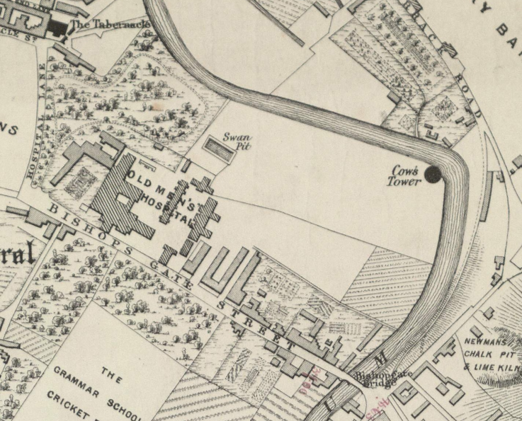
    And a new little project that Jonathan and I are undertaking because this lockdown is clearly here for at least a few more weeks. It’s a bit niche (our project I mean, not the lockdown), I’ll accept that, but there we go. Effectively, it’s walking around Norwich, ancient parish by ancient parish and seeing what is there now compared to a map from the 1880s (the map above is from 1789, but the one from the 1880s is more detailed, which is why we used that). There’s a PDF of these boundaries to provide some extra background to this whole project.

    So, starting our expedition, this is Bishopgate Bridge and three parish boundaries (St. Helen’s, St Mary in the Marsh and Thorpe) merge on this structure. Work on the bridge started in 1340 and a gate was added to protect the city soon afterwards, although that part of the structure was removed in 1790. Originally the bridge was owned and managed by the priory, but it became the responsibility of the city from 1393. The above photo looks down Bishopgate, the parish we were interested in today covers only the right hand side of this road.

    The Red Lion pub, which closed in January 2020, but which is expected to open again under a new leaseholder when the current lockdown is over. This building is from the 1870s, but there was a previous pub on this site called the Green Dragon.

    This is now the car park of the Red Lion, but it once had a number of houses on, some of which were near to the river.

    This part of the river bank of the Wensum doesn’t appear to have been built on, although that metal structure to the right is likely the supporting part of the bank from the houses that once stood there.

    The next stretch of the riverside path was once used as some form of allotments or vegetable gardens by the Great Hospital. It’s unlikely that there were ever any buildings here, it’s just a little higher than other sections of the riverbank, so might have been less liable to flood.

    This area, which is partly flooded now, was used for grazing livestock and was probably useless for most other purposes.

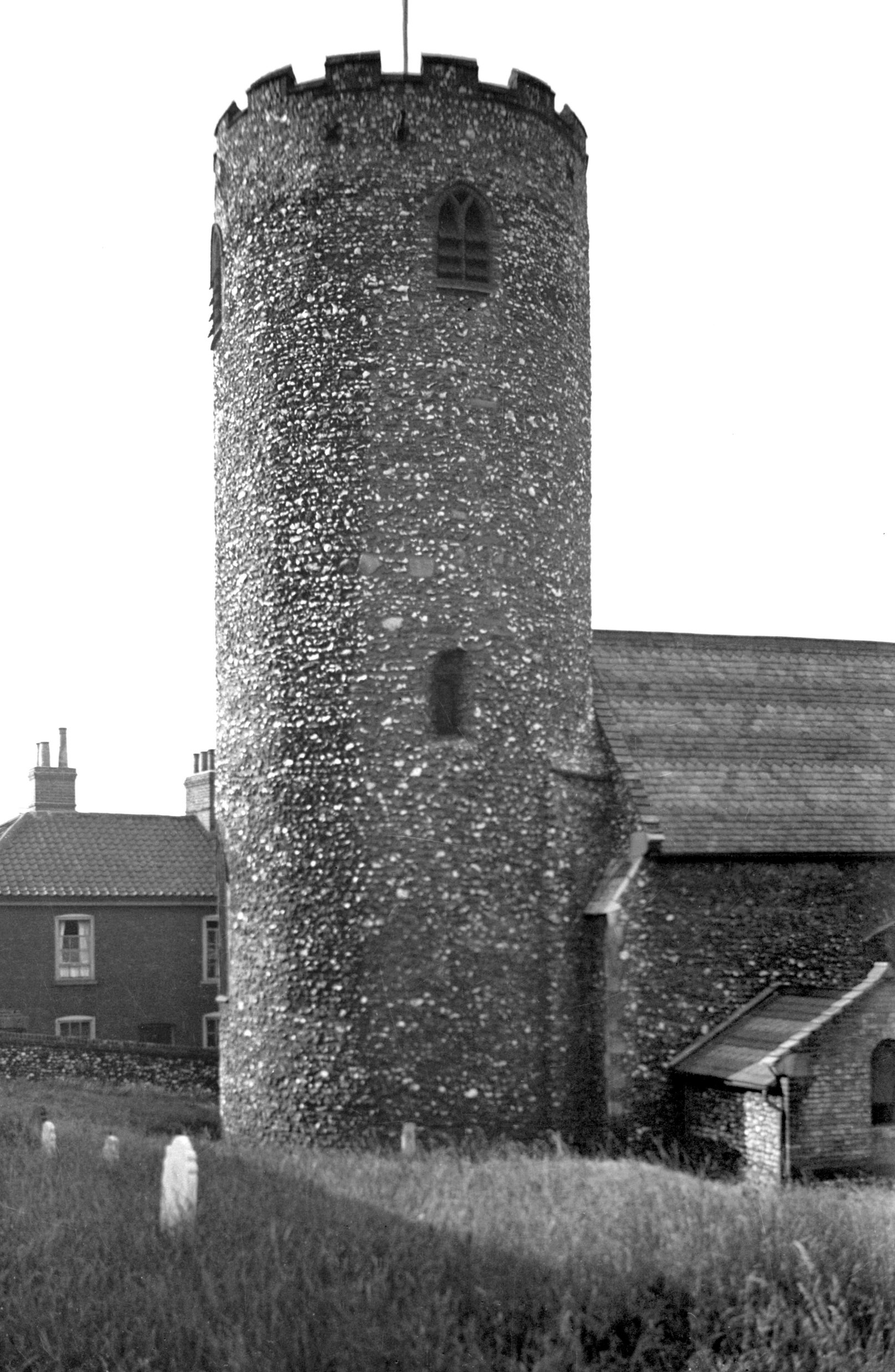
    And here is Cow Tower, and its name is from the cows which once grazed here. There have been some structural issues from the moist land that it sits on, but I think it’s done pretty well to have survived several centuries.

    The tower was built between 1398 and 1399, used to defend against foreign invasion and local troublemakers. The latter caused the city some problems during Kett’s Rebellion in 1549, and the structure was damaged during that time.

    The stairs that go up to the higher parts of the tower, which is all inaccessible now since the floors have collapsed. Much was demolished during the late eighteenth century, including many city walls and towers, but this survived. This was perhaps as it came under the care of the Great Hospital, who had no real need to demolish it. The building was patched up in the nineteenth century, but this was done by sloppy civil engineers and they caused large cracks to appear by their use of modern cement.

    I had never noticed this art project by London Fieldworks before, designed to be occupied by birds and insects, it was installed here in 2011.

    The next stretch of the River Wensum, again, this has never been built on and has likely only ever been used for grazing. All of this land was in the care of the Great Hospital, so nothing in this section got developed in the way that it might otherwise have done.

    This is the entrance to the swan pit, which isn’t accessible to the general public at the moment. The whole situation here seems complex, and a member of the public added some comments as I was reading out what it said on Wikipedia (spoiler, the woman disagreed a bit with Wikipedia). I’m not a swan expert, but there appear to be two elements to all of this.

    Cygnets (baby swans) were in Norwich owned by a number of different people, so they would be nicked on their beak to identify who owned which one. It seems that this meant that when they were older, and more grown up swans, the owner of the swan could be identified (swan upping is a tradition that still exists). Also, at the same time, the swan pit allowed swans to grow whilst being fed grain and not dirty muddy water, so they were forced into staying in a small area. When the swan was all grown up, it was killed and eaten (more information on this at https://en.wikipedia.org/wiki/Swan_pit). But, Joe Mason has much about this at https://joemasonspage.wordpress.com/2013/01/10/the-swan-pit/.

    A hole has been punched through this wall more recently, but this was the end of the Great Hospital’s estate, which went down to the river.

    The next section of land is now a car park (and it does seem that it could perhaps be better used for something else), but this was used in the nineteenth and early twentieth centuries as a timber yard. The wall on the right hand side (which contained a religious building that Jonathan and I didn’t realise was there – but more on this in another post as it’s outside the parish boundary) is now the courts complex.

    The Adam and Eve pub is one of two licensed premises within the parish, although there were in the 1880s four pubs in St Helen’s. This might be the oldest pub in the city and would have been frequented by those who were building and maintaining Norwich Cathedral. It was certainly in existence in the 1240s, but is likely older. The current structure dates to the seventeenth century, although there is a Saxon well under one of the bars.

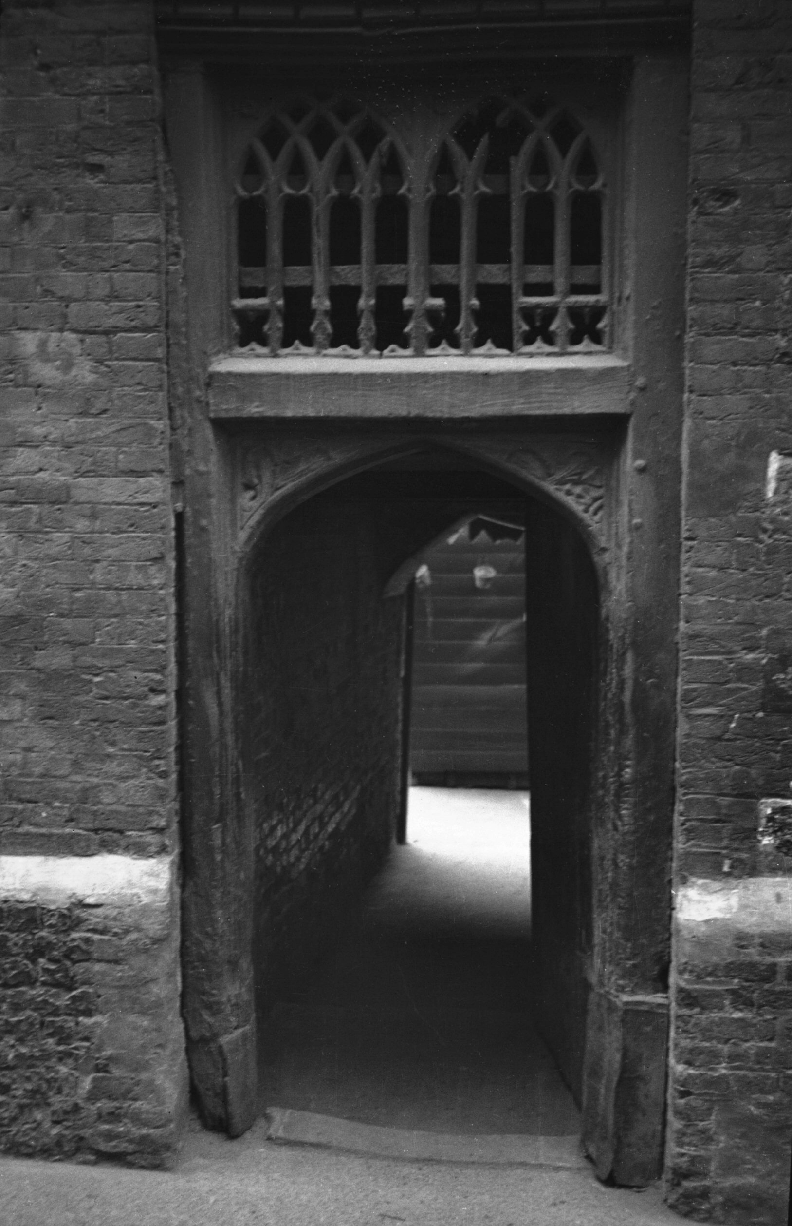
    The new main entrance to the Great Hospital.

    And this is the former entrance, which was on a blind corner and so not strategically useful in more modern times. The evidence of the old entrance drive isn’t hard to spot…….

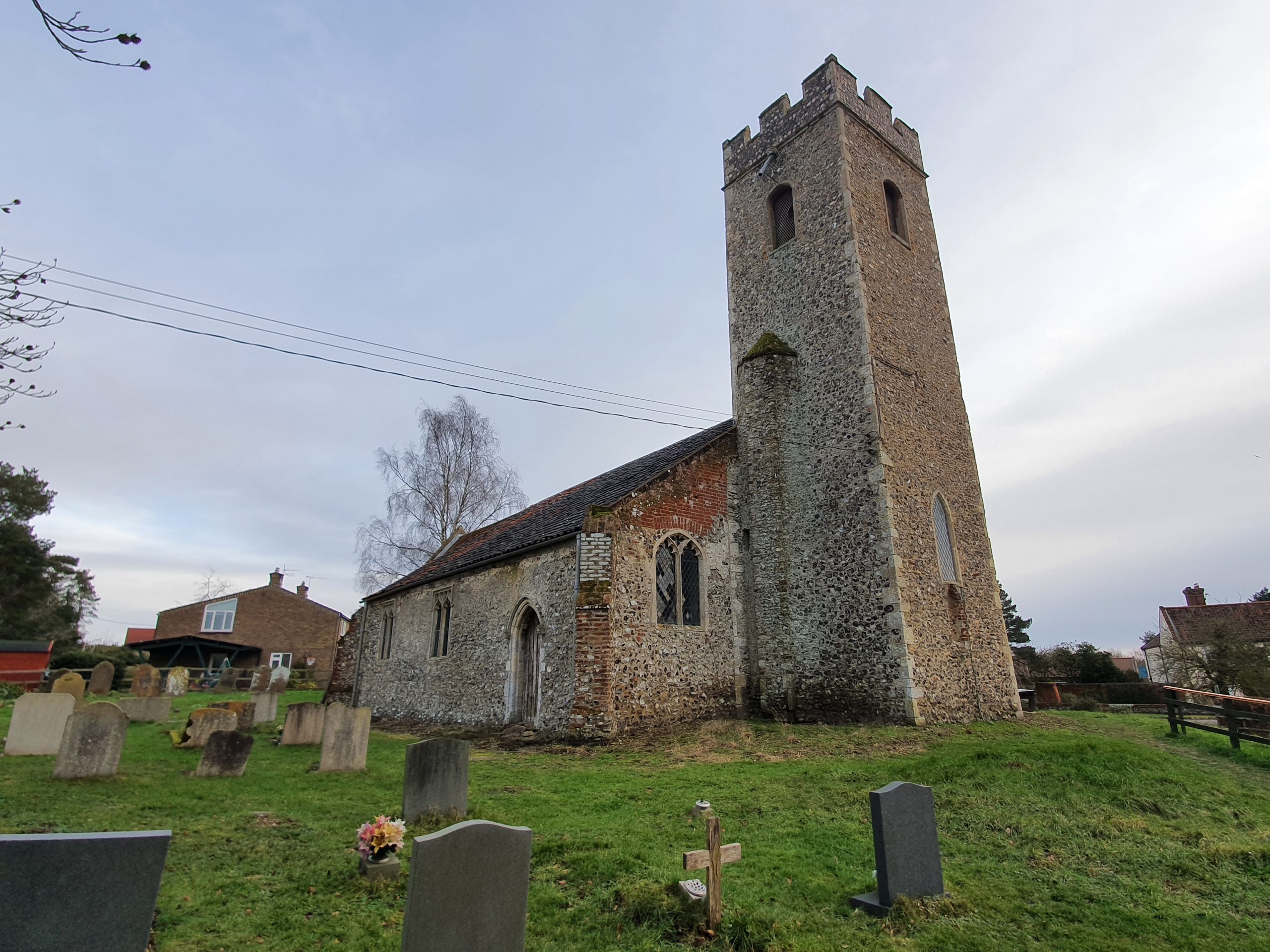
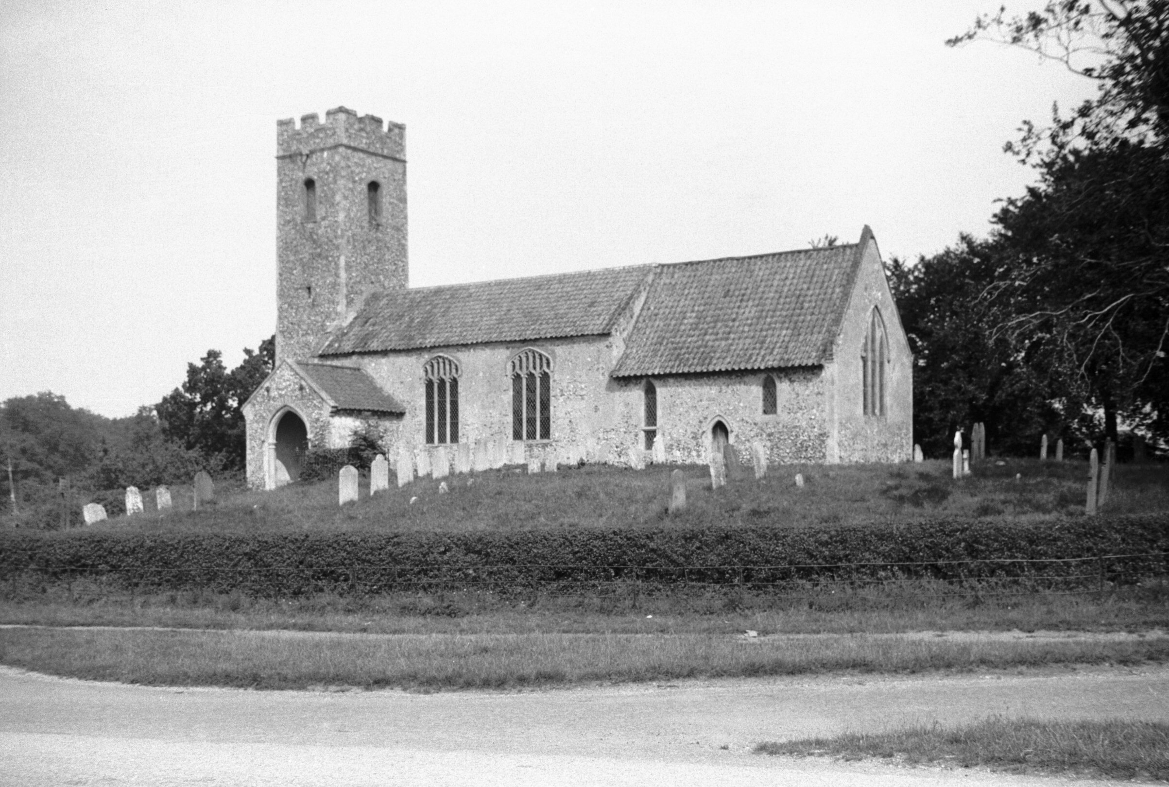
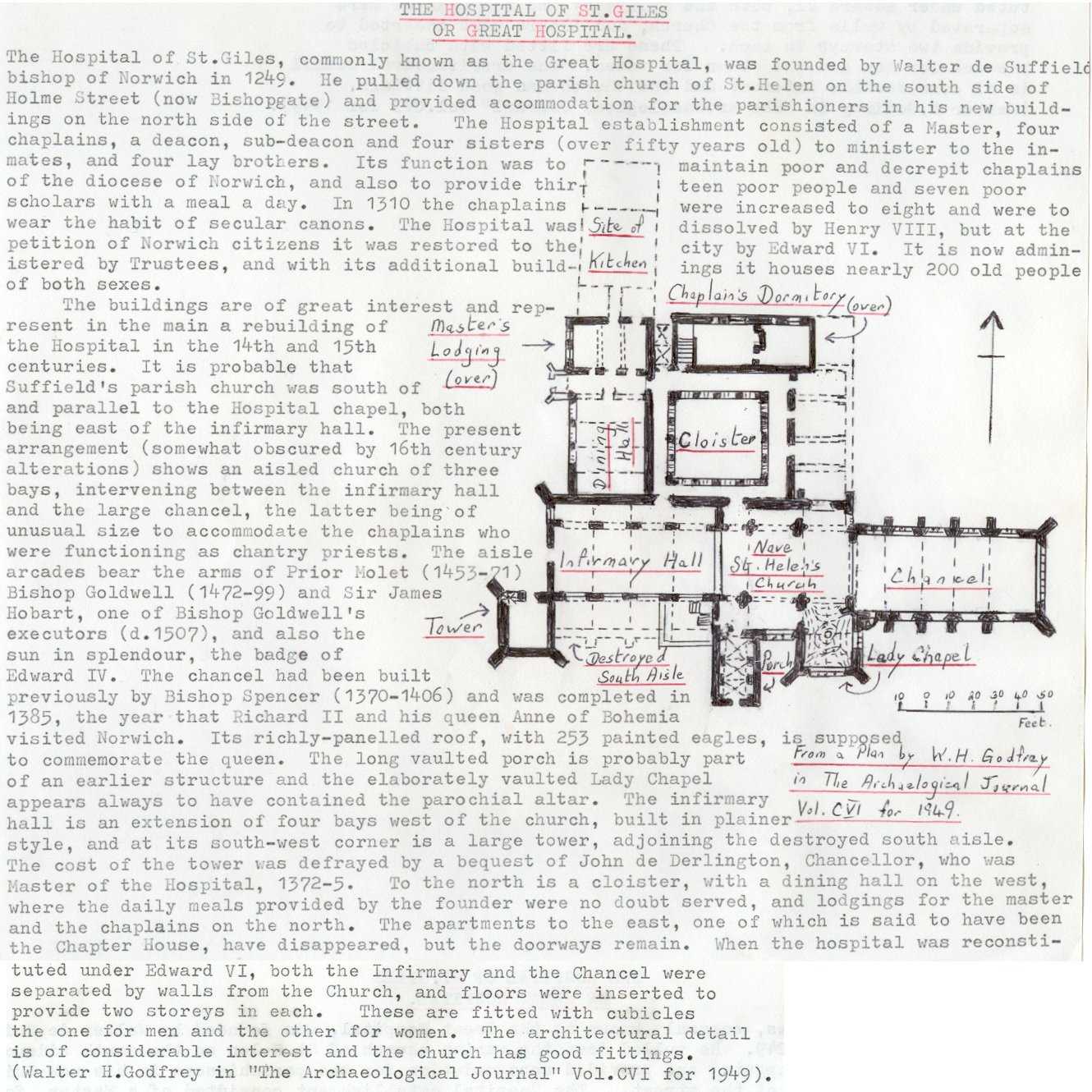
    This is the main part of the Great Hospital, with the former vicarage on the left and St. Helen’s Church on the right. George Plunkett (is there anything this remarkable man didn’t do for Norwich’s history?) has drawn a map of the complex.

    Going back a bit, this whole walk today was effectively on land owned by the Great Hospital, it was a powerful and wealthy institution. It had been founded in 1249 by Walter de Suffield and it helped retired priests and also local paupers. There’s a comprehensive history about the Great Hospital at http://www.thegreathospital.co.uk/, but one element is interesting and it’s the wait that the residents would have had at the Dissolution of the Monasteries to hear what would happen to them. They were lucky, not a great deal changed, just that the religious element of the institution became less important, but the charitable element remained.

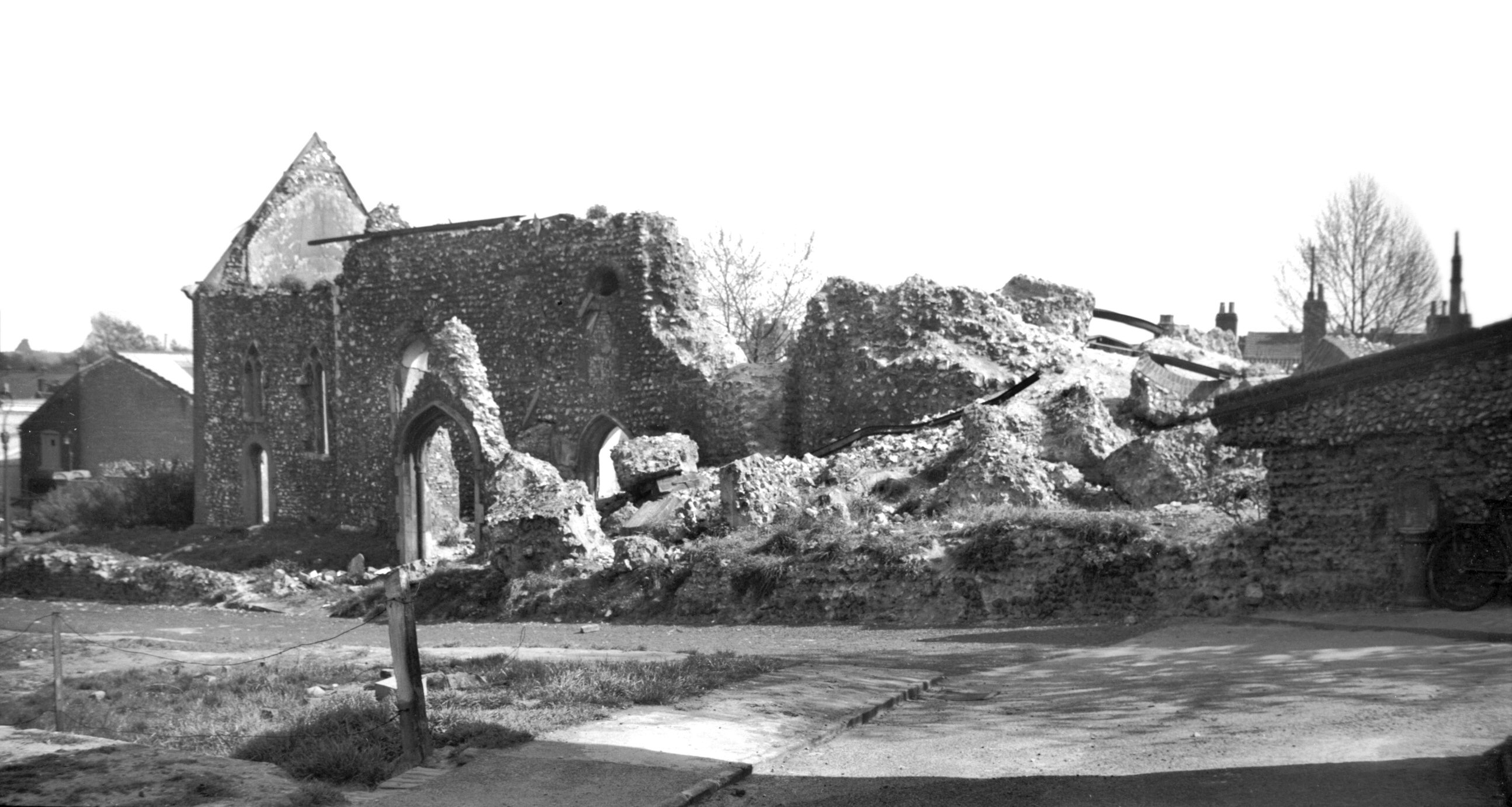
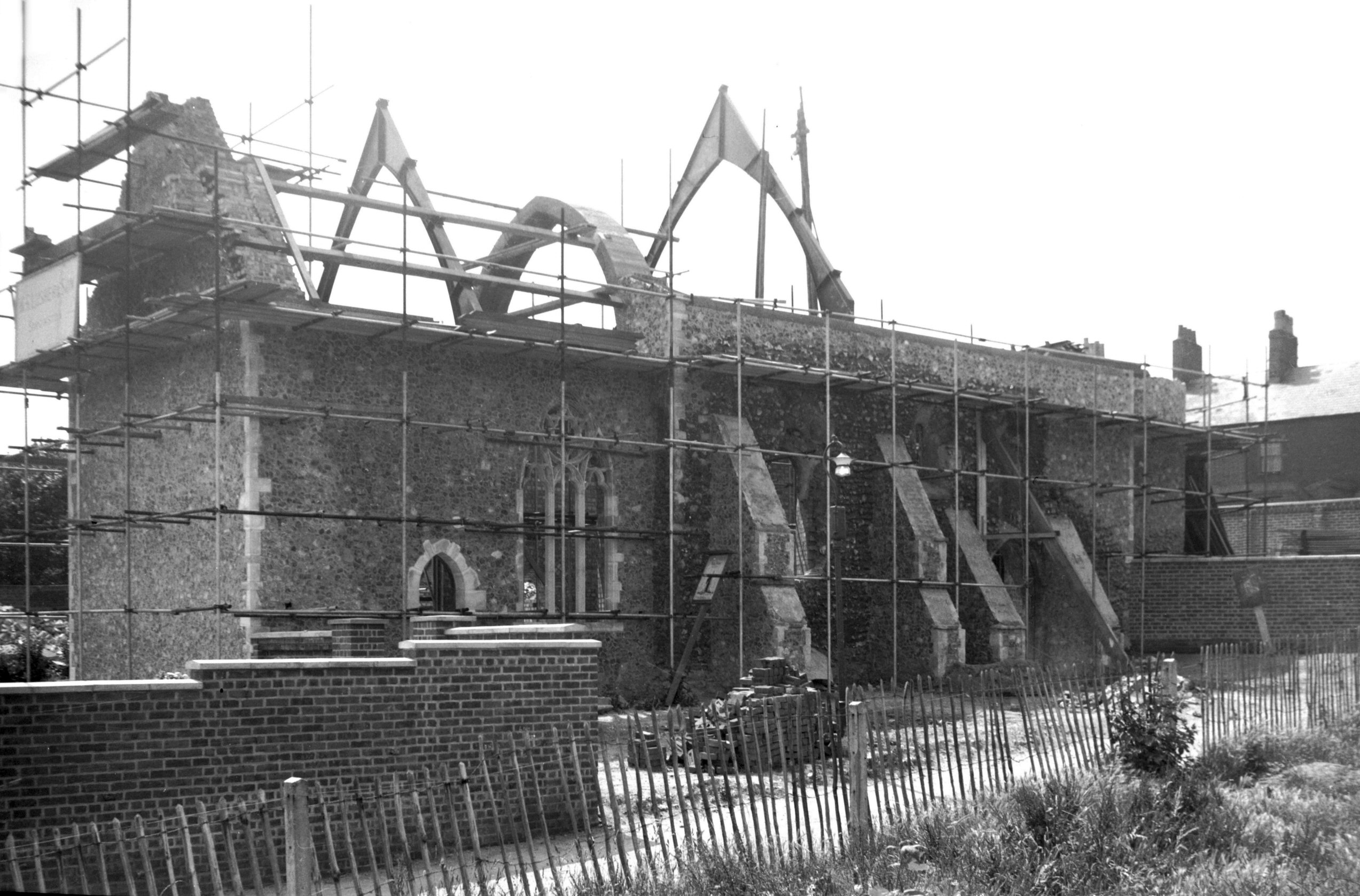
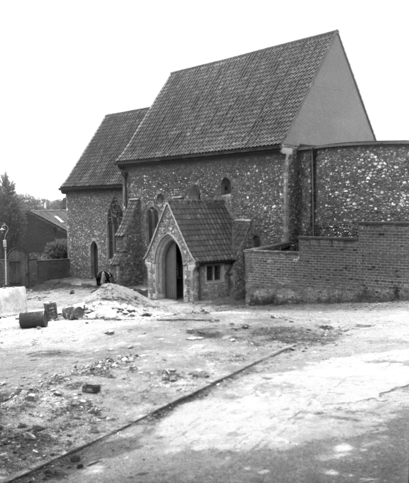
    St. Helen’s Church, a Grade I listed building of some considerable history, although this isn’t the first religious building on the site. When the Great Hospital was given the land and church in 1270, they decided to start planning a bigger structure, so the new and larger church was opened in the late fourteenth century and updated in the fifteenth century.

    The main part of the nave is still used for worship, and is one of the few churches in Norwich that I haven’t been able to visit yet. The chancel end was turned into accommodation that was only closed in the 1970s, but the photos at the Norfolk Churches web-site better tell the story.

    There’s a close-up of the text of that stone tablet at https://www.flickr.com/photos/norfolkodyssey/3788676616/.

    And the final picture for this parish. As mentioned earlier, ignore everything on the left hand side of the road, that’s in a different parish….. The right-hand side has changed enormously, with two pubs having been swept away, the Marquis of Granby and the Rose and Crown.

    So, this whole project is rather niche, although Jonathan and myself were rather engaged by this first attempt of ours. There’s an amazing amount of history which I’d managed to never notice before, although some has to be hunted for a little bit. Future parishes are larger, so will have more to challenge us…..