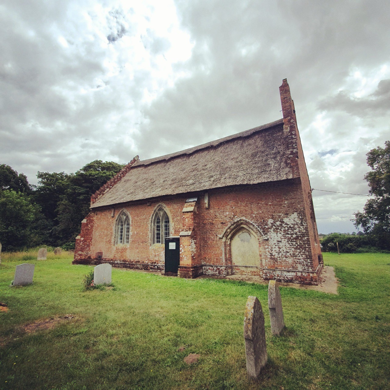
Category: Norfolk

  • Streets of Norwich – Drays Yard

    Streets of Norwich – Drays Yard

    Part of my Streets of Norwich project….

    I include this yard mostly for completeness than for any historical interest, as it’s a new yard with a limited amount of heritage. Located off of King Street, it’s located roughly in between the two PH symbols on the above map, on the King Street Old Brewery side of the map.

    As for why its called Drays Yard (the word dray is a beer delivery, or more precisely the cart the beer was carried on) I’m not sure, but I imagine it’s linked to the former nearby King Street Brewery site.

    There are mostly new residential plots in the yard.

  • Streets of Norwich – Scott’s Yard

    Streets of Norwich – Scott’s Yard

    Part of my Streets of Norwich project….

    Scott’s Yard is located off of Ber Street, connecting into Jolly Butchers Yard. It too once had a pub at its entrance, the Old Friends, which opened in the 1860s and was closed down in 1908 as part of the national plan to pay compensation to the owners of licensed properties (and it mostly went to the owners, not much went to the licencees themselves) in a bid to reduce the number of pubs.

    The yard was formerly primarily residential, but became more commercial during the late twentieth-century. This has since changed since planning permission was given in 2016 to demolish a warehouse and to build five residential dwellings.

  • Trowse – Name Origin

    Trowse – Name Origin

    Since a few of our walks have cut through Trowse, not least this one, here’s something about the origins of the village name.

    The Concise Oxford Dictionary comments on the origins:

    Trowse Newton, Norfolk. Treus Newtona in Domesday Book, Trous in 1254 and Trowes cum Newtone in 1316. Comes from Scandinavian tre-hus, or wooden house.

    The village is more formally known as Trowse with Newton and back in the tenth century, it was the case that Newton was the more important manner, and Trowse the attached settlement. There are some differing views about this, some people feel that it is ‘tree-house’ because the properties were once built in a wet area and needed to be raised.

    The argument on Wikipedia is that it’s named after a gate that could be lifted up and down, and they make some link to the word trousers. Personally, I think that sounds not inconsiderably fanciful. I’m with the settlement being named after the wooden houses that were located here in the tenth century, nothing to do with houses being built on stilts or with things being lifted up and down.

  • Pulham Market Railway Station For Sale

    Pulham Market Railway Station For Sale

    This would be a quite marvellous place to live, the former railway station of Pulham Market. Of course, it’d be even better if it had remained in use rather than being closed down to passengers in 1953, but at least it has been preserved. The 4-bedroom property is for sale with a suggested house price of £465,000, although it all looks spacious and there’s still a long platform at the rear. There’s also a bonus that the old red phone box and the signalling equipment put up by the platforms are all included in the sale.

    The property details are on the Rightmove web-site.

  • Lakenham – Name Origin

    Lakenham – Name Origin

    Following on from our walk which briefly went across Lakenham.

    The Concise Oxford Dictionary comments on this town name:

    Lakenham, Norfolk. Lakemham in Domesday Book, Lakeham in 1212, Lakenham 1247. Probably Laca’s Ham.

    So this is Laca’s village, a similar derivative to Lakenheath, which is the landing place of Laca’s people. It may be that Laca was just a local leader, but it’s probably more of a ‘tribe’ of fen-dwellers. With very little change to the place name over the last 1,000 years.

  • Eaton – Name Origin

    Eaton – Name Origin

    Following on from our training walk for the LDWA 100, Eaton is a common place name around the country. The Concise Oxford Dictionary comments on this name:

    Eaton, Norfolk. Ettuna in Domesday Book, Etona in 1147, Eton 1232.

    The dictionary does a job lot of explaining the word origin for all the places names in the country, as it’s a simple one, meaning ‘town on a river’.

  • Route of Ickneild Way Around Mulbarton and Swainsthorpe

    Route of Ickneild Way Around Mulbarton and Swainsthorpe

    I posted earlier about how the Norfolk and Norwich Archaeological Society have made back issues of their journal available on-line. And, there’s an article by JC Tingey that was published in 1900 which gives some ideas about the route of the Ickneild Way across Norfolk.

    The Ickneild Way is an ancient trackway that ran from Wiltshire to Norfolk and although some sections are still major footpaths, such as the Ridgeway, some stretches are lost. Tingey’s map of where he thought the trackway went in Norfolk is interesting, as we (Nathan and me, not Tingey and me…..) walked some of this route a couple of weeks ago.

    This is the route we took between Mulbarton and Caistor St Edmund.

    And this is the map proposed by Tingey, and we followed the left-hand section of the red line, leaving the route as it can be seen the path is no longer there. But, the author has a good point, there is a missing stretch of path that connects two other sections. It’s not something that I’ve thought about before, but it’s an interesting theory.

  • The Stone Bridge at Horse Fair

    The Stone Bridge at Horse Fair

    I posted earlier about how the Norfolk and Norwich Archaeological Society have made back issues of their journal available on-line. Meandering through a few issues, the Reverend W. Hudson wrote in 1884 about the stone bridge at Horse Fair. He noted:

    “Of the hundreds who in the course of a year make their way from Prince of Wales Road by St. Faith’s Lane into the Lower Close, probably nearly all could at once call to mind the old wall which skirts the road on their left; but scarcely one, perhaps, is aware that if he keeps close to the wall, at a point not far from where the wall bends round towards the open space called the Horse Fair, the ground is hollow under his feet, and he is in fact crossing over a bridge which once spanned a dyke which passed under the road”.

    Over 135 years later, that road layout hasn’t changed and I’m one of no doubt many who wasn’t aware of this bridge either.

    The full-sized map is visible by clicking on the above image, and I had no idea there was once a bridge here. Prince of Wales Road had just been laid out at that stage, hence why it’s pencilled in.

    The full article is available at https://archaeologydataservice.ac.uk/library/browse/details.xhtml?recordId=3236503.

  • Norfolk and Norwich Archaeological Society

    Norfolk and Norwich Archaeological Society

    This is a really useful thing to do, the Norfolk and Norwich Archaeological Society have scanned and made available all the back issues of their journal, Norfolk Archaeology. So, that’s 44 volumes and 1361 articles. Most useful.

    The link is at:

    http://www.nnas.info/NABackIssues.html

  • Shotesham – St. Martin’s Church

    Shotesham – St. Martin’s Church

    This ruined church is in Shotesham St. Mary and it’s dedicated to St. Martin, having originally been constructed in around the eleventh century. Most of the current building, or what’s left of it, dates to the fifteenth or sixteenth centuries.

    Looking towards the tower from the east end of the church. Walking with my friend Rob, he mentioned how clear the sky was without any aircraft trails visible, which is quite right but isn’t something that I’d thought about.

    The walls are made of flint, with some brick dressing, and are surprisingly robust in the sections that remain. They’ve received some work recently to strengthen them, so hopefully they’ll last for some time yet.

    The church was abandoned in probably the seventeenth century and it had become derelict by the nineteenth century. Given how many other churches there are in the Shotesham area, even the Victorians didn’t feel the need to restore this one.

    The former roof line where the nave met the tower is visible, but the high quality of the construction is apparent at the top of the arch.

    Until a few years ago, this church was covered in ivy which had taken hold from the 1950s and had made it more difficult to visit and it was also causing long-term damage to the structure. The work to clean up the site led to the discovery in the south wall of evidence of the location of the holy water stoup. There are no gravestones visible, but the site remains consecrated and it’s in the care of Shotesham Parochial Church Council.