Category: Streets of Norwich

  • Streets of Norwich – Stepping Lane

    Streets of Norwich – Stepping Lane

    Part of my Streets of Norwich project…. [updated in April 2024]

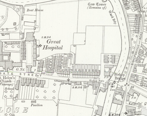
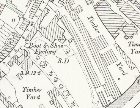
    There’s not much of Stepping Lane left that was here in this 1880s map and it’s now less than half of its previous length. A clumsy post-war rebuilding plan of the area meant that nearly all of the property here was demolished, Scoles Green is under a car park and Rouen Road ploughs right through the middle of the lane’s former route. I have no idea what the mention on the map of ‘site of Hendon’s City House’ is referring to.

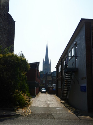
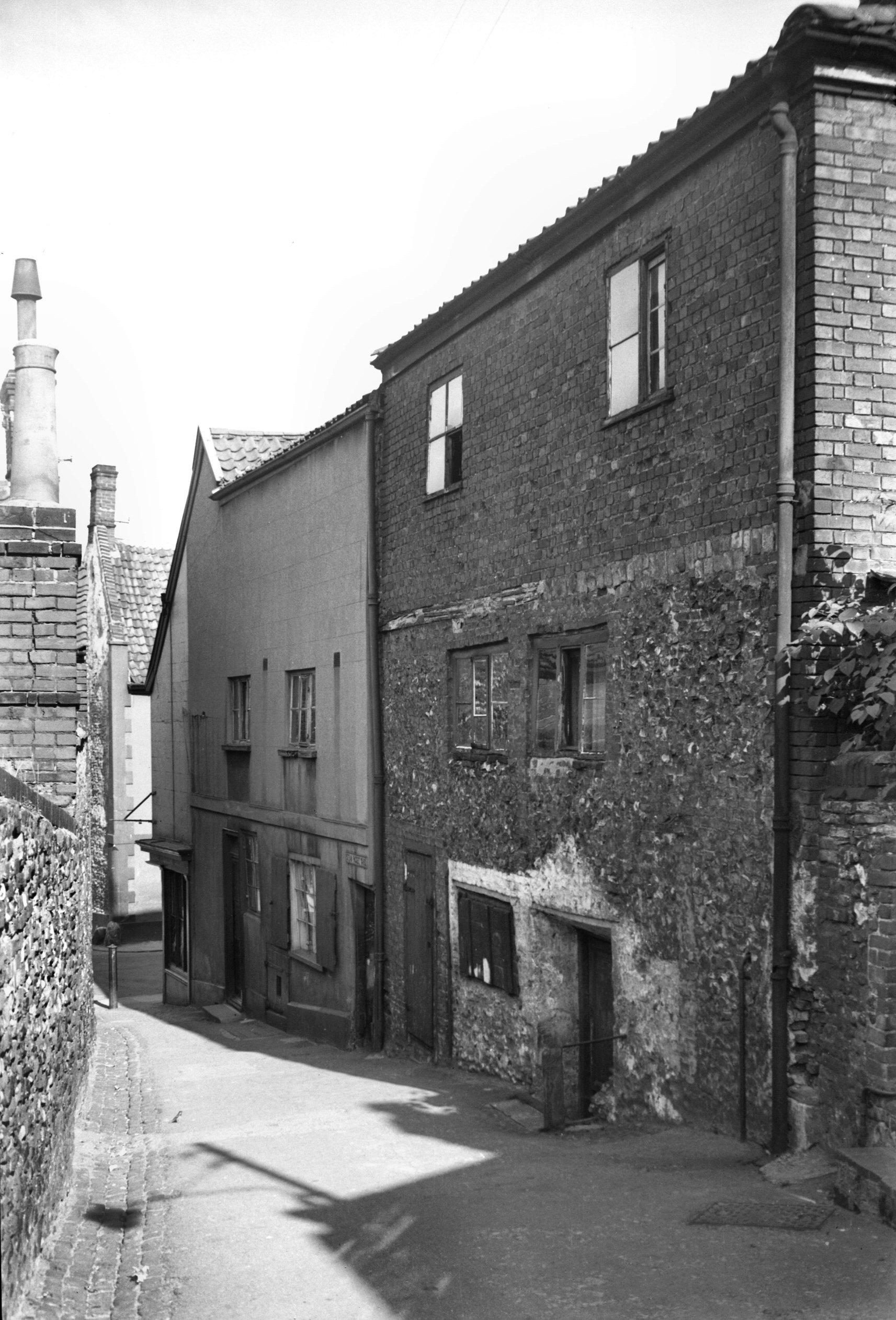
    The entrance to the lane from King Street, with the plot on the left-hand side once being the Steam Packet public house. George Plunkett, as usual, has a suitable photo here, taken looking back towards King Street. I like the quirky buildings which were once here, at least the older wall on one side has survived.

    In March 1873, it was reported in the Norwich Mercury that:

    “For auction, all those four cottages, in eight tenements, in Stepping Lane, with garden ground and use of yard, in the occupation of Robert Eagle, Widow North, Samuel Pyne, Widow Edwards, Widow Francis, Widow Southgate, Widow Sword and Widow Thompson, at rental amounting to £31 8s 4d per annum. This lot is leasehold from the Dean and Chapter of Norwich for a term of 40 years from the 7th December 1862.”

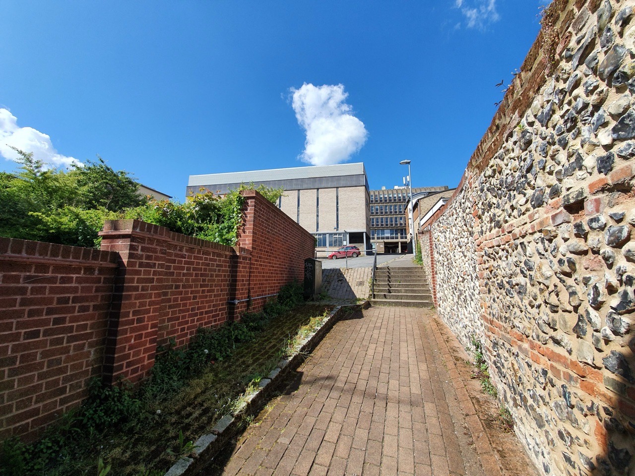
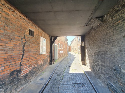
    And that’s about as far as the lane goes now, running into a lane called Normans Buildings, a throwback to when that was a street with residential properties on. It’s not exactly somewhere to make a special visit to if I’m being honest.

  • Streets of Norwich – Hansard Lane

    Streets of Norwich – Hansard Lane

    And another from my Streets of Norwich project….. [updated in January 2024]

    1260365

    This small lane off of Fishergate goes down to the River Wensum and it separates the Church of Saint Edmund from what is today an NHS building, but was once a large sawmill site.

    1260366

    There’s a rather nice view of Norwich Cathedral when looking down Hansard Lane. Before it was renamed in honour of local Norwich man Luke Hansard (of Parliamentary printing fame) in around 1890, this street was more simply known as Water Lane. Here’s an article about what was likely a murder near Water Lane that was reported in January 1824.

  • Streets of Norwich – Bishopgate and Norwich Lower School Gone By

    Streets of Norwich – Bishopgate and Norwich Lower School Gone By

    Screenshot-2020-05-15-at-12.08.12

    Linked to my Streets of Norwich – Goldsworths Buildings post…..

    John kindly got in touch regarding Norwich Lower School, which is a little further down Bishopgate. This is relevant as pupils had to walk by the former Goldsworths Buildings to get to the football pitch near to the river.

    There will be a longer interview in the new year on this, but John mentioned:

    “The Lower School was built in the old fashioned style common to state schools in the late 19th and early 20th centuries, with high windows and a pitched roof. Think of it as an elongated rectangle divided laterally into three classrooms. The room nearest Bishopgate was the 2 J classroom (Mr Christopher Smith, known by us as Smithy), then Form 2 (Mrs Edith Stephenson, the headmaster’s stepmother, who we referred to as Ma Stevo) and furthest back was Form 1 (Mrs Spruce, known irreverently as Fanny – we had no concept of the more slangy meaning of this word as it is often used nowadays, it was just a female name as used by Jane Austen for Fanny Price). We were turned out at break times on to the School Field. The loos were also outside and froze up in the cold spells which happened every winter in those days, accompanied by snow and ice. The whole setup would have failed a modern school buildings inspection and the place was demolished after the next Lower School was built in (I think) the mid 1960s.”

    I hadn’t known much about the old Lower School, which was replaced in either the late 1970s or early 1980s with the current building. There was an arson attack in something like 1989 which caused significant damage, but the general structure of the building was restored, although extended.

    Unfortunately, the late and great George Plunkett doesn’t have any photos of the school in its current or former incarnation, so I’ll go on the hunt elsewhere for those.

  • Streets of Norwich – Albert Place

    Streets of Norwich – Albert Place

    20200504_113248

    Part of my Streets of Norwich project…. [Updated in November 2023]

    Albert Place is a small road located off of Telegraph Lane West, which is visible on the above map coming off of Albert Road, but the top section is no longer there and is underneath some more modern housing.

    20200504_113242

    This is all that is left now, so there’s not much that I can write here.

    But, there is a story about two former residents of this street, Mr. W. Scott and his wife, who both incurred head injuries from a major railway accident which took place on 10 September 1874. An express train running from London to Great Yarmouth hit a mail train from Great Yarmouth to Norwich at some speed near Thorpe Junction, given some communication confusion caused by a telegraph clerk. 25 people were killed, including both sets of drivers and firemen, with a further 75 being injured. The disaster led to the introduction Tyer’s Electric Train Tablet, a token based system which made it impossible for two trains to be on the same section of track.

    And, as another story, John Abel advertised in the Norwich Mercury on 7 September 1896 the below:

    “This is to give notice, that on and after this date I will not be responsible for any debts contracted by my wife, Charlotte Abel.

    John Abel, Albert Place, Albert Road, St. Leonard’s Road, Norwich.”

    I’m not entirely sure what happened there….

  • Streets of Norwich – One Post Alley

    Streets of Norwich – One Post Alley

    Part of my Streets of Norwich project…. [updated in October 2023]

    20210105_121836

    I’ve never noticed this alley before, it’s only through following a history trail produced by Norwich City Council (and more on these three trails later) that I came down here.

    Screenshot-2021-01-05-at-19.24.38

    The alley connected St. Stephen’s with St. Stephen’s Back Street, although that latter street has gone and is now the boundary of Chapelfield (or Chantry as it’s now called) shopping centre.

    20210105_121832

    It’s quite hard to make out this alley in old maps as it’s so narrow, but it appears to have been the one known as Stockings Alley, I assume after the nearby butcher. At the end of the alley (so on the left of the above photo) was the Unicorn Inn public house, sadly now demolished.

    20210105_121934

    It’s not the most decadent of alleys if I’m being honest and there’s a limited amount of history that I can find to recount about it. However, according to the city council’s history, it takes its current name from there being one single post blocking the end of the alley off. And it was being blocked off to stop any cows disappearing up it when they were being taken to Norwich cattle market, although I had thought the cattle usually came from the direction of Norwich railway station and Prince of Wales Road. Either way, I like that this path has survived, it reminds me of the rows in Great Yarmouth and I’m pleased it hasn’t been incorporated into some shop in the way that a number of other yards on this road have been.

    In September 1890, there was a newspaper article featuring the case of Elizabeth Houghton, a widow who lived along the alley. Detective Barlow, a police officer, noted that Houghton had been lifting up wood blocks that were being used to pave Prince of Wales Road. She hid these wooden blocks under her long cloak and so he decided, rather sensibly, to question Houghton on what she was doing. She wasn’t too keen on assisting the police with their enquiries, but he followed her back to One Post Alley. He then had a little rummage around and found that she had a heap of these blocks which she then admitted that she was using for firewood. It seems sub-optimal that she was burning the council’s new road surfaces, but I can imagine times must have been tough given she had lost her husband. The police were less forgiving as they claimed the amount of wood was substantial and the City Corporation said they had lost 1s 5d worth of blocks. The matter was so serious that it got sent to the next Quarter Sessions.

  • Streets of Norwich – Baltic Wharf

    Streets of Norwich – Baltic Wharf

    Part of my Streets of Norwich project…. This post was updated in October 2023.

    Screenshot-2020-05-13-at-13.11.16

    Baltic Wharf is a relatively new road, it follows the line of the trees on this map from around 1900. SD on maps from this period either means sun-dial or a single-drain, so that little tiny circle next to the S might be a sun-dial…. There was a Baltic Wharf in the nineteenth century, but that was located a little further down the river.

    20200512_102725

    There’s not a great deal of historic interest on Baltic Wharf, which leads off Mountergate, with the exception of St. Faith’s House which is a listed building. It was built as a three-storey grand private residence in the eighteenth century, although it’s now used as offices.

    There was a planning application put in on November 2018 to build seventeen dwellings around the building and to change the property itself by kicking the businesses out and putting five flats in. The road is next to the large St. Anne’s Quarter residential building development (I thought the word quarter was being phased out, it has been so over-used recently….) and so this was always likely inevitable.

  • Streets of Norwich – Goldsworths Buildings

    Streets of Norwich – Goldsworths Buildings

    Part of my Streets of Norwich project…. (updated in October 2023)

    20200515_110919

    I’m not entirely sure that there’s much of a street here, but there is a road name visible, so that’ll do for me.

    Screenshot-2020-05-15-at-12.08.12

    That road name visible in the previous photo is located on the Red Lion pub, but I wonder if it originally more described that row of buildings above the pub on this map from 1900. These buildings have since been demolished and the site is now used as the pub’s car park.

    20200515_110916

    Here’s the Red Lion, currently boarded up, although it was closed before the Covid-19 situation.

    20200515_110914

    This road seems to me to still be Bishopgate on maps, so it seems that the modern-day Goldsworths Buildings road is really now just the Red Lion pub and its car park. The landlord of the pub between 1842 and 1845 was James Goldsworth jr, so I have this idea that he built the properties by the pub and named them after himself. I have no evidence of this, but it makes for a nice story, so I’m going with it.

  • Streets of Norwich – Fishergate

    Streets of Norwich – Fishergate

    Part of my Streets of Norwich project…. [updated in October 2023]

    1260360

    Fishergate is one of the streets in Norwich which has retained its street line and its name over the last few centuries, connecting Whitefriars to Fye Bridge Street.

    1260362

    The Church of St. Edmund, a fifteenth century building which was modernised (and, just a little bit ruined in my view) in the Victorian period, although it was built on the site of an earlier church which was likely Saxon. The number of residential properties in the area fell during the later part of the nineteenth century and the church fell into disuse during the early twentieth century. It was later used as a store for Norwich Puppet Theatre, although it now appears to be back in use as a religious building.

    1260370

    One of the Viking Norwich signs, of which there are several in this area. The street has been known as both Fishgate and Fishergate, both with the same original meaning of ‘street of the fishermen’.

    1260367

    The building painted light blue in the above photo is interesting, it’s the former Duke of Marlborough pub. It was closed in 1969 having been a licensed premises since at least the beginning of the eighteenth century.

    To the right of the Duke of Marlborough was the Rampant Horse pub, long since demolished. This was a casualty of the removal of licenses from properties at the beginning of the twentieth century, an act which closed thousands of pubs throughout the country. To the left of the Duke of Marlborough, now no longer accessible, was Thoroughfare Yard, although this is still accessible from another entrance point.

    On the matter of pubs, there was once a Carpenters Arms located on Fishergate but the records suggest it was only there in the 1830s and it’s not clear exactly where it was. There was also the Golden Fleece which was a licensed premises between sometime in the 1830s and 1867.

    1260369

    Formerly the offices of J Bugg Ltd, boot and leather manufacturers.

    1260368

    This section at the end of Fishergate, where it meets Fye Bridge Street, has been turned into a small park. I’m not sure why nothing is now here, although some buildings on this section were badly damaged during the Second World War. This little park is on the right hand side of this 1933 photo from George Plunkett.

  • Streets of Norwich – Swan Lane

    Streets of Norwich – Swan Lane

    Part of my Streets of Norwich project…. [updated in October 2023]

    20200420_091528

    Swan Lane is located in central Norwich and was originally called Rakeytheslane, or Rackey Lane, as Robert de Rakheythe had a house along the street. It changed its name in the nineteenth century because this was the location of the Swan Tavern, and I think it’s a rather lovely idea to name streets after pubs.

    20200420_091539

    Fortunately, given its width, this is a pedestrianised street. At one end is London Street, which was the first street to be pedestrianised in the country, but motor vehicles had already long since been banned from going down Swan Lane.

    Screenshot-2020-04-20-at-14.00.14

    The city in 1830, and not much has changed with the street layout of Swan Lane in the last two hundred years. The Swan pub was at number 8 from around 1750 until the early 1860s, although there are no pubs at all along the street by 1870. And that, in Norwich, is a fairly rare state of affairs….

    20200420_091556-1

    This sign about Jem Mace is on the side of Turtle Bay.

    20200420_091618

    Changing street numbers can be a curse to trying to understand building history, but this might fit in, as in around 1870 the property at number 8 had been rebuilt. The new structure was a grand building, with 4 bays facing onto Bedford Street and 5 bays onto Swan Lane. This was used as a shop until only a few years ago, when it was converted from being the Fabric Warehouse into the Turtle Bay restaurant, which is the building on the right in the above photo.

    20200420_091520

    The entrance to Swan Lane from London Street, with something I missed (hence why it’s not very clear in the photo either), which is the entrance to a courtyard at 2 Swan Lane, on the far left of the Dipples building. I only noticed it from the listed building record, as Dipples is a Grade II listed property, originally constructed in the early nineteenth century and the frontage of the shop is original (apparently not the right-hand side window).

    20200420_091531

    The swan in the front of Dipple and Son. The history of this company is interesting in itself, their web-site mentions:

    “Dipples itself is nearly 140 years old. The jewellery business was originally founded in 1878 in Woodford, Essex, by George Henry Dipple. George did not stay in Woodford for very long as by 1890 he is no longer registered as living in Woodford. Between 1888 and 1890 the business was relocated to Ipswich. The jewellery store made a final move to Norwich around 1894 and has been located in Swan Lane every since.”

  • Streets of Norwich – Jolly Butchers Yard

    Streets of Norwich – Jolly Butchers Yard

    Part of my Streets of Norwich project…. [updated in September 2023]

    Screenshot-2020-06-02-at-21.43.28

    Jolly Butchers Yard is located off of Oak Street and is named after the pub which stands to the left of the yard and which traded until 1989 when it was converted into offices the following year.

    20200601_135322

    The yard is still there and there are residential properties within it, so this is one of the yards which retains some of its former character. It’s a shame that the pub is no longer trading as it had been a licensed premises since the beginning of the nineteenth century and was clearly packed with intrigue and adventure.

    20200601_135331

    There’s a plaque which notes that Black Anna (her real name was Antoinette Hannent), the jazz and blues singer, lived here between 1935 and 1976 and she got the name as she only wore black clothing. She said about this habit (please note the clever wordplay there given what she said….), “I’ve had people ask what order I belong to, a bad one I tell them” and the below video clip features her saying this. The video was filmed in the Jolly Butchers in what was probably the early 1970s and it’s entirely evident what an amazing and inspirational landlady she must have been.

    There was a news story published in the Yarmouth Independent in May 1936 which had the title “GREAT BIG ROW” which sounds very Archant…… It noted that Walter Douglas from 7 Jolly Butchers Yard had an argument with his wife Gertrude Douglas and they used foul language within the yard during this big row. Elizabeth Carrara was watching the dispute from her window on the rear of Ber Street and it was actually her who made a statement about the “great big row” as she called it. I rather fear that this was a matter of domestic abuse, but the court decided to fine them each five shillings for their abusive language.