
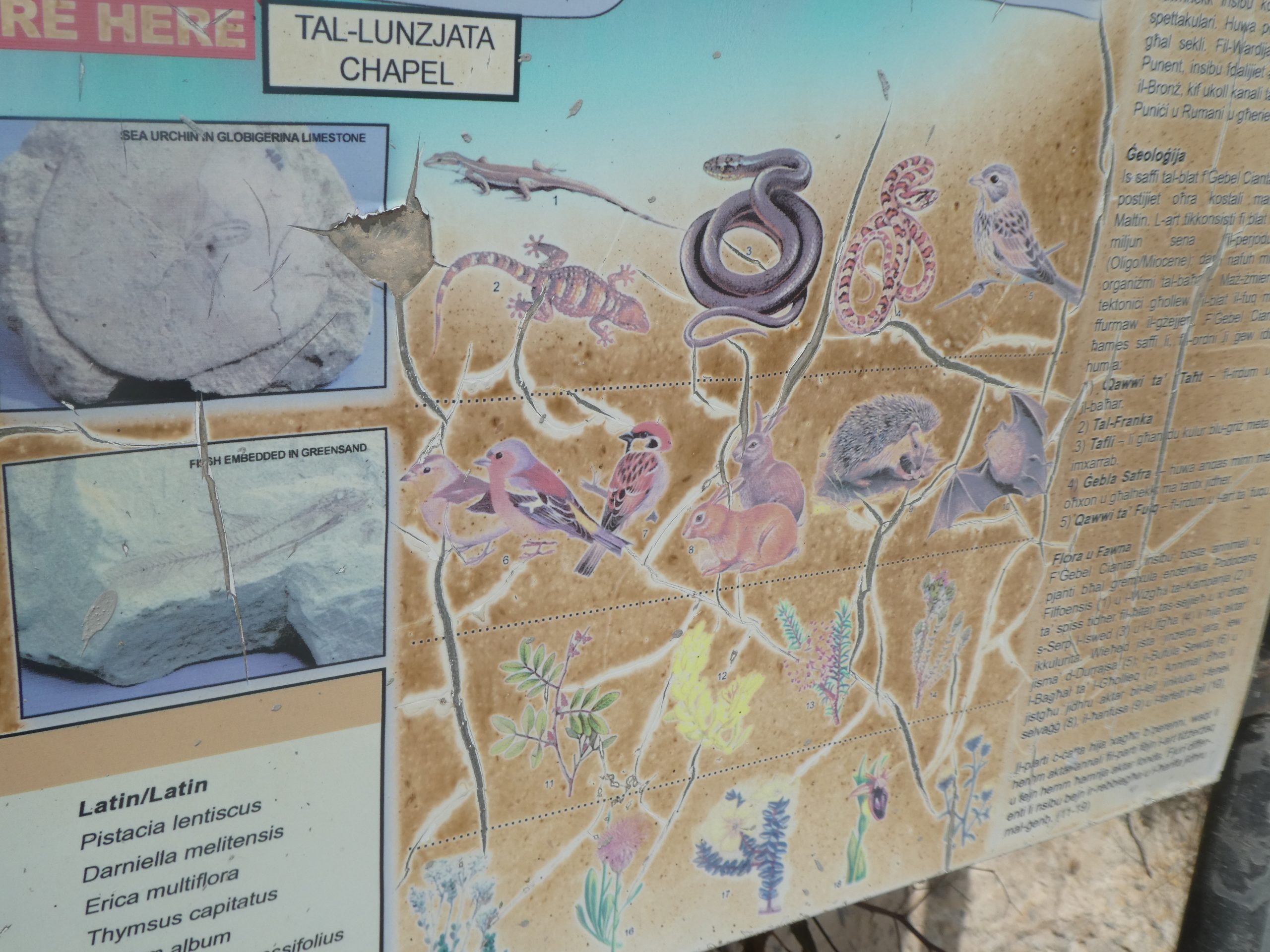
I wasn’t entirely thrilled to see this. Apparently there are black Western Whip snakes and Leopard snakes roaming around free and unhindered in the area….. I checked and the Leopard snake doesn’t eat prey the size of a leopard, it just has similar colouring and is also known as a ratsnake. The black Western Whip snakes can grow to as long as two metres in length, and although I’m sure it’s a very lovely animal, I don’t want to meet one in the wild. Fortunately, we didn’t see any snakes whilst in Malta, but I tried to walk quite heavily to scare any off that might be nearby.
Category: Malta (Southern Region)
-
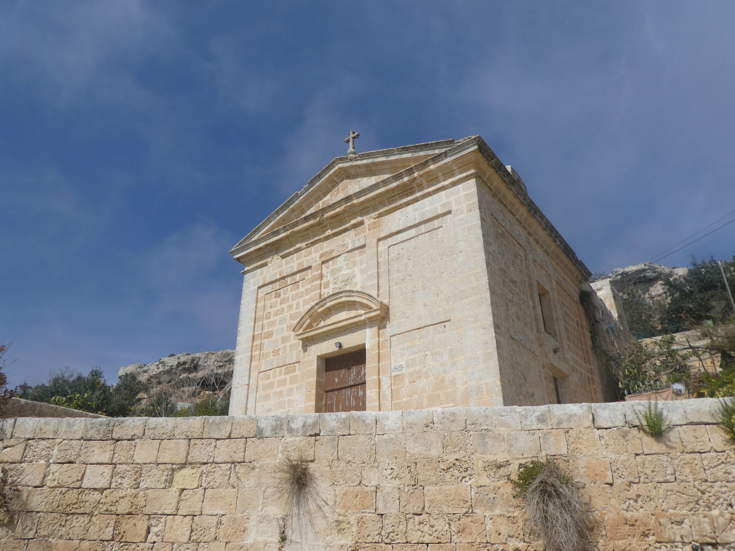
Malta – Southern Region – Fawwara Church of the Annunciation
There has been a church on this site since the early seventeenth century, although the current building primarily dates to the early eighteenth century. The earlier church had become a bit dilapidated and mostly fallen down, so it wouldn’t have been a difficult decision to make. The construction was funded by the Xiberras family and was constructed to a better design standard than the original structures, being dedicated in 1708.
The church wasn’t open when we walked by, although it remains in religious use. It was originally dedicated to the Assumption of Our Lady, although this was changed to the Annunciation of the Virgin Mary when it was reconstructed.
-
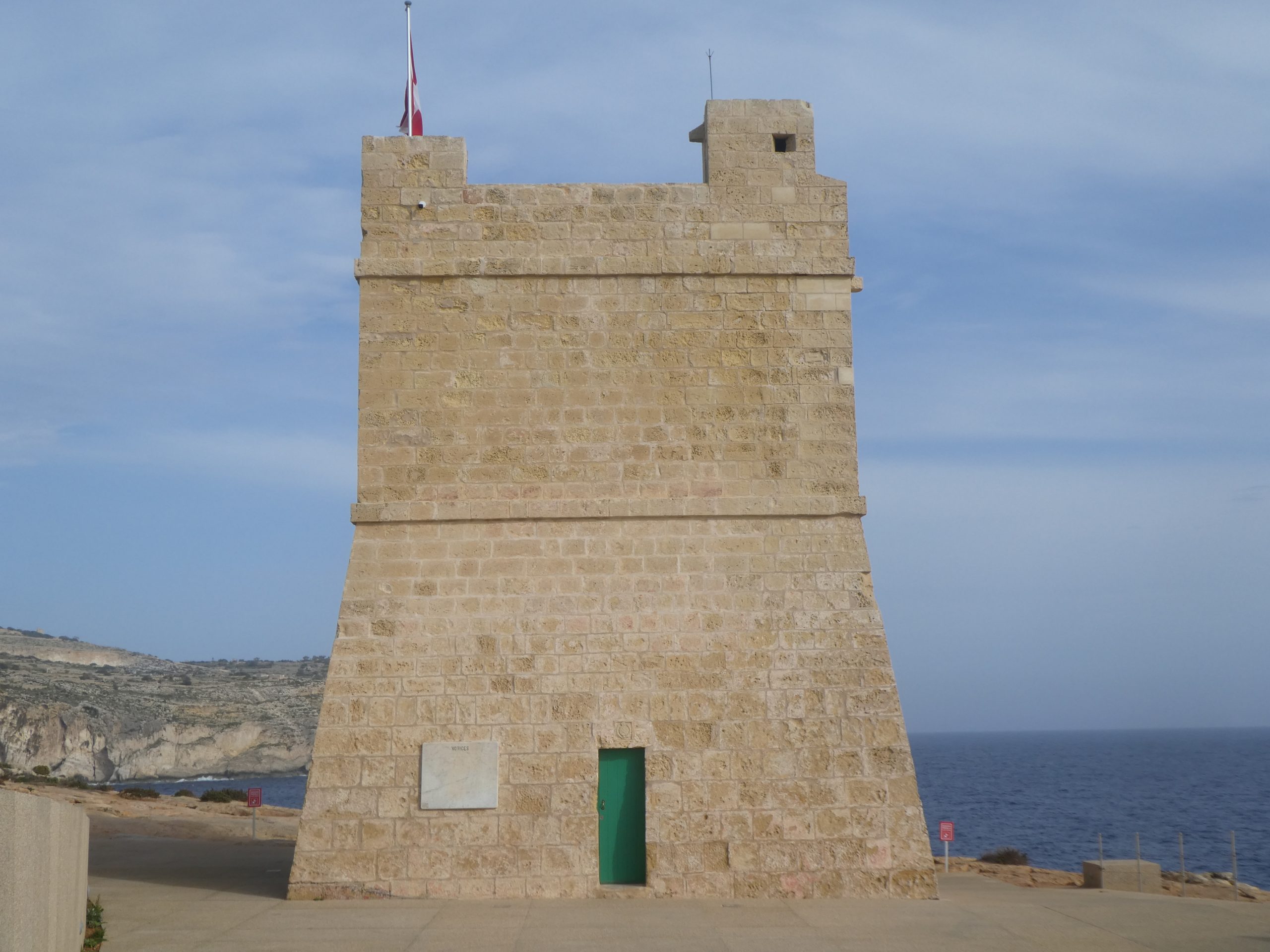
Malta – Southern Region – Sciuta Tower
This is one of the ten Lascaris Towers which were built 1637 and 1652, with nine of the towers still standing today. Sciuta Tower is located near to the Blue Grotto, making it one of the most visible of the towers given the number of passing visitors. This particular tower was built in 1638 and one of the De Redin Towers was later built relatively nearby to this one. It was used until the Knights of St. John were forced to leave Malta, with the British using it until 1873 when it then fell out of use as a military defence post other than for a brief period during the Second World War. It has since been used as a police station and storage tower, but has recently been renovated and restored.

The tower can now be accessed by the public, but it was closed when we walked by. It’s one of the last sights to see on the heritage walk which starts at Dingli Cliffs and anyone walking by it along the coast will see some excellent views of the Blue Grotto.
-
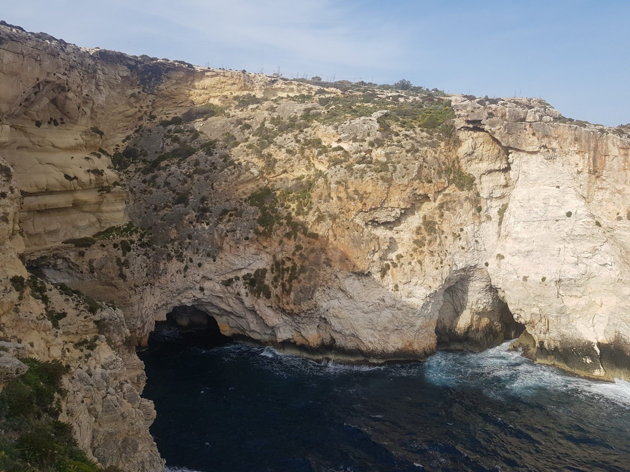
Malta – Southern Region – Blue Grotto
The Blue Grotto was at the end of our walk along the southern part of Malta, starting from the Dingli Cliffs. Taking its name from the bright blue water, something achieved by the sun and local flora, these caves are a popular destination. We didn’t have time to take a little boat ride around the caves, although I’d investigate that possibility on future visits, to get nearer to them.
The caves have been featured in numerous television and film productions, as well as being the backdrop for one of the Cadbury’s Milk Tray ads. I can’t find any mention to the Blue Grotto in the nineteenth century, with all the references being post-war, but the site has long since been a popular tourist attraction. There are some cafes and bars on site, as well as regular buses with run to Rabat and Valletta. It has all perhaps become a bit over-popular, but it’s still an impressive sight and there weren’t too many crowds during March at least.


-
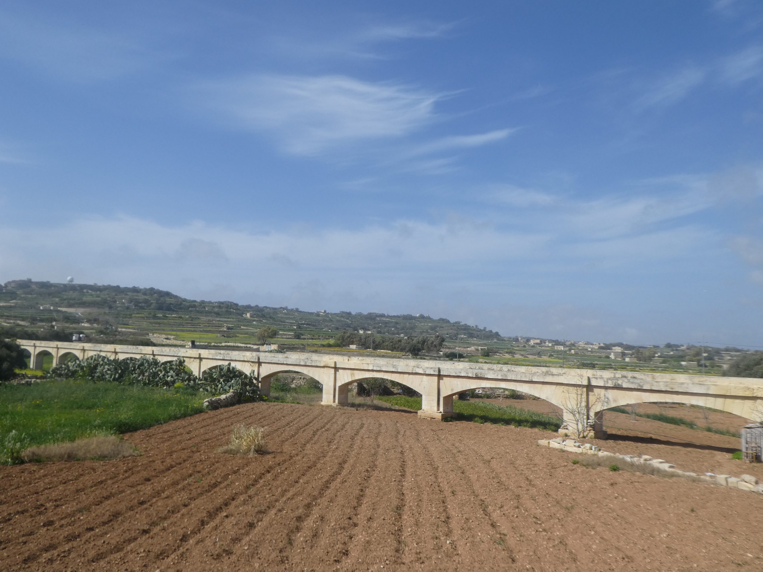
Malta – Southern Region – Fawwara Aqueduct
The Fawwara Aqueduct was the country’s second and was designed to transport water between Fawwara and locations such as Luqa, Tarxien, the Three Cities and Zabbar. It was commissioned during the period of Henry Bouverie’s governorship of Malta, a military man who held the role between 1836 and 1843. The aqueduct came into use in 1845 to try and allow water to reach as much of the island as possible.

The aqueduct could transport over 80,000 gallons of water every hour.

The aqueduct and Liam, with the route of the original stone structure being difficult to follow on an overhead map as much of it seems to have been destroyed without trace.
-
Malta – Southern Region – Birżebbuġa – Għar Dalam

Located just to the north of Birżebbuġa is this prehistoric cave which is where the first evidence of human life on Malta is recorded, dating back nearly 7,500 years.

The skeleton of a brown bear, one of the many animals which died in the cave.

Part of the museum collection of the bones and other remains which were found at the site. There is a real focus on quantity, which isn’t unusual for the time, rather than displaying the most important pieces, but it looks quite impressive when entering the room.

The museum has rather started to heap things up now, although I doubt that these displays have changed much in many years. I quite like the heritage of the displays in many ways, although the museum does perhaps need a little bit of an update.

When they excavated the caves they found a series of different layers of bones and detritus, this is the deer bone layer dating to the period of 13,000 to 18,000 years ago.

After the museum visit is the walk down to the cave, which I managed to time beautifully between two school groups. It’s very lovely that school groups come to look at historic sites, but I prefer them to do it just before I arrive and just after I leave.

Views of the countryside whilst walking down to the caves.

The entrance to the caves, fenced off to prevent vandalism which has unfortunately been a problem at this site in the past.

An example of the different layers which were found at the site.

The walkway, looking back towards the entrance.

Views inside the cave.

Visitors are limited as to how far they can go in case they stand on a woodlouse.

This is the hippopotamus layer and these were on the islands until around 10,000 years ago. There’s also evidence of dwarf elephants which are when larger animals become smaller when in a confined area, such as Malta, because there wouldn’t otherwise be enough food available for them.
Overall, a fascinating site, although more information panels at the site might have been useful to ascertain exactly what some features were. I had my Heritage Malta pass, but the entrance was only a few euros, worth it to imagine humans occupying these caves so many thousands of years ago.
-
Malta – Southern Region – Mnajdra Temples

Located near to the Ħaġar Qim Temples, these temples are of a similar date although are made from a different type of stone. The site was first investigated at the same time and there are many other commonalities between them.
I had my ticket ready to enter the temples, although the man in the shed checking tickets smiled and waved me through without checking. He seemed to be checking the tickets of other people, so I must have just looked very trusting. Anyway, I had a ticket, so all was well and I could remain guilt free.

They selected a nice spot for their temple, extensive sea views. As may be evident from the photo, it was about to pour with rain during my visit, so the shelter was appreciated.

Interestingly, and shockingly, much of this site is repaired after a serious vandalism attack in April 2001 when 60 of the stones were toppled over. Some clever restoration took place to correct the damage, which must have been heart-breaking for the museum authorities. The police apparently knew which three people did it, but had insufficient evidence to prosecute.

One of the apses in the temple.

Looking out towards the edge of the site. Unfortunately I’m not enough of a temple expert to really understand this site, but there was an upper and lower section, with the upper section having been constructed first. It’s not known why the temples were built, but it’s thought to have had a religious or fertility related significance.

Some of the more eroded stones. As with other temples, they have a relevance to the solstices, when light would have shone through. Whether this was for religious or more practical farming reasons isn’t known, but what a clever piece of engineering to be able to make that work. The protective shelter over the top of the site was only added in 2009, perhaps a little too late to prevent the damage from the elements.
These temples are part of a heritage walk along the coast, which I walked some of, but the rain was too hard to complete it. I might have persisted but it started thundering and lightning, and I didn’t want to be standing on a high cliff edge with that going on….
-
Malta – Southern Region – Congreve Memorial

This is the Congreve Memorial which commemorates the life of Walter Norris Congreve, a well respected English army officer who later became the Governor of Malta between 1924 and 1927. Congreve was also awarded the substantial honour of the Victoria Cross.

Congreve was buried between the main island of Malta and the small island (or big rock) of Filfla.

Congreve’s memorial procession in Valletta in 1927.

Photos of the burial at sea which were published in the Illustrated London News.
-
Malta – Southern Region – Ħaġar Qim Temples

Ħaġar Qim Temples date to around 3,500BC and are another in the series of neolithic temples across Malta which still hold many mysteries. They were mostly buried naturally over time, although some stones remained visible, until an archaeological dig which took place in 1839. Inevitably, given the age, this has now become a UNESCO World Heritage Site.
This site is linked to another nearby historic site, the Mnajdra Temples, and they share a museum which I’ll post about separately. The museum is something a little different and some thought has been put into creating an environment which is relevant for visitors of all ages.

The entrance into the site. Unfortunately I went around the site in the wrong order and so I didn’t get an audio guide, which meant that I didn’t have a clue what I was looking at for much of the time. I didn’t get a map either as are offered at most other Heritage Malta sites. But, if I had gone the correct way round, I would have had these….

One of the porthole doorways, all made from one large piece of stone. It is known that these temples weren’t used for burials of humans, although animal bone sacrifices have been found, and it’s also known that circular stones were used to transport the larger stones around.

In the museum there is a photograph showing how well preserved these stones were in the nineteenth century, and how they deteriorated after they had been exposed. Unfortunately that means that these have been restored, which does limit my enthusiasm just a little. Nearly all of the site is though original, it’s just that some clumsy restoration work in the early twentieth century made things a little worse than need be when cement was used….

The obese figures, although not much of them remain. Although I might not really understand these sites in minute detail, I do like the thought that they were an essential part of the communities several thousand years ago. I can also see how they were abandoned, the site ceases to have much of a function as soon as the religious significance is lost, other than using them for animals to shelter in.

And one of the guards inside the museum. It’s a clever place to sit, as it’s warm, covered and the cat can watch people all day knowing that no-one is allowed near it.
Anyway, a quick trip to TripAdvisor to pick my favourite review for this UNESCO World Heritage site, which is over 5,000 years old.
“It is a pile of rocks under a large tent. After about 3 minutes and very little to look at – the €20 euros you and your wife/friend/partner spent would have tasted better at lunch.”
Marvellous. Although incidentally the vast majority of TripAdvisor reviews are, quite deservedly, very positive. Most of the stones of particular interest were sent to the National Museum of Archaeology in Valletta, although I saw these on my first day in Malta and so didn’t really understand the significance of them at the time.
-
Malta – Southern Region – Filfla
The island at the rear of the three photos below is Filfla, which is around five kilometres to the south of the main island. It’s 15 acres in size and visitors aren’t allowed unless they get a permit in advance, which are usually limited to scientific or educational reasons. There was once a monastery on the site and also a lighthouse and small fort, but part of the island collapsed in an earthquake and took some of these buildings with it.
The British decided that they would use the island as target practice and they did this until 1971, but the island was turned into a bird reserve in 1980. It’s a popular areas with divers and the island is also home to a subspecies of the Filfola lizard which can only be found here.


