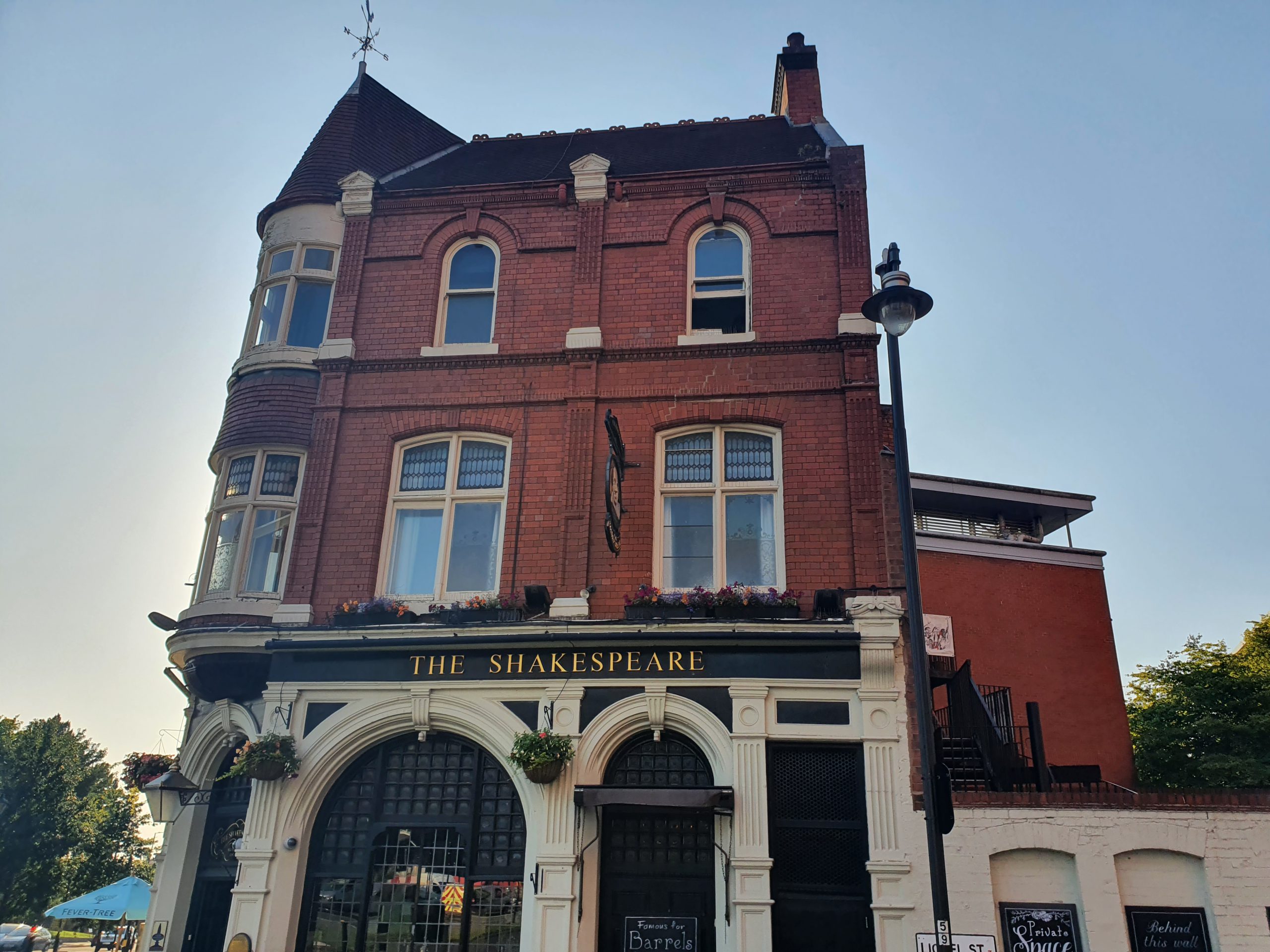
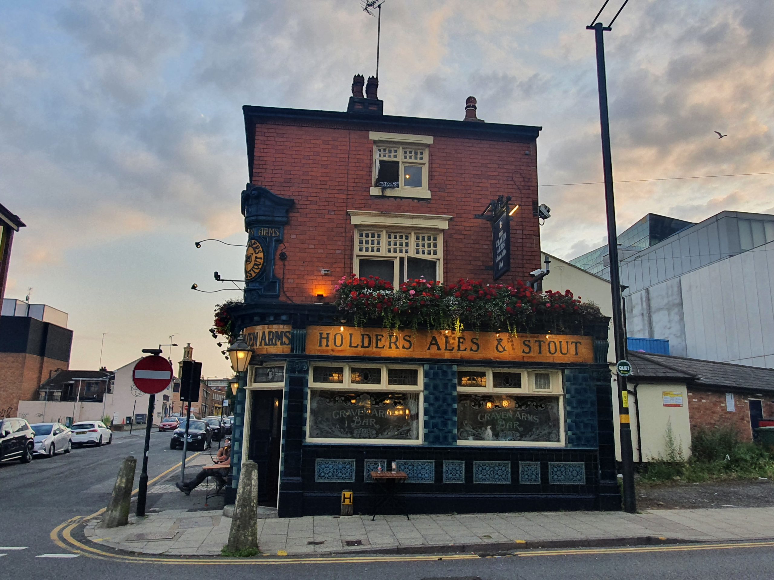
Blog

  • Saloon Bars and Public Bars

    Saloon Bars and Public Bars

    This article was published fifty years ago today in the Birmingham Post and there’s an element of this being a watershed in the evolution of British pubs. The distinction between the public bar and the lounge (or saloon bar) was being removed and women were being encouraged to visit pubs, although there was some considerable way to go on that at the time. It meant that prices were being standardised across the two areas of the pub, and being realistic, that usually meant a price increase.

    John Gilbert, the Labour MP for Dudley, wasn’t best pleased by all accounts, saying:

    “Some people are being forced to drink in places more like ladies’ boudoirs, when all they want is to drink a man’s drink in a man’s bar”.

    He commented on the influx of plush furnishings, carpets, colour TVs and jukeboxes, suggesting that this was forcing up prices. And fair play on this, a decent pub even fifty years on doesn’t need plush furnishings or carpets, and it certainly doesn’t need a colour TV or jukebox. Gilbert also described himself as “modest drinker”, which is a phrase that I’d use about myself, he sounds a rather measured man.

    I quite like the response from Watney Mann, who the article noted owned 6,500 pubs:

    “There would be no point in a pub on Park Lane having a public bar, but down by the docks it would be a necessity”.

    As an aside, Watney Mann were the brewery who produced Red Barrel, not a product that would ever be called a craft beer, let’s say that. Indeed, they were probably pushing it calling it a beer and there’s an interesting article elsewhere about that. But without breweries such as this, maybe there wouldn’t have been a CAMRA…..

    So, perhaps there’s something about the democratisation of the pub here, the removal of the class barriers between the different sections of the pub. I’ve seen articles written about how locals would ensconce themselves in the public bar, meaning that visitors would be encouraged to use the lounge bar. And that wouldn’t play well with how pubs are marketing themselves today, which is to a wider audience and not just to a small bunch of locals.

    I normally rail against change, especially when pubs, railways or crisps are concerned. But here, I think the right decision was made, a pub for the many, not the few…. As for John Gilbert, he was probably right that pubs didn’t need this wave of plush furnishings and maybe chains like Greene King even today could focus more on the beer than their pub interiors, but I’m not convinced that every pub needed a public bar. And the Government agreed, the letter that Gilbert sent to the then Home Secretary Reg Maudling was in vain, the dual bar set-up was coming to an end.

  • Carleton St Peter – St. Peter’s Church

    Carleton St Peter – St. Peter’s Church

    This is a remote little church in Carleton St Peter and this is the track which reaches it from the road. The parish is small with just a handful of properties, although there is evidence of prehistoric, Roman and medieval activity in the area. It seems that the villagers have just moved away since the medieval period, which makes the survival of this church all the more remarkable.

    Although there was a church here in late Saxon times, the currently building primarily dates from the thirteenth and fourteenth centuries, with numerous later additions. There are some early Norman features in the building, namely some lancet windows, which have likely been kept from the earlier structure and built into the fabric of the current church.

    An older infilled window, likely Norman.

    The chancel with no windows here on this side of the church, although it’s hard to see from the outside where it joins to the nave, as there’s a continuous slate roof.

    The tower is later than the main fabric of the church, dating to the early sixteenth century, with construction perhaps halted at one point which is evident from the different stonework.

    The polygonal stairs on the church tower.

    The churchyard, with a plot dug for a burial, and the area is quite open and spacious. There was an article in the Lowestoft Journal in 1876 which mentions when Edmund Perkins Hytton was buried in a vault in the graveyard, with his sister, Deborah Perkins Hayward, being buried in the same vault when in 1891 she died at the age of 97.

    The crossed keys of St. Peter on the stonework.

    Unfortunately, this is a church that is currently locked, although the Church of England say that it will open during daylight hours when some form of normality resumes. The porch is nineteenth century and likely replaced an earlier one, but there’s some history to that wooden door and it dates to some time in the medieval period.

    There’s an information board at the entrance to the porch and this notes that the church still has its King James Bible from 1611, which they refer to as a ‘Black Bible’ as it was without colouring (I haven’t heard of that term before). I’ve heard of the Great She Bible and these crop up from time to time, such as in the parish of Gisburn in 2015.

    A tithe map from the 1840s which shows the location of the church, and also how there’s nothing more than just a path to it. And therein lies the beauty of this church, a rural building unburdened by traffic and as familiar today as it would have been to the congregation of 500 years ago. And, hopefully, it’ll still look nearly exactly the same in another 100 years.

  • Dictionary of the Vulgar Tongue – Day 290, 291 and 292

    Dictionary of the Vulgar Tongue – Day 290, 291 and 292

    The Dictionary of the Vulgar Tongue was first published at the end of the eighteenth century, and given that the current health crisis is giving too much time to read books, I thought I’d pick a daily word from it until I got bored…. And to catch up after getting behind with these posts, and because I’m getting towards the end of the book, I’m doing three days at once now. How lovely….

    Rigmarole

    This is defined by Grose as “roundabout, nonsensical. He told a long rigmarole story”, and it was a phrase that would have been new at the time as its earliest recorded usage is from the middle of the eighteenth century. Oxford Languages Dictionary gives an explanation of the origins of the word, which is “apparently an alteration of ragman roll, originally denoting a legal document recording a list of offences.

    Google Ngram helpfully charts the popularity of the word over the last couple of centuries, it’s perhaps a strange word that has persisted in usage as it’s not necessarily easy to spell. In around 1880, the alternative spelling of rigamarole comes into usage, which remains relatively common today.


    Roast and Boiled

    Back to the military with this definition, which Grose gives as “a nick name for the Life Guards, who are mostly substantial house-keepers; and eat daily of roast and boiled”. The Life Guards are a regiment in the British Army and their heritage goes back to the middle of the seventeenth century. This web-site has details of other nicknames that the regiment managed to acquire, which included The Bangers, Lumpers, The Cheesemongers, The Fly-slicers, The Piccadilly Butchers, The Ticky Tins, The Tin Bellies and The Patent Safeties. That’s quite an impressive list of nicknames that they’ve secured for themselves….


    Romeville

    A short and concise definition here, simply given as “London, cant”, with cant meaning the criminal community. This sounds all rather exotic, but there’s an alternative version from the eighteenth century which is “Rumville”, although ‘Rum’ here means good. Although there are different spellings, the meaning was the same, which was the canting community felt that London was a city of great opportunity to them. The word fell out of usage in around the 1850s, although New York then took on the same nickname. I think I quite like the idea of London being referred to as ‘Rumville’ though…..

  • GeoGuessr (Norwich Version) – Walk 4

    GeoGuessr (Norwich Version) – Walk 4

    I already have a better explanation (well, longer explanation anyway) for this plan. In essence, whilst lockdown is on, I need to find ways of walking nearby to Norwich in quiet areas for my LDWA 100 training. So, I’m using GeoGuessr to pick out five random locations within a certain area which I’ve defined and then walking to them, to see what kind of story I can uncover.

    This walk was with Liam and the five locations that we got are above.

    We didn’t follow the Komoot route exactly and it came in at just under 18 miles, a rather useful training walk for the LDWA 100 and managing to avoid people for the vast majority of the day. We were fortunate in that our three locations outside of the city centre were all located in the same sort of area, as it would have made for a much more challenging expedition if just one had been off towards the east of Norwich.

    We started the walk going through Old Library Wood in Norwich.

    Our first location, which was 83 to 87 King Street, which has been much tidied up since George Plunkett took a photo here in 1985.

    By a lucky coincidence we managed to walk past a Greggs en route to our second location.

    A sausage roll and a latte, rather lovely.

    And the second location, showing the Guildhall and Tesco Metro. The Guildhall dates from 1413 and has been an important municipal building over the centuries and was used as the meeting place for Norwich City Council until 1938 and Norwich Courts until 1977.

    Some colourful graffiti in the underpass which stands roughly where the Bull and Butcher pub was once located before the inner ring road ploughed through the area. I hadn’t realised how much graffiti there is here, at least it’s quite artistic and not just random swear words scrawled onto a wall.

    I had a quick pop into Earlham Cemetery for this photo….

    I hadn’t noticed this before, a milestone from when this route was once a toll road leading from St. Benedict’s Street in Norwich to the metropolis of Dereham. The route was 16 miles long and the road was a turnpike between 1770 and 1872, when the tolls were removed. I assumed that this was a modern replacement, but it’s actually from the fourth and final set of milestones which were added by the Turnpike Trust in 1868. The metal plate is recent, as is the white paint which has been added over the stone. Each to their own, but having seen a photo of what it was like before the restoration, I preferred it as it was as I like history being raw and authentic (and yes, I know it’s just a stone and talking about it being raw is perhaps excessive….).

    A few weeks ago, Nathan and I walked here trying to trace the source of the River Wensum and when we were walking in this area off Hellesdon Road we saw some parakeets. Liam and I tried to spot some, but unfortunately failed….

    And another milestone. Ignoring the modern metal plate and the patchy white paint, the beauty of the original stone can still be imagined.

    And our third location in Bowthorpe, which didn’t really require walking far from the Dereham Road.

    We then walked from Bowthorpe to Costessey, this photo shows the Wensum Valley in the background. There’s what I consider to be an appalling attack on the countryside here proposed by Norfolk County Council, but fortunately the Stop the Wensum Link are working hard to end this environmentally disastrous project.

    This next stretch wasn’t entirely ideal, rather mountainous.

    A decorative datestone on this building on West End in Costessey.

    Slightly annoyingly, this photo doesn’t show how steep I thought the hill was here.

    Walking through the woods….

    We then came out into Queen’s Hill, a relatively new housing development located between Costessey and Taverham. The estate, according to the EDP, has 1,784 homes and 5,000 residents and despite people living there for ten years, they’re only now building their first shop, a Co-op which will open in late 2021. It felt a safe area to be, all quite middle-class and content, but I was surprised to see just how tightly the developers have packed the houses in.

    Public transport to Queen’s Hills isn’t ideal, there’s no train or light rail (the council didn’t seem bothered about this when they gave permission for thousands of homes to be built), and the bus stops have an absence of any information. I mentioned the Wensum Link above, the county council seem almost bemused as to why there is so much traffic in areas like this, it’s almost a mystery given that there’s limited public transport…. Anyway, I won’t grumble….

    A rather sweet little shed, which I think was a book swap location, with the house behind it having an artistic display in their windows.

    These four photos are from where cars have splashed water up against the hedge, creating a rather impressive little ice display. I was quite transfixed by the whole thing, although I’m easily pleased to be honest….

    [The River Tud, which is a future expedition for Nathan and me…..]

    Writing later on, this wasn’t the Tud (which is an off-shoot of the Wensum), this is the River Wensum…..

    Unfortunately, the bridge at the entrance to Taverham isn’t listed, so I can’t find out much about it. There’s an access point for firemen to attach hoses to the river though jutting out.

    And another view from the bridge, all rather scenic.

    Entering Taverham we thought we’d better get some lunch, and the chip shop here was well reviewed and it seemed only appropriate to pop in. I took this photo after eating chips, which might be noticeable from the smears on my phone’s camera……

    Friendly service, no facility to accept cards (my perennial complaint) and the prices marginally above average. All fine, nothing exceptional, but perfectly good value for money so nothing to complain about with the food. Liam had to wait for more chips to be prepared for his order, and I think the staff member seemed confused when I said to leave them unwrapped (most people don’t want to walk along an icy road in the cold eating chips perhaps) and I then realised he forgot to add the salt and vinegar.

    The Post Office looks like it does lovely fish and chips…..

    And our fifth and final location in Taverham.

    After some surprisingly slippery roads in Taverham, we decided to get back to Norwich by walking down the Marriott’s Way, the former railway line. Not very original perhaps, but it’s an easy walk back into the city.

    A bridge over the River Wensum, I’m not sure what that unsuitable surface on the bridge is.

    There’s still a lot of flooding in the fields nearby to Marriott’s Way.

    A variety of faces on some trees.

    All rather peaceful….

    This is Dragon Bridge on Marriott’s Way,  and there’s a story about a little train incident that happened here which is best told at Marriott’s Way web-site.

    And the end of the walk, with Gas Hill (Mountain) being closed off to traffic, a common occurrence in the mountain tops of Norfolk.

    So, the end result was that neither of us fell over on the ice, which was a major achievement in itself. The temperature was moderately warm, which was helpful, and it was useful to get some walking distance in for the LDWA 100. There were some areas of the city that I hadn’t seen before, mainly around Queen’s Hill and Taverham, so it was useful to see something new.

    As for the whole concept of these five random locations….. I still really like it, as the element of the random forces some exploration in areas that I might not think about ever visiting and it is quite handy at ensuring I can visit new chip shops in the Norwich area….

  • GeoGuessr (Norwich Version) – Walk 3

    GeoGuessr (Norwich Version) – Walk 3

    I already have a better explanation (well, longer explanation anyway) for this plan. In essence, whilst lockdown is on, I need to find ways of walking nearby to Norwich in quiet areas for my LDWA 100 training. So, I’m using GeoGuessr to pick out five random locations within a certain area which I’ve defined and then walking to them, to see what kind of story I can uncover.

    The five locations, which were conveniently all relatively central, meaning that walk wasn’t too long. Which was handy as I have an inability to walk on anything vaguely icy without sliding over and there was no shortage of ice in the city centre.

    As can be seen, the five locations didn’t make for a long walk, so trying to make this sound like an adventure is going to be quite challenging….. It’s more of a plod around Norwich, but I shall do my best….

    Two wooden sculptures in Old Library Wood, an area of the city much improved now that a community project has been set up to improve the park. It’s been really successful and it’s a much more pleasant area to walk through now than it was.

    And, after about three minutes of walking, here’s the first location, which is outside Norwich railway station. Just for those interested, Norwich railway station still doesn’t have a Greggs, whilst Ipswich does. I don’t get much involved with rivalry between cities/towns, but, as Viz would say, sort it out Norwich…..

    Norwich Railway Station was formerly known as Norwich Thorpe Station, when the city was fortunate to have three railway stations, the others being Norwich Victoria (opened in 1849) and Norwich City (opened in 1882). Norwich Thorpe opened in 1844, but the current building dates from 1886, both of which are visible in the above map from 1884. The top building of the two is the one that was being constructed when the map was produced, the one below it is the original and this has now been demolished.

    And our second location wasn’t much of a walk, located next to Norwich City Football Stadium at Carrow Road. Note the icy pavement and the road which was entirely free from ice. I take the radical view that if the council can’t clear the pavements, then pedestrians should just walk on the road instead. However, car drivers don’t much like this approach if I’m being honest.

    Crossing the River Wensum on the Julian Bridge, named after St. Julian’s Church and Lady Julian.

    The still closed Queen of Iceni pub and I’ll be glad when this, and other licensed premises, can re-open…..

    Who says Norwich isn’t hilly? Down the steps is the war memorial commemorating those who workers from Bullards Brewery, Morgans Brewery, Steward & Patteson and Youngs, Crawshaw & Youngs who lost their lives fighting for their country. There’s more about this at https://www.warmemorialsonline.org.uk/memorial/197721/.

    Our third location isn’t accessible at the moment as there’s work underway at Norwich Castle, so the area in front of the building has been closed off. They’re spending £13.5 million on the castle’s renovation and this will restore it to something more like its twelfth century appearance.

    As as aside, being slightly controversial (again, although perhaps grumbly is another word more appropriate here), I fear that this will lead to further price increases, which had already hit near enough £10, with surcharges made for visiting certain parts of the building. Although those who are so inclined to visit museums seem broadly pleased when they visit, I’ve heard too many people over the years refuse to go or to take their children on the grounds that it’s too expensive. Anyway, enough grumbling for now.

    Crossing the city centre we walked by Norwich City Hall, completed in 1938 and unfortunately destroying tens of interesting buildings which were on the site.

    St. Giles on the Hill Church and I mention its full name as a reminder of just how many hills there are in this city.

    The Roman Catholic Cathedral, built from the 1880s on the site of the former Norwich City Gaol. I won’t linger on the details of this building for long, it has appeared on a few of my walks recently…..

    Fortunately, the locations on our route meant that we went past the chip shop on Stafford Street, handily called The Chip Shop. As another slightly grumbly comment, although I’m pleased to note that the number of chip shops refusing to take cards is falling (albeit slowly), this one remains steadfast in their opposition to customer convenience and only takes cash.

    The arrival of my chips……

    The portion of chips here looks very small, but that was a combination of how they were wrapped and how closely I was holding them. The portion size was though generous and the battered sausage was a rather lovely complement to them. They came to £3 each, which is a bit above the average for Norwich, although hardly excessive given the quality.

    Our fourth location was Northumberland Street, a road which hasn’t changed a great deal over the last century in terms of the buildings. I don’t know the background for this street’s name, so I’m going to make up the best reason that I can. One of the biggest influences on building in the city in the nineteenth century was the Unthank family, which many Norwich residents will recognise due to Unthank Road. This family was from Northumberland, and their ancestral of Unthank Hall is still there. There might not be any link at all, but this is the best reason that I can think of, so that’s what I’m going with until gives me a better explanation.

    Our fifth location. This was handily in the area of St. Martin’s, meaning I ‘treated’ Nathan to a mini history walk around the area of the Tabernacle.

    This wasn’t a particularly long walk, slowed down only by my carefully walking in areas of ice (Nathan made some reference to Bambi which I ignored), which makes it hard to make a fascinating story of this little adventure. But, to be fair, there were chips involved in proceedings and that made it all worthwhile. Given the ice situation though, it was perhaps fortunate that this wasn’t an overly long expedition.

  • Norwich – Rosary Cemetery (Alfred Edward Hubbard)

    Norwich – Rosary Cemetery (Alfred Edward Hubbard)

    Alfred Edward Hubbard was born on 22 June 1889 and was baptised on 16 July 1889 at St. Peter Parmentergate in Norwich. He was the son of George Hubbard, who worked as a telegraph clerk, and Bertha Hubbard. The family lived on Synagogue Street, a street off Mountergate sadly now lost, although George Plunkett has a photo of how it looked.

    Alfred was one of a large family, at the 1891 census he had older brothers Frank, Charles and Harry, along with older sisters Alice and Bertha. Tragedy hit the family in the 1890s with the death of George Hubbard, meaning that Bertha was left alone to support her family. A later census noted that she had six children and they were all still alive, which wasn’t all that common, often children died young.

    At the 1901 census, Bertha ran a lodging house at 88 Chapelfield Road, living with her children Frank (working as a carpenter), Alice, Bertha (a pupil teacher), Henry (a clerk) and Alfred. By the time of the 1911 census, the family had moved to 73 St George’s Street, including Bertha and her children Frank (working as a carpenter), Alice, Bertha Constance (a teacher employed by Norwich City Council), Harry (a brewer’s clerk) and Alfred (now working as a teacher employed by Norfolk County Council).

    In early 1915, Alfred married May Mann and they lived on Yarmouth Road in Caister-on-Sea. He joined the Norfolk Regiment, service number 15653.

    Unfortunately, Hubbard’s war records are amongst those which were destroyed in an air raid during the Second World War, but he was in the 7th Battalion, which was formed of volunteers, also known as Kitchener’s Army. Alfred was injured in Hulluch, in northern France, in October 1915. The regimental records written in the field survive, although Hubbard isn’t specifically mentioned, but the above image is from that battalion in the Hulluch area from earlier in October 1915, showing the scale of the losses.

    Copyright Imperial War Museum (45786).

    This image is posted on Wikipedia, showing the state of the area between Loos and Hulluch in 1917. The British trenches are on the left, the German trenches on the right, with a now heavily damaged road going through them.

    Alfred died on 19 December 1919, at the age of 30, likely because of the injuries occurred during the First World War. The inscription on his gravestone reads “having fought a good fight in life and war, rest on”. There aren’t that many burials of the war dead at the Rosary Cemetery in Norwich, they’re mostly at Earlham Cemetery, so this stood out amongst the nearby graves. The uniformity of war graves ensures their visibility in a graveyard, and is a reminder that in death everyone was equal regardless of rank.

    It’s hard to imagine what Alfred’s brothers and sisters must have thought when standing at his graveside in late December 1919, it’s a far cry from the time of the 1911 census when they were all embarking on their new careers. And Alfred’s new career as a teacher was cut short, fighting a battle in a country to which he might never have otherwise visited.

  • Dictionary of the Vulgar Tongue – Day 287, 288 and 289

    Dictionary of the Vulgar Tongue – Day 287, 288 and 289

    The Dictionary of the Vulgar Tongue was first published at the end of the eighteenth century, and given that the current health crisis is giving too much time to read books, I thought I’d pick a daily word from it until I got bored…. And to catch up after getting behind with these posts, and because I’m getting towards the end of the book, I’m doing three days at once now. How lovely….


    Reverence

    I feel that I can add nearly nothing to this definition from Grose:

    “An ancient custom, which obliges any person easing himself near the highway or footpath, on the word Reverence being given him by a passenger, to take off his hat with his teeth, and without moving from his station to throw it over his head, by which it frequently falls into the excrement; this was considered as a punishment for the breach of delicacy. A person refusing to obey this law, might be pushed backwards. Hence, perhaps, the term Sir-Reverence.”

    The ‘Sir-Reverence’ lingered on in the English language, meant as an apology in advance for what someone was about to do or say. That’s all that needs writing here….


    Rhino

    Nice and simple definition this time, especially given Grose’s meanderings with the above, simply meaning “money” and it was used by the canting, or criminal, fraternity. This word has been used since the early sixteenth century as a slang for money and no-one is quite sure where it originated from. It might be that rhino horn was expensive, it might be that rhino was seen as an bulky and expensive thing (and the rhino would have been a relatively new concept for westerners at the time) or it could be from the Greek meaning of the word rhinoceros, which is “relating to the nose” as someone paying through the nose (another old phrase). And Green’s Dictionary of Slang adds another possibility to the mix, which is “clipping of SE sovereign; the term moved f. Und. to general slang, in mid-19th century”. So, in short, no-one knows, and this meaning of the word became archaic in around the late nineteenth century.


    Riff Raff

    I use this phrase from time to time (I won’t name the friends I have in mind), defined by Grose as “low vulgar persons, mob, tag-rag and bob-tail” and it hasn’t much changed its meaning since the dictionary was published in the late eighteenth century. The phrase is from the late fifteenth century, it’s a corruption of the old French “rif et raf” meaning “one and all”, so there’s some heritage to this.

    Although there’s a long history to this phrase, it’s only recently that it has become more commonly used. I suspect that some of this is related to the Rocky Horror (Picture) Show from the 1970s onwards, where Riff Raff is one of the characters.

  • London – Greenwich (Borough of) – National Maritime Museum (Guillotine Blade)

    London – Greenwich (Borough of) – National Maritime Museum (Guillotine Blade)

    This exhibit, which I accept isn’t the cheeriest, is in the collections of the National Maritime Museum in London. It’s a guillotine which dates from around 1792 and it was used on the Caribbean island of Guadeloupe to execute about 50 royalists.

    I have to say that I’m not sure I’d have wanted to live on Guadeloupe in the late eighteenth century. It was French until 1759, when the British took it over, but the French really liked having it. The French decided that they wanted it so much that at the Treaty of Paris in 1763, they swapped their French colonies in Canada to keep control of it, so they took over the island again. The French Revolution, which really wasn’t ideal for the wealthy in France, also spread to Guadeloupe and everyone was made free on the island, regardless of their colour. The British decided that this political power vacuum was a chance to get the island back, so they invaded in 1794 and gained control, only to see the French quickly take it back.

    The guillotine was likely taken over by Victor Hugues when he went out to try and purge the Royalists and set the country free from the British who had interfered with arrangements. Hugues arrived on the island with his guillotine on 2 June 1794 along with 1,153 Republican soldiers who were keen and eager to fight and kill people. Documentation mentions that those killed included the estate owners on the island, as well as some military officers, and the guillotine was carried around the island as further victims were sought.

    It is said by the National Maritime Museum that Captain Matthew Scott of the Royal Navy decided that it seemed an ideal souvenir, so he brought this guillotine back on HMS Rose when the British left the island. I can understand why Captain Scott took the item, as he might have thought it was something important politically, but Hugues attacked and pushed the British off the island, so it’s unclear why Scott would have this guillotine. It’s unlikely that Hugues would have willingly given it up (Paul Fregosi in his book Dreams of Empire said that he was very attached to it), as he still had work to do with it.

    And the next part of this mystery, HMS Rose sank near Jamaica on 28 June 1794, so I have some queries about this situation as well….. It’s clear that Scott hasn’t sailed home with it and come back, as there wasn’t time, so that guillotine would have been on board when the ship sank. The 200 sailors on board had to fashion bits of the ship to create rafts to paddle to safety, this wasn’t some little incident in the harbour where they had chance to reclaim everything. I’m unsure whether someone decided that the guillotine needed salvaging as some sort of priority, was Scott that keen to have it?

    So, there’s perhaps something slightly wrong about the story told by the National Maritime Museum and my theory (based on no evidence at all) is that Scott did bring this item back, but that he did so later on. Scott later became a Vice Admiral and he was still on board ships in the region in 1810, the year that the British took back Guadeloupe. So, my historical guess (like this is of relevance to anyone) is that Scott brought back the guillotine as a war trophy at this point, and not before. And I am unanimous in that to quote Mrs Slocombe….

  • GeoGuessr (Norwich Version) – Walk 2

    GeoGuessr (Norwich Version) – Walk 2

    I already have a better explanation (well, longer explanation anyway) for this plan. In essence, whilst lockdown is on, I need to find ways of walking nearby to Norwich in quiet areas for my LDWA 100 training. So, I’m using GeoGuessr to pick out five random locations within a certain area which I’ve defined and then walking to them, to see what kind of story I can uncover.

    So, this was the second of these walks, this time Nathan was dragged out to walk in the dark. We were using a map which used the ring-road as our limit, simply for time reasons, although we did manage to get the B&Q right on that line. Tonight’s little expedition was 11.2 miles, in the rain……

    This was the start of the walk, there really was no beginning to our bravery tonight…..

    Once we had summited Gas Mountain, we had a little rest and looked back down towards the city of Norwich, nestled in the foothills. We had walked around thirty metres at this point.

    My local voting station. How lovely.

    The Gordon pub, which I haven’t visited for a while, it’s a reasonably popular community pub though.

    And we reached our first location. We didn’t make much effort to match the photos up exactly, life’s too short…. Well, actually, it doesn’t seem too short to do this walking thing, so perhaps we could have made more of an effort.

    Past Thorpe St. Andrew School and I had a look on Wikipedia to see which former pupils went there. There are four listed and I haven’t heard of three of them, but I have discovered that Ben Bradshaw MP went to school there.

    In the diminishing light we strolled into some woods, which wasn’t perhaps ideal. The inaugural tree at Queen Elizabeth II Woods was planted by Chloe Smith, another fascinating fact that people should know.

    The second location, which wasn’t lined up at all, primarily as I didn’t want to stand outside someone’s house at night taking photos.

    Nathan had just spent thirty minutes complaining that he couldn’t get his phone to display the map, so I led us efficiently during that time. In a crisis, I’m always calm and reassured. Then Nathan, after a fit of pique, announced that he had worked out how to turn his phone on (or whatever he was faffing about doing) and he would lead us. So, here we went, entering some park with minimal lighting.

    The “please consider” is perhaps in vain, the careful and caring dog owners would anyway, and those inconsiderate ones won’t. Always worth a try though, passive aggressive signs can work.

    Remember I mentioned that Nathan was in charge of navigating? He found the muddiest path in Norfolk to walk down in Norwich City Centre, which isn’t generally known for its muddy paths. I didn’t complain though.

    After walking miles through a sea of mud, we decided that a road might be nice. This is the Norfolk Regiment War Memorial, located near to Mousehold Heath, and I’ll take a better photo in the day as this warrants that.

    The Rishi Indian, which was the Duke of Norfolk pub between 1938 and 2009, re-opening as a restaurant in 2011.

    We then popped into the Co-operative, and their beer selection wasn’t entirely dreadful. But, I wasn’t sufficiently tempted and I couldn’t be much bothered to carry it. Tonight didn’t feel like a drinking night, although I suspect the next walk might well have a few craft beer delights along the way.

    I could though be bothered to carry my five custard doughnuts for 21p that I found in the reduced section. Not that I had to carry them for long if I’m being honest, they were very moreish.

    Nathan, who is much more decadent than me, splashed out 34p on sausage rolls. We had been intending to get chips, but this seemed satisfactory under the circumstances.

    The third stop was the B&Q car park. It’s not ideal is it? But, we have to get walk training in for the LDWA 100, so this is as good a place as any. There were a fair few people around at B&Q, but we couldn’t much complain about that whilst standing in the middle of their car park. On the bright side, we walked past nearly no other pedestrians, just a few joggers.

    Walking back into Norwich city centre, these are the houses looking out onto St. Augustine’s Church.

    Our fourth location, which was sort of lined up, this is St. George’s Street.

    I faffed about taking photos of this willow tree, located by the River Wensum.

    St. Andrew’s Hall and Blackfriars’ Hall, the scene for one of my highlights of the year, Norwich Beer Festival held at the end of October every year. Fingers crossed that this year’s can go ahead, I’m missing doing my annual volunteering effort at glasses and tokens.

    Tombland road works, there were toilets here, but they’ve been removed. I had expected the council to be building another car park, but they’re creating some open space (which will likely happen to have cars parked on it if the council get their way). The council spent some money a couple of years ago putting in traffic lights for cyclists, but they’ve been ripped out.

    And our fifth location and we could have had much worse than Norwich Cathedral Close which looked rather beautiful in the fading light. Incidentally, it was actually pretty dark, my phone was in night setting and the images look much lighter than the reality.

    St. Ethelbert’s Gate, built in 1316 and still maintaining its beauty.

    And I couldn’t resist a photo of Norwich Cathedral, taken from under the Erpingham Gate.

    That concluded this little adventure, which we did at quite a fast pace. Given how quickly the whole evening went, it’s given us some more confidence about the 100, that if we can just gossip and complain about our friends for 40 hours or so (this is quite likely) then we might just get round. Well, maybe.

  • Norwich History by Parish : St. Martin at Palace

    Norwich History by Parish : St. Martin at Palace

    And a new little project that Jonathan and I are undertaking because this lockdown is clearly here for at least a few more weeks. It’s a bit niche (our project I mean, not the lockdown), I’ll accept that, but there we go. Effectively, it’s walking around Norwich, ancient parish by ancient parish and seeing what is there now compared to a map from the 1880s (the map above is from 1789, but the one from the 1880s is more detailed, which is why we used that). There’s a PDF of these boundaries to provide some extra background to this whole project. Our first parish was St. Helen’s and this is the neighbouring parish of St. Martin at Palace.

    The precise ward boundaries are in the PDF above, but this is the area of Norwich that we had a little meander around.

    This is an area that neither Jonathan or I were aware of, despite my having walked by it hundreds of times. It’s located in front of the courts complex in Norwich and it’s the former site of the Tabernacle. This church, which held 1,000 people, was opened in 1753 and there’s plenty of information about the history of the building at https://ukwells.org/wells/the-tabernacle-norwich.

    The 200th anniversary of the building wasn’t the most fortunate, as it was entirely demolished in 1953 as it had fallen into a state of disrepair. The demolition was perhaps a mistake, this would have remained an interesting and quirky building if it had been allowed to stand. George Plunkett has a photo of what it looked like in 1941 and to give an idea of where it stood, that kerb on the bottom right hand side of the photo is where the Adam and Eve pub is located today.

    Nearly nothing remains of the Tabernacle, but this now quite damaged tablet is visible in the area where the house next to the tabernacle stood.

    Jonathan noticed a giant rat just before I decided I needed to have a look at this grave, but I braved the area anyway. There is very little I won’t brave for the sake of historical investigation. Well, not snakes though, I wouldn’t have gone in here if it had been ridden with snakes.

    This whole area of land is now used by the courts, but 100 years ago this was the site of a large gas works. The road in the foreground is modern, but at this end it follows the route of the old World’s End Lane. The area to the left is now just left empty, but this is where it fronts onto Bishopgate today, although the buildings that George Plunkett took a photo of in 1936 have been demolished. I’m really not sure that the courts need such a large car park, there’s definitely space for a Greggs or something here.

    This might not be much to look at, but underneath here is the Norman House (https://www.norwich360.com/normanhouse.html). I visited here on a Heritage Open Day, it’s well worth going to see for those who can, and I’ll put photos up in due course from when I went. Upstairs in the court area there’s also the Arminghall Arch.

    This is the Bishop’s Gate (and is where the street Bishopgate gets its name, although I think most people would guess that) which is Grade I listed and was constructed in around 1436. Just behind it is the new Bishop’s Palace, but this was also the entrance to the old Bishop’s Palace, today part of Norwich School.

    And I have managed never to notice this sizeable building which is attached to the Bishop’s Gate. This is a medieval barn and granary, although it was much changed in the eighteenth, nineteenth and twentieth centuries and is now offices. This also leads to the area where St Matthew the Apostle’s church once stood, long since demolished. The former churchyard, which was formerly left as a park, has now been built on by the council.

    St. Martin’s Vicarage, serving the church that this parish takes its name from and is located opposite, St. Martin’s at Palace Plain. The building dates to the middle of the nineteenth century, although there was another building here before that.

    St. Martin’s at Palace Plain church, which ceased to be used for services in 1971 and was later converted to be used by the Probation Service. It’s now used by the Norwich Historic Churches Trust as their base, and access is encouraged (well, not at the moment, but it will be again when normality resumes). There’s a George Plunkett photo of the interior from 1938, it’s quite a charming and well-ordered church.

    When the building was being converted to better suit its new office usage, which as an aside was done quite sensitively, there was an archaeological dig underneath the floor. This discovered that there were once two Saxon wooden churches on this site, with the foundations of the current church dating from the eleventh century. Most of the current structure dates to the fifteenth century, although following a little incident in the 1840s when the nave and chancel fell down (which wasn’t ideal), with a Victorian restoration of the structure. The slum clearances of the 1930s swept away much of the church’s congregation, so it did well to manage to survive as a working parish church until the beginning of the 1970s.

    The chancel wall, with the graves having been removed from their original place and shoved up against the church.

    A garage type arrangement, visible on the left of the photo, has been inserted under the churchyard. This road is now private access to the courts, but it was once the end of World’s End Lane, so effectively the church site was in the middle of a traffic island.

    The parish boundary takes in territory across the River Wensum, requiring a walk over Whitefriars Bridge. I’m not sure why it does this, I assume it was some medieval way of trying to balance out the population sizes between churches.

    All that remains of the Anchorite House, part of the Whitefriars Monastery, which stood here between 1256 and 1538.

    When younger, I thought that this was the National Coal Board building, which isn’t perhaps a bad guess. It’s actually the premises of Norwich Corrugated Board (well, Smurfit Kappa now, which goes to show that putting a company name on a building in brick isn’t perhaps ideal when the ownership changes) in what is an unusually large manufacturing building still in the centre of the city. More about this in the parish we visited the week after….

    The corner area here now has a modern building on it, but this was the site of a shoe factory a century ago. The street here is now known as Whitefriars, although it has historically been known as Cowgate. When the council smashed through the area with their new road, it split Cowgate into two, hence why this section has now been given the new Whitefriars name.

    This is Whitefriars Bridge, which has also historically been known as St. Martin’s Bridge. It was first constructed in around 1110, but this story is best told by the formidable George Plunkett (and he has a photo of the bridge from 1933):

    “Whitefriars Bridge is one of several in Norwich rebuilt during the 20c. Formerly known as St Martin’s bridge, it is first mentioned in a grant made by King Henry I to Bishop Herbert de Losinga shortly after 1100. In 1290 it was washed away by a great flood, and there are records of it having to be rebuilt at different times throughout the centuries. The earlier ones would have been wooden constructions; during Kett’s rebellion in 1549, we are told, the bridge was deliberately demolished with the dual purpose of impeding the rebels and using its timbers to strengthen the nearby city gates. In 1591 a more permanent edifice was built of stone, with a single pointed arch. This survived until replaced by the present bridge designed by Arthur E.Collins, City Engineer, and built by unemployed labour under a skilled foreman. It is of concrete reinforced by 1.5 inch steel bars and faced with mica quartz and white cement. The first half was opened to traffic on 19th February 1925. Its span of about 80 feet is some 50 feet wider than that of its predecessor.

    It was said at the time that the stones of the old bridge would be marked in order that it could be re-erected on a different site, but this was never done. Several suggestions have been put forward as to their fate, one of the least plausible being “that they happened to fall into a wherry as it passed under the bridge” and were conveyed by water to Wroxham and Horning to be used as foundations for riverside bungalows. It sees more likely that some at least were taken from the bridge to the Corporation Depot at Infirmary Square (now Starling Rd), and were later moved to another store at St Martin at Oak Wall Lane, finally ending up as foundations for roadworks on Aylsham Rd.”

    Now known as Quayside, this row of houses facing the river are around 100 years old. Although it wouldn’t have been possible at the time, there’s a path now along the river for those want to walk along it, a project which must have showed considerable foresight to establish.

    Pyes Yard, which has also been known as Fyes Yard and Pyes Court. In 1938, there was a slum clearance of the 17 houses down here, so everything of historic interest down to the river is lost. George Plunkett took a photo shortly before the area was condemned, which might have today made for some rather beautiful townhouses with a little (well, quite a lot) of modernisation.

    The old signage to the yard.

    The buildings facing Palace Plain have survived, even if the yards behind them have now been taken down. The white building on the left is 1 and 2 Palace Plain, originally built in the seventeenth century, then used as a shop before more recently being incorporated into an office building. The white building in the centre of the photo is what is historically known as the White Lion pub which has been a licensed premises from the mid eighteenth century and which was originally built in the sixteenth century as a residential property. When the courts were opened in 1985, the pub name was changed to the Wig and Pen, perhaps to tempt the wealthy lawyers and judges over. The red brick building on the right of the photo is Cotman House, originally built in the eighteenth century as a residential property.

    Cotman House is so named as John Sell Cotman (1782-1842) lived at the property. He was one of the artists who was part of the Norwich School of Painters, one of the first local art movements in the UK. The group was originally led by John Chrome, before Cotman took over to keep the informal movement going, although it fell apart a bit when he moved to London.

    The back of what was Busseys, the Ford car dealership, whose city centre land no doubt just became worth far more for building than it did for selling cars. The street that runs behind the back of these buildings, connecting Bedding Lane to Pigg Lane, is Joseph Lancaster Way.

    I’m not entirely confident that I know why this modern street has been given this name, so I’ll have to make a guess. The area behind Busseys was once a school and there is a Joseph Lancaster who was important in the nineteenth century for the establishment of more modern educational methods. He’s known for the phrase “a place for everything and everything in its place”, which makes him sound rather organised…. Anyway, I’ll probably find out that it’s been named after some local councillor, but that’s the best reasoning I’ve got as to the naming of the street.

    The building in the centre is 17 Palace Street, which dates from the eighteenth century, although the range stretching back a little at the rear is from the seventeenth century. The building next to it is modern and is where the entrance to Busseys once was, and George Plunkett has a photo of that from 1987.

    That concluded the day’s historical activities, we then went to try Ron’s Chips.