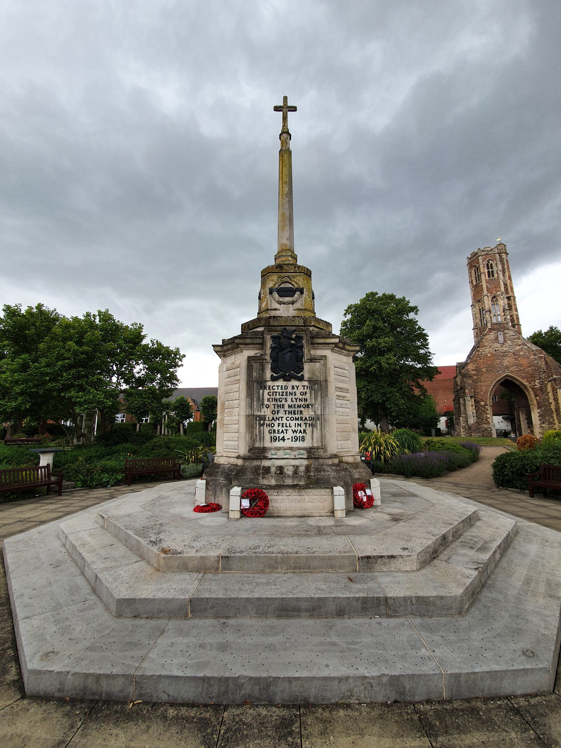
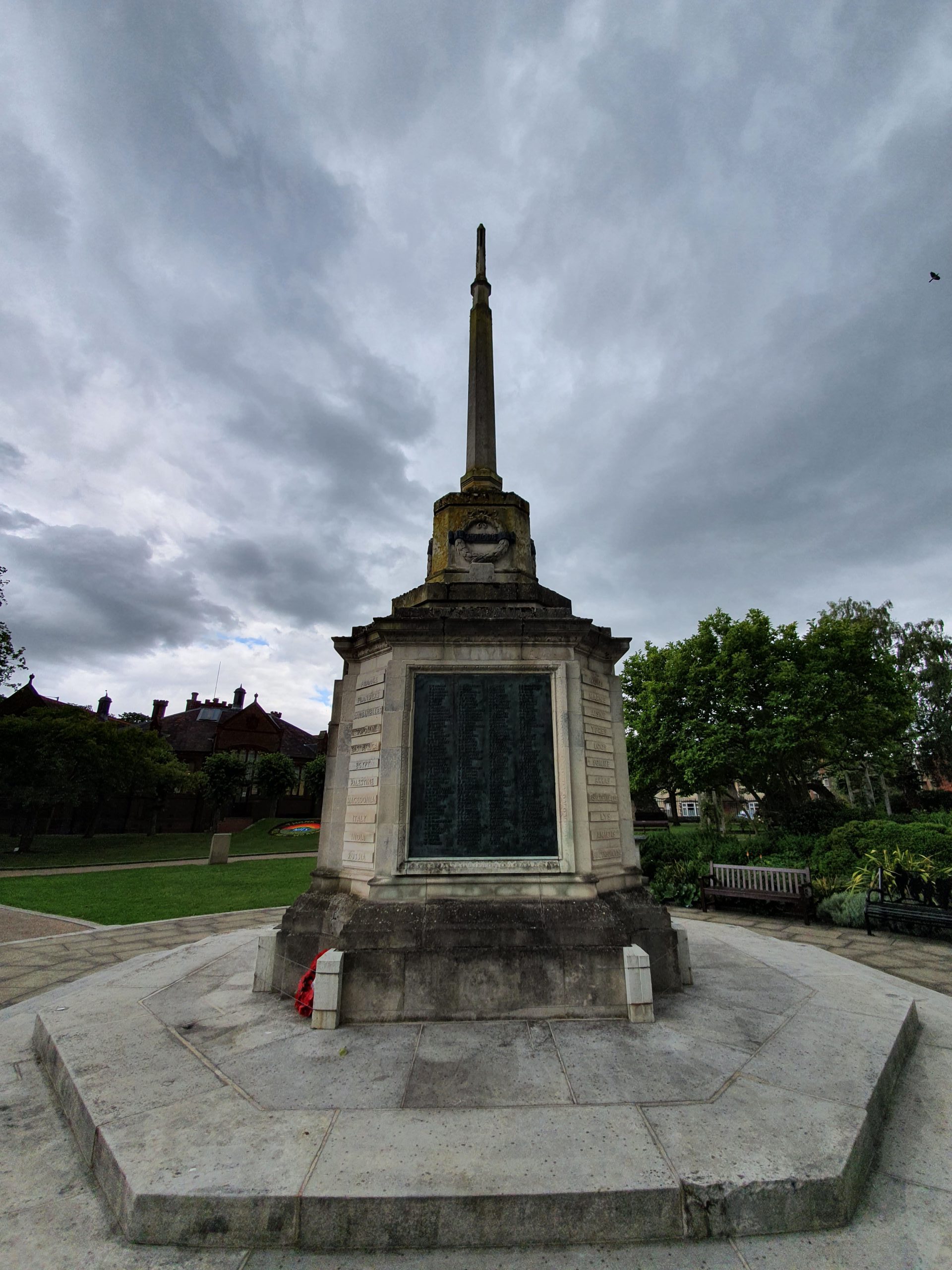
And that’s another restaurant in Norwich permanently closed, the Latin American themed Las Iguanas on Wherry Road. Located near to Coast to Coast, which also permanently closed a few weeks ago, Las Iguanas is closing as a result of the Casual Dining Group going into administration. A little surprisingly, both Bella Italias in Norwich are staying open, although many are closing around the rest of the country.
Category: Norfolk
-

Norwich – The Chip Shop (Stafford Street)
Not the most innovative of chip shop names, but I’ve heard positive things about this location and their reviews are broadly glowing in praise. Before I start, I’ll get my pet hate out of the way, which is businesses that don’t take cards. Although I have no complaint as they can run their business how they want, it means I won’t go back. The number of locations that don’t take cards is now so small that customers expect it, and in my view, local businesses need to fight back against the sea of monotony that is offered by some chains.
Indeed, Amex is running their usual December offer early, so any customer visiting a chip shop (or any small business which accepts Amex) with that offer will get £5 for free if they spend £10. More and more market traders are accepting cards and any business which doesn’t seems destined to need a large sign visible in their window or on entrance telling customers they don’t accept cards. And, that was the case here, the first marketing message in the shop was “cash only”. Although to be fair, the shop wasn’t quiet, the trade was steady.
The service was polite and efficient, with the social distancing system being a little unclear (over half the customers got it wrong), but the staff were verbally explaining it. The price for battered sausage and small chips was £2.60, which is below average and the portion of chips was substantial. There was a moderate customer service failing in that they wrapped the whole lot up, even though I wanted it unwrapped, and didn’t offer salt and vinegar.
But, the chips were excellent, fluffy on the interior, slightly firm on the exterior and they had a pleasant taste. The sausage content was a little generic, but it tasted fine and the batter seemed freshly made, was golden and had a richness of flavour.
So, I can understand why they have the reputation that they have, there’s a focus on the food and all seemed fine with perfectly good value for money. The locals are fortunate to have this chip shop here, it is clearly well respected in the area.
-

Norwich – UEA Walk
Just some photos in this post….. This is from our group walk which covered part of the lake at the UEA and some of their sculptures. More of these next week when we explore the rest of the lake and sculptures area.
Incidentally, the dog was rather sweet. He just sat in the lake like that for some time, the owner said that he was wondering if his dog thought that he was a crocodile.
-

West Lynn – West Lynn War Memorial
West Lynn’s war memorial is located within the churchyard of St. Peter’s church and was unveiled in 1920. It is made out of Bath Stone and there were 25 names from the First World War and 4 names from the Second World War. Over recent decades it has become harder to read the names on the memorial, so new black plaques have recently been installed to make the names clear. When these new plaques were added, historic research meant that 10 additional names were added from the First World War, bringing the total to 35.
-

King’s Lynn – The Norfolk Dumplin
Whilst looking at something else about King’s Lynn, I noticed this print (© The Trustees of the British Museum) in the collections of the British Museum.
This moderately bizarre image (click on the image to make it bigger) is an attack on Robert Walpole (1676-1745), and suggests that Edward Taylor was an illegitimate child of Walpole. I’m still slightly surprised, as this trick was commonly used in electioneering at the time, that the law allowed “W-lp-le” to hide the fact that the creator of the image wanted to highlight that he was referring to “Walpole”. Walpole, effectively the country’s first Prime Minister, was known to have had other mistresses, so the allegations aren’t necessarily false. The connection to King’s Lynn is that Edward Taylor was born in the town in 1703.
It’s not known who created the illustration, but it is dated to 1744 and the British Museum acquired it in 1868 from the estate of Edward Hawkins, a long-time curator of the museum. The term ‘Norfolk dumpling’ usually refers to someone who is a bit dense, although it’s also a culinary treat….
-

King’s Lynn – Etching by Henry James Stuart Brown from West Lynn
Yesterday, I posted some photos of King’s Lynn which were taken from West Lynn.
This 1928 etching (© The Trustees of the British Museum) was drawn from along the riverbank of West Lynn and shows the main buildings in King’s Lynn. It was drawn by Henry James Stuart Brown (1871-1941) who was known for this style of drawing and although he was overlooked during his own lifetime, his works have become much more collectable in recent years. He made numerous etchings in this part of the country and the British Museum have a relatively substantial collection of his prints, with Brown donating this work to the museum in 1930.
-

King’s Lynn – Whitefriar’s Gate Etching by William Taylor and William Pickford
I posted about the Whitefriar’s Gate, or Carmelite Gate, yesterday, and today I found this etching in the on-line collections of the British Museum (© The Trustees of the British Museum).
Dating from 1843, it’s quite atmospheric with children playing and chickens eating, and it couldn’t be much more different than the surroundings of the gate today, which is just quite a lot of barrenness. The image was drawn by William Pickford and was etched by William Taylor, with Taylor also being the publisher of the image. The plate isn’t on display at the British Museum, but they’ve owned it since 1876 when they purchased it from the art dealer Robert Jackson.
-

West Lynn – St. Peter’s Church
There has been a church in West Lynn since the late Saxon times, but it appears that the previous one was badly damaged by flooding and a decision was made in 1271 to abandon it. This means that this church was built in the 1270s, likely using materials from the previous church, and the tower is from the fourteenth century. There were reconstructions during the fifteenth century and the chancel is a more modern rebuild, from 1934.
The four-stage west tower.
The tower and the north porch.
The south porch.
The churchyard, with the chancel visible at the east of the church which looks quite squat, but which was once a little longer. In the early nineteenth century, a local author noted that the chancel was roofed with reeds, whilst the main church was roofed with lead, which would explain why that section became harder to look after.
The church did appear to be open when I visited, but given the current health situation I think they were trying to provide somewhere from locals to pray quietly rather than have people traipsing around looking at the older monuments, so I’ll go back at a more opportune time in the future.
-

King’s Lynn – Vandalism and Shopping Trolleys
Unfortunately, King’s Lynn appears to have been hit with a wave of vandalism and crime over recent weeks judging by the newspapers. And, this week someone smashed a load of new trees in one of the town’s parks, meaning they have to be dug up and removed.
There are also countless shopping trolleys dumped in the River Great Ouse.
-

King’s Lynn – Former A47 Road Bridge
Walking along the quieter of the two road bridges across the River Great Ouse (the other is visible in the background of the above photos), I wondered what the supports next to it once held up. I assumed it must be the rail bridge that I knew went near here, although that didn’t make sense as there were no signs of a former railway line at either end.
Two of the bridge supports.
This is the support on the north side of the river.
And, the answer is here (click on the image to see a clearer one). There are two bridges in the same place on the two maps, the first map is from the 1950s and the second map is a current one. On the first map, the top bridge is the A47 road and the lower bridge is the rail bridge. On the second map, the top bridge is now Wisbech Road bridge and the lower bridge is the A47 road. Confusing…. But, that’s why the remnants of the bridge are there, it was another carriageway of the A47, which was taken down when a new road was constructed when the rail bridge was taken down following the closure of the rail line in 1959. The route of the A47 was then changed to follow much of the former rail line, leaving the bridges as they are now.


