Category: Norfolk

  • King’s Lynn – St. James Chapel Burial Ground and a Cluster of Gravestones (Thomas Barlow)

    King’s Lynn – St. James Chapel Burial Ground and a Cluster of Gravestones (Thomas Barlow)

    This grave belongs to Thomas Barlow and is located at the relocated burial ground of St. James Chapel in King’s Lynn.

    I like this gravestone as it actually offers some information about Thomas, namely that he was a bookseller on the High Street. It’s a shame more graves don’t have a few more details such as this, or, even photographs as is much more common in some mainland European countries. Although I recognise that since Thomas was buried in the early nineteenth century that a photograph would be more challenging, but I meant for more modern burials. Anyway, I digress.

    Thomas was born on 18 March 1788 and christened at the Church of St. Margaret with St. Nicholas on 31 January 1789 and he was the son of William Barlow and Mary Barlow.

    Thomas opened his bookshop on the High Street in 1821 and advertised this in the local press. This made me wonder where the shop was and there’s a clue in the advert, as it mentions a “Mr. Servante”. He owned a linen shop on the High Street and this had previously been occupied by Robert Redwell, with this freehold being advertised in the local paper. The advert for the freehold of the property mentions that the premises came with a “dwelling house, warehouse, stable, yard, garden and shop” and that they were “located directly opposite Norfolk Street”. That, I think, puts it at somewhere like 74 High Street, where Bonmarche currently is.

    Thomas died on 2 May 1823 and was buried on 7 May 1823, but, unfortunately, the death wasn’t announced in any local press that I can find, so I don’t know the cause of why he died at the age of just 30.

  • King’s Lynn – St. James Chapel Burial Ground and a Cluster of Gravestones

    King’s Lynn – St. James Chapel Burial Ground and a Cluster of Gravestones

    Until 1903, this was the graveyard of St James Chapel (which had long since fallen into disuse as it was closed during the Reformation), although it had been closed to burials for some years. The area had been opened to burials from 1805, but there were also some medieval burials from when St. James chapel was still operating. It was decided that it would be beneficial for the town to use this space as a public park, although the Mayor added that it was primarily for the older population to relax and not for younger people to play in. I suspect that the town didn’t dislike younger people, they just felt that there was already sufficient provision in King’s Lynn for that.

    The gravestones were all bundled up and shoved in one corner of the churchyard, something that I was surprised was seen as acceptable in 1903. However, after reading newspaper reports from the time, it makes a little more sense. It transpires that, for whatever reason, the graves had already been moved about a bit before, so they had lost their original placement. Given that, the council thought that moving them again wouldn’t be problematic, but they promised to ensure that the stones would be treated with care and respect.

    The council also pledged to ensure that details of each of the graves were to be kept so that individuals were able to cross-reference the old and new locations. This documentation was to be placed in the town clerk’s office and it was felt that this care would be useful to the population of King’s Lynn and ensure that no information was lost in the move. I’m not really that keen on moving gravestones from where they were originally placed, but this action probably ensured that the stones remained better preserved since they’re all shoved close together and protected from the elements.

    Anyway, some more photos, and I’ve got some (well, a lot) of photos of individual gravestones as some looked quite intriguing and might interest me to write about in the future. The stones are, I think, all from between 1805 and around 1870, which is when the churchyard opened and closed.

  • Wymondham to Forncett Railway – The Swedes and Swimmers Line

    Wymondham to Forncett Railway – The Swedes and Swimmers Line

    The Wymondham to Forncett railway line was constructed between April 1880 and May 1881, allowing a connection between the Norwich to Cambridge line and the Norwich to London line. This was mainly for freight purposes, but there were passenger services also, with one station along the six-mile route, which was Ashwellthorpe railway station. Wymondham railway station had been open since 1845 and Forncett railway station since 1849, meaning this line only needed the construction of Ashwellthorpe, which opened in 1881.

    The line has since been nicknamed the Swedes and Swimmers Line, apparently after the food which the navvies building the railway were eating at the time. This was a combination of swedes, which aren’t particularly delicious in my opinion, and swimmers, which are Norfolk dumplings. I like the idea of naming lines after what the construction staff were eating and drinking at the time, the Crossrail line would be much better if it were called the Greggs and Coffee line.

    The service stopped for passengers in the days after the Second World War was announced and although it was only initially intended for the duration of the conflict, the trains never returned here for anything other than freight. The last freight service was on 4 August 1951 and the track was lifted in February 1952.

    Some of the line did last longer and I’ll quote the excellent page at Forncett History to tell the story:

    “A short two-mile spur of the line remained at the Wymondham end at Hethel until 1976 and in December 1954 this was used to stable the royal train overnight. The spur was subsequently used by Archie King for scrap railway carriages, the wooden superstructures being burnt before the steel undercarriage was broken up. Eventually the scrap dealer realised that there was a market for the more valuable pieces of ornament in the carriages, and they were removed before being torched. In 1967 the North Norfolk Railway rescued the Gresley Quad set of coaches from this scrapyard. In 1970 the actual carriage that had been robbed in the Great Train Robbery seven years earlier was burned here, in the presence of police and Post Office representatives, in order to avoid it becoming the target of souvenir hunters.”

    This is Wymondham railway station looking in the Norwich direction, and this railway line spurred off to the left around 250 metres down the line. There’s nothing left of the Swedes and Swimmers line today other than a few bridges, some destroyed bridges and lots of embankments along the route. One thing that became evident to me whilst looking at what was left is just how much soil had to be moved to create those embankments, who says Norfolk is flat?

    For anyone wanting to walk a section of the former line, a chunk can be reached by going down Lizard Lane in Wymondham. On my expedition along the railway line I was accompanied by Liam, along with the two younger railway surveyors, Dylan and Leon. They were very helpful indeed, although I think I might have exhausted them with railway history by the end.

    An information board about the Lizard.

    The railway embankment is visible at the rear of this photo, and there’s a circular path for those who want to walk around this area.

    This is where the railway line once connected into the Wymondham to Norwich line, now overgrown and also fenced off at the rear.

    The closed line is the one which goes off to the right on this map.

    This entire section is on a raised embankment, little changed other than they’ve entirely lifted the track and all evidence of it. Which is quite a bit change I suppose, but the embankment here is intact.

    This section of the railway ends here as the A11 has been built in front of it.

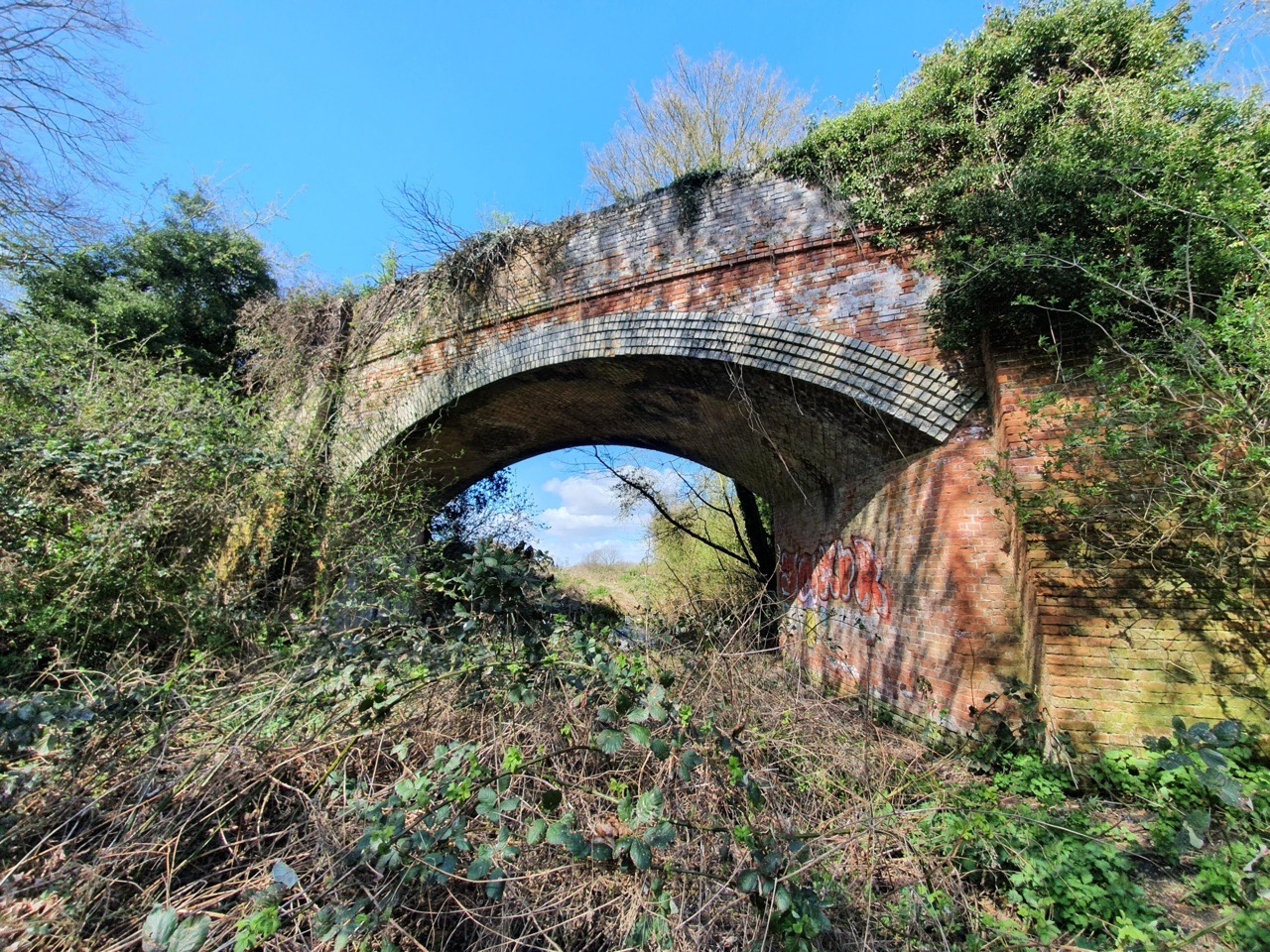
    The railway bridge here is intact and it’s possible to walk over it, although that requires fighting through bushes and brambles.

    The side of the bridge, where Dylan randomly found a Geocache. I thought it was some abandoned rubbish, but he clearly has a better eye for hidden treasure than I do.

    The A11 is around 50 metres in front at this point.

    The A11 now cuts through here from north to south.

    This photo was taken on a gazebo type structure, showing the embankment. At this stage we walked back to the start, ready to go to the next section of the former line.

    This photo was taken in the staff car park of Goff Petroleum, where the line once went straight through.

    Looking in the other direction, there’s not much evidence of the line here in the car park….

    We moved on a little at this point, this photo looks back towards Goff and a huge gravel pit has appeared in recent decades. The former route of the line is visible snaking through the middle of the photo, although the section in the foreground has been removed.

    I took this photo, and the one above, on the railway bridge which is on Bridge Road. This one shows the view from the other side of the bridge.

    This is Long’s Wood, an area of land given to the community by Dennis Long in 1994, and what a rather lovely contribution it is. The railway line goes through the centre of the wood and there’s also a trail that children (and indeed adults) can follow. Dylan and Leon liked looking for the various 20 different bosses around the site, I think we found just under half of them.

    The line further down in Long’s Wood.

    This is the railway bridge at the northern end of Long’s Wood.

    Looking over the bridge towards Wymondham.

    Underneath the bridge, which today seems rather superfluous and isn’t used by traffic of any kind, but perhaps it was once useful for farm machinery.

    Now rather moist, this is the former track under the bridge.

    And this is what that bridge crossing looked like 100 years ago on the map.

    Moving a little further down the line, this is the view of the bridge at Wymondham Road.

    And looking the other way.

    This section of bridge on Ashwellthorpe Road survives on one side, with the railway then running parallel to the road for a short distance.

    The Blacksmiths Lane bridge.

    The bridge at Blacksmiths Lane from the other side.

    At Blacksmiths Lane, the railway went across this field, but there’s no evidence of that unless looking on overhead views, where it’s sort of visible in crop markings.

    The railway came sweeping in near to High Road / Blacksmiths Lane, in this place not quite meeting the road, although it crossed it a little further up.

    The bridge at High Road / Blacksmiths Lane.

    This is all that remains of the Fundenhall Road bridge, what looks from this angle just like a small vertical section of stone.

    From the other side, the support for the bridge is more substantial than it initially appears.

    The other side of the bridge on Fundenhall Road.

    This is what that section looked like on the map.

    The Bayes Lane crossing looking away from Wymondham, with my photo taking opportunity limited here as a family were having a picnic. I thought they might consider it strange if I took a photo of them busily eating their lunch.

    The Bayes Lane crossing looking towards Wymondham.

    I’m slightly surprised that they haven’t taken down this section at Chequers Hill, it’s a large section of viaduct that is quite near to where the Norwich to London mainline is. I think it would be possible to get up the right-hand side and they’ve put fencing on top of the bridge there to stop people falling off the structure, but I decided not to try and scramble up as that often leads to me scrambling back down again soon after in a way that isn’t ideal. I’m really not a born climber, but I might see if Liam fancies popping up there to get some photos in the future. He doesn’t seem to slide back down slopes in the way that I do.

    The map of Chequers Hill.

    The other side of the bridge at Chequers Hill.

    The bridge which carries the Norwich to London mainline.

    And this is the track of the mainline, looking towards Norwich.

    And this is where the former junction where the lines met, although nearly all trace of this has now gone.

    Although significant chunks of the route can be walked along, there are also sections across private fields where farmers wouldn’t appreciate people trekking. The line was six miles long, but anyone wanting to walk the route would now need to walk probably ten miles, as there would be some diversions along the road in several places. For those who like railway heritage, it’s an interesting piece of transportation history though. In terms of the walk, the sections at The Lizard and Long’s Wood are perhaps slightly hidden treasures in the countryside.

    I often write that closing railway stations is a mistake, and it’s clear that there was very limited passenger traffic to be had at either Ashwellthorpe or Forncett. It wouldn’t be too challenging to put the Forncett railway station back if there was ever a demand, but there clearly isn’t at the moment with such a small population. It would also slow down the Norwich to London trains, where there is already pressure on them to speed up as part of the 90 minute journey pledge.

    However, removing the track does seem like a mistake to me, as this was a potentially very useful line that connected the two lines without going into Norwich. Even if passenger services aren’t necessarily required via something like Diss to Thetford, it might well have been useful for Greater Anglia to have been able to move trains about with a little more ease. And if there was an obstruction anywhere around Norwich, this might have performed a useful function in moving trains. Also, it might not have been unhelpful to connect Thetford, Attleborough and Wymondham to stations such as Diss and Stowmarket, otherwise passengers have to go into Norwich or Cambridge to make that connection.

    There will be more in another post about the three railway stations that this line was served by, which were Wymondham, Ashwellthorpe and Forncett. Wymondham is still there and in use, Ashwellthorpe railway station is now a private residence and Forncett is no longer a station, but the track is still the mainline. My story about those railway stations might drone on for quite a while, hence why that can wait for another post.

  • Hempnall – St. Margaret’s Church (Ephraim Thain)

    Hempnall – St. Margaret’s Church (Ephraim Thain)

    There’s a lot to be said for slate gravestones, they usually retain their clarity so that they can still be read centuries on. This is the grave of Ephraim Thain, a name which somehow requires a clear articulation of the syllables to pronounce. Or maybe that’s just me….

    The gravestone also contains the names of Ephraim’s wife, Ann, who died on 21 July 1835 at the age of 35, and their daughter, Frances Ann, who died on 11 June 1835 at the age of 3. Unusually, it seems that the Ann had to wait for Ephraim’s death before the gravestone was placed here, given that his details are on top and he didn’t die until 1860, at the age of 60. The mother and daughter also died very close together, within just a matter of weeks, which seems to tell a story of its own. Or at least, I think they died within a few weeks of each other, it’s quite hard to discern between the ‘3’ and the ‘5’ on the grave due to the style of writing.

    Ephraim had married Ann Lettington on 9 October 1824, at Pulham St. Mary. In the same year, and at the same church (which might have caused some comments at the time) their child Sarah Elizabeth Thain was christened.

    One difficulty about Ephraim’s name is that the transcribers have struggled to spell it correctly at any stage, which makes things rather more challenging. Ephraim Thain (listed as Shain) appears on the 1851 census, noted as a widower, and he was listed as being a farm servant at the Green in Hempnall.

    Ephraim was buried on 19 December 1861. The gravestone that he has been given is expensive and I can only imagine was paid for by the owner of the farm, who took great care to ensure that Ephraim’s wife and child were also listed on it. This likely explains why they hadn’t had a stone of their own, it would be unlikely that Ephraim could have afforded anything. I don’t know why the mother and daughter died within weeks of each other, there are no newspaper reports and no records of the deaths have survived. Cholera was a problem at the time in the country, and indeed in Norwich, but it didn’t affect rural villages in quite the same way.

    The element that interested me about this grave is that this family very nearly became anonymous. It’s hard to find records of them due to their names not being transcribed correctly, with some records seemingly missing or so incorrectly transcribed they can’t be readily located. Ann Thain died before the first census took place and the details of her children are also scant. Being farm workers, their lives didn’t trouble the local media, so their life stories are also lost. Without this gravestone, which someone spent some money on, there’s the chance that their lives would not have been remembered at all. It’d be nice to hope that more of this family’s life can be told in the future, but I’d be moderately surprised if the written record has much more to tell.

  • Fritton – St. Catherine’s Church

    Fritton – St. Catherine’s Church

    I never knew about this church in Fritton, and indeed, nor did I even know that there are two Frittons in Norfolk. I’m a little surprised that one of the Frittons wasn’t renamed East, West, Great or something to avoid confusion. What I did discover here, and I might mention this again later, is that I’ve decided this is one of my favourite churches, it is absolutely beautiful.

    The lych gate, with ‘lych’ being the Saxon word for a corpse, as this is where coffins are placed during part of the funeral service.

    The church is reached down a small lane, or loke, and the churchyard looked all rather welcoming with daffodils.

    There’s a round tower with the bottom two thirds likely being early Norman and the top third is a medieval repair or reconstruction.

    This is the now blocked Norman doorway on the north side of the church.

    The chancel end of the church has had something of a Victorian repair, and some work appears to have previously gone on to increase the height.

    I’m not sure that I entirely understand what has happened here in terms of when the church was repaired and restored. A closer inspection shows that there is a brick frontage of much of the nave’s exterior, but that isn’t how it would have been built. It seems that there was a substantial repair during the seventeenth century (some sources say the eighteenth century), which is an unusual time for churches to be restored, giving it quite a unique appearance. The scale of the repair can’t be underestimated though, it seems that they thoroughly rebuilt the walls, but the inner section remained intact as the survival of earlier wall paintings testifies.

    There’s a drawing at Picture Norfolk, and there is quite an effort to maintain copyright here which is unusual for an older print, so I’ll just link to it, but it shows the church in the mid-nineteenth century.

    Entrance to the church is now through the early medieval porch on the south side of the church, with the holy stoup visible on the right of this photo.

    Graffiti, which is probably medieval (but might be from last year for all I know) on the south door.

    The door is fourteenth century and the initials of church wardens have been placed onto the metal strut.

    The beautiful tiles, which I assume are Victorian or older.

    A guidebook in the church mentioned that this recess in the north wall would have marked the site of an Easter Sepulchre which is where the Consecrated Host would be “buried” between Good Friday and Easter Day. This is a relatively simply version and there’s some evidence of wall painting near to it.

    A consecration cross.

    Looking down the church from the tower end. George Plunkett took a photo here in 1939, but not much has changed in the last 500 years, so there’s little difference since he was here eighty years ago.

    There’s an area where some of the wooden panelling has been taken off the wall, revealing something of a damp problem. The church has only recently had electricity installed and before relied on Calor Gas, which has apparently caused some of these issues.

    The ladder to the church tower. There are three bells in the belfry and they all date to the sixteenth century.

    The font is from the fifteenth century and has smiling lions. That’s quite a jolly little set-up.

    There’s no shortage of wall paintings in this church, these two were discovered later than the others.

    This panelling on the screen is from the early sixteenth century and although some of the faces have been vandalised either during the Reformation or during the Civil War, it’s still in excellent condition.

    More images of the screen.

    The rood screen, which was added in 1913.

    Looking back down the nave from underneath the screen.

    The chancel.

    The rood stairs are still in place, but have often been filled in to some degree at many churches.

    All still intact.

    This depicts St. Christopher and was funded by John Alward and his wife in the early sixteenth century.

    I rarely know what wall paintings are supposed to represent as they’re so faded having been covered in whitewash. This takes little initiative to identify as George and the Dragon, a reminder of when churches were bright places to be with lots of colour on the wall.

    The walls of this church are quite thick, and it seems that every space had some form of wall painting on it. I did think about the man (and I assume it was a man) who painted this several hundred years ago, wondering whether he considered how long it would survive for.

    My final thoughts is that this church is magical with its fine wall paintings, its heritage and it had a warm atmosphere. Sometimes the Church of England don’t perhaps do enough to open up their churches to the communities that they serve, but the local vicar and parish seems to have fully engaged with the wider community. Definitely one of my favourite Norfolk churches.

  • GeoGuessr (King’s Lynn Version)

    GeoGuessr (King’s Lynn Version)

    I know King’s Lynn reasonably well, but there’s still clearly much history that I’ve yet to discover. I’m using my GeoGuessr tactic of getting the web-site to suggest five random locations in the town and then visiting them. I’m not claiming it’s akin to climbing Mount Everest in terms of excitement, but it’ll do for the moment. Also, on this one, and unusually, I visited the locations in order that GeoGuessr presents them. The five random locations generated are in the screenshots above, and I used a map of only central King’s Lynn, which had a total of 71 possible places.

    I started off in the town centre, near to Greggs, where I’d just accidentally purchased a chicken bake. Above is White Lion Court, with its post-box located just inside the arch. It’s named after the White Lion pub which once stood on Norfolk street, with that archway now also leading through to Vancouver Court and Burtons Court.

    And here’s the first location, the High Street of King’s Lynn. All very decadent.

    The walk to the next location went by numerous historic buildings, this one is 2 St. Margaret’s Place, which is where Sparrows Hall stood. It was rebuilt in 1513 and has since been lived in by merchants, doctors and a vicar, although the frontage to the building is from the early eighteenth century. This is Grade II listed and the record notes that many internal features remain in place, including eighteenth century doorways and frames.

    A short distance down the road is St. Margaret’s Vicarage, which was built for a wealthy merchant in around 1821, but taken over by the Church of England in 1912 to be used as a vicarage. It’s a Grade II listed building and the record notes that a few internal features remain, including some wood panelling and section of plaster cornices (which are apparently uninteresting). Before this residential building was constructed, there was a seventeenth century building here that the Burney family lived in, of which perhaps most notable was Fanny Burney.

    The stretch of wall doesn’t look overly exciting, but there’s a plaque with information attached to it noting that one of the people who lived here was William Claiborne (1600-1677) and his son went off to the New World, becoming the first Surveyor of the Virginia colony in 1621.

    This is St. Margaret’s House which was built in around 1755 for Edward Everard (1699-1769). It replaced the Hansa Merchant’s House which were former warehouses and office buildings relating to the Hanseatic League. The current building is once again called Hansa House, although I’m not entirely sure what it’s used for now, I think it’s rented out as offices and is also licensed to hold weddings.

    Priory Lane, which I think retains something of a medieval feel. OK, imagination is required as there’s a tarmac road with double yellow lines on it, but otherwise, it has that feel.

    This is the site of St. Margaret’s Priory, which stood here between around 1100 and 1538, and was attached to St. Margaret’s Church. The buildings along here date from the fourteenth century and they were restored in 1975, with the Duke of Edinburgh popping along in early July 1975 to formally commemorate the work.

    This was a complete surprise to me, I have walked nearby to it before and never noticed it. This is the value to me in doing GeoGuessr in this way, it means that I have to walk to places I wouldn’t have thought about going to, thereby actually noticing things….

    It’s the Jewish cemetery in the King’s Lynn, although unfortunately it’s all locked up and so I had to point my camera through the bars. It’s in a walled off area of its own and I can see why they want to protect it. Known as Millfleet Burial Ground, it was used by the community of Dutch Jews who lived here between around 1750 to 1846.

    All Saints Church, which is located within a small housing estate and seems to be the geographical hub of the community, although I’m not sure if it’s the spiritual hub. It’s the oldest parish church in King’s Lynn and has been here since at least the eleventh century, although the current building is primarily from the fourteenth and fifteenth centuries. There was an anchorite cell here and there looked like some interesting structural elements to the building, not least with the tower that has fallen down. I was hopeful of seeing inside when I saw that the outer doors were open, but, unfortunately, the inner doors were locked. I note that others have also struggled to gain access, which is all rather unfortunate.

    I couldn’t find the exact spot for the second location and wasn’t overly concerned, it was near enough.

    This library is one funded by Andrew Carnegie, a wealthy man who spent much of his money on building libraries in numerous countries, including the United States, the UK and Canada. In the end he funded 2,500 libraries, a remarkable contribution to the state of world literacy, and he was here in person on 18 May 1905 to open King’s Lynn’s library.

    I haven’t quite worked out the origins of this street name (indeed, I haven’t worked the origins out at all), but this sign is on the road that leads into the bus station.

    The third location, which is on Norfolk Street, very near to where I started off.

    There are several of these older street signs in King’s Lynn, and the traces of an even older one underneath.

    My fourth location was back where I had just come from, so I returned via St. James’s Park, and I hadn’t realised just how big this park was. This section was a churchyard which was turned into an area of parkland at the beginning of the twentieth century.

    The park was reasonably busy, but it’s such a large space that it didn’t feel particularly congested. On the right of the above photo is Red Mount Chapel. There wasn’t much litter about either, so it wasn’t like the scenes I’ve seen in newspapers of how hordes of locals have descended on parks and left their rubbish behind.

    And this is Red Mount Chapel, more formally known as the Chapel of St Mary on the Mount, and its been here since 1485. It became used as a stop-off for pilgrims who were walking to Walsingham, but following the Dissolution of the Monasteries it was taken over by the town council. It rather lost its religious purpose after that, with the signage at the site noting that the council started to dismantle it and the structure has since been used for water storage, as a gunpowder store, as a study, as an observatory and as a stable. It has been restored recently and looks in good shape externally, although I can’t imagine there’s much original left inside.

    The Gaywood River meanders through the park.

    I never knew that this was here either, it’s the Guannock Gate, which was part of the town’s defences. These defences were never really tested during the medieval period, it was only during the Civil War that they became useful, and they’ve never been breached. Most of the defences were removed in the nineteenth century, including some big chunks as they were in the way of the railway when it came to King’s Lynn. This section is more in keeping with an ornamental garden, to interest those promenading around the park.

    Talking (or writing) of the promenading, this is the Broad Walk, which was established in 1753 to allow locals to have somewhere to walk and exercise. However, the owners didn’t want the riff raff walking through here, so a gatekeeper was installed to ensure that only the wealthy and fashionable classes were allowed to walk in this area. Important to maintain high standards….

    A wooden statue along Broad Walk.

    Framingham’s Hospital, which is no longer in use, but was originally constructed as almshouses in 1677, although the current structures date to 1848.

    The fourth location, which was on London Road and not that far from the second location.

    A former school along Millfleet.

    This is very odd, a Biedronka store in King’s Lynn, which doesn’t seem to fit the normal look of the Polish chain. I like this chain in Poland, as it tends to be cheaper than Aldi and Lidl, but this one seems a more unique set-up and I’m not sure exactly what link it actually has to the Biedronka in Poland.

    This building was constructed in 1859 as the Union Baptist Chapel, designed by RM Smith. It was turned into the town’s museum in 1904, an innovative way to use the building, and it has continued to be used for that purpose.

    The fifth location was King’s Lynn bus station, which concluded this little adventure. I accept that this was hardly the most challenging of walks in terms of the length, but I did find more history than I had expected simply by heading off in random directions. There were numerous areas I didn’t get the chance to visit, so I might have another go at this little exercise next week. How lovely….

  • King’s Lynn – Book Bench Project

    King’s Lynn – Book Bench Project

    Well, this is quite marvellous, a project which has put seven benches around King’s Lynn with the theme of books. Indeed, it’s so popular that it’s been hard to even get these three photos, as so many families are walking around collecting photos of their kids on all the benches. And, I’m obviously all for projects which encourage children (or anyone) to go walking.

    The organisers of the trail said:

    “The trail consists of seven benches, supplied by Wild in Art, who have produced trails in this country and abroad. These benches are already decorated by artists, and will be temporarily placed in landmark locations around King’s Lynn. A further three benches have been decorated by local artists with designs submitted by local young people and these will remain as permanent features in King’s Lynn, Hunstanton and Downham Market.”

    The only downside that I’ve noticed on several of the benches is that people think that they can sit on them to relax. They can in theory, it’s just that families keep coming by wanting photos so they have to move. But what a wonderful thing it is that families want to engage in a book-related project, and I saw some kids look excited as they ran towards them having spotted them.

    For those who want to go and catch them all (or whatever that Pokemon phrase thing is), they’re at:

    The Saturday Market Place

    The Bus Station

    Outside the Majestic Cinema

    Clifton House

    Red Mount Chapel

    King’s Lynn Railway Stations

    King’s Staithe Square

    There’s more information at https://www.storiesoflynn.co.uk/explore-a-book/ and I am impressed at this community project. Most lovely.

  • King’s Lynn – George Vancouver Statue

    King’s Lynn – George Vancouver Statue

    George Vancouver (1757-1798) was born in King’s Lynn and was the sixth and youngest child of John Jasper Vancouver. The legacy of Vancouver today is not insubstantial, he has a major city in Canada, a large US city, two mountains and a shopping centre in King’s Lynn all named after him. I’m not sure which he would have been most thrilled at, but I do wonder what his family would have thought if they could have known how widely their name has been used.

    Becoming an apprentice in the navy, Vancouver served on ships captained by James Cook and was on the ship when Europeans first saw the Hawaiian islands. He also fought during the Battle of the Saintes, part of the American Revolutionary Wars, which was a little bit of a disaster for the French navy and quite a success in a small way for Vancouver himself.

    © The Trustees of the British Museum

    From the ‘A Voyage of Discovery to the North Pacific Ocean’ book written by Vancouver, this is Mount Rainier which was named after his friend, Admiral Peter Rainier. This was part of the expedition that was led by Vancouver, when he commanded HMS Discovery and HMS Chatham, which set sail on 1 April 1791 and didn’t return until September 1795. That must have been some cruise… It also seems that Vancouver managed not to annoy the residents of the areas that he visited and was also respectful of the natives and their lands. He seems to have been quite a forward thinker, and also a popular man from the accounts that I’ve seen.

    Vancouver died on 10 May 1798, perhaps not getting the praise that he deserved for his navigational efforts. Although, he did get quite a lot of stuff named after him, including the shopping centre in King’s Lynn, so he hasn’t been entirely forgotten. He was buried at St Peter’s Church in Petersham, near London, and his grave is now Grade II listed. It’s notable though that the press made nearly no mention of his death, his legacy was forgotten very quickly and didn’t really strengthen again until the twentieth century.

    So, with this great heritage and something that King’s Lynn should be rightfully proud of, it was no surprise that many locals though Vancouver Quay would be a fine name for the new development that was being planned in the harbour area of the town. West Norfolk Council disagreed, they liked Nelson Quay, because Nelson visited the town once. Nelson has absolutely no other connections with King’s Lynn, but this little issue hasn’t deterred the council. I liked the comment from a local community group who said “they may as well call the project John Glenn Quay – he must have flown over the borough at some stage of his space exploration.”

    Anyway, back to the actual sculpture rather than my musings about the local council, which frankly aren’t entirely relevant here. The statue was placed here in 2000 and it was designed by Penelope Reeve, with the plinth made of stone from the Pacific West Coast of Canada.

  • King’s Lynn – Bitson’s Fish and Chips

    King’s Lynn – Bitson’s Fish and Chips

    Another day, another chance to try chips somewhere else, and this is Bitson’s fish and chips in King’s Lynn. The set-up is well signed, customers go in to place their order and pay, then they move outside to collect their order. The staff member seemed all sufficiently friendly and I think it’s a family-run place. My perennial complaint comes to the fore here again, it’s cash only.

    There’s a bit of a Five Guys situation here, the medium chips are what I would consider large, so I perhaps should have just gone for small. The prices were high compared to other chip shops, a small battered sausage and medium chips was £3.60. But, then again, they’ve also given a large portion than others might. Anyway, my life is too short to worry too much about such things….. Two sachets of sauce would have been 70p, which is excessive, but being thrifty I always carry spare in my bag. I really do need to get out more….

    The chips tasted fine (perhaps slightly greasy if I’m being a little picky), but as I wrote earlier on another post, I’m not a very good judge of those. The battered sausage, which I do consider myself more of an expert on, was excellent and the quality of the batter was very high. I should have asked for scraps given how flavoursome that batter was. So, all fine, and I wouldn’t go back because it’s cash only and I prefer the convenience of cards, but I would have otherwise returned for anything they sell which is battered. I like to think they’re relying on traditional family cooking tips for their fish and chips, maybe some skills passed down the generations.

  • Great Yarmouth – Brewer’s Chip Saloon

    Great Yarmouth – Brewer’s Chip Saloon

    And as part of my irregular series on chip options at Great Yarmouth market….. This is the car park end of Yarmouth market and I didn’t know that these two stalls were located here, I thought they were all at the other end of the covered market. Liam was also able to pop over for lunch, despite being very busy building a bridge.

    There was consistently a much longer queue for Brewer’s than their neighbour, which didn’t have any queue at all. There are perhaps three main reasons for this, (i) the chips are much better, (ii) the British just like queueing or (iii) the denizens of Great Yarmouth have noted that the medium chips are 10p cheaper at this stall than their neighbour. My reason for queueing here was the second one, I decided that if other people were queueing that they must know something that I didn’t.

    The chips were £1.30, which seemed very reasonable to me, with the sauce being free of charge. I like this policy as I’m easily pleased with free gestures. I really don’t feel that I’m a chips connoisseur, since they mostly all taste the same to me. The ones here were perhaps a little crunchier than their nearby rivals, but they were entirely satisfactory to me. I’m not sure I’d say they were any better or worse than other stalls, but each to their own.

    The service was also friendly and unhurried, although the staff member was going at a decent pace to serve customers. They didn’t accept cards, but otherwise their Covid handling seemed pretty perfect to me, with a sizeable Perspex screen. So, all rather lovely for £1.30 and I think I might come back here again.