
And a new little project that Jonathan and I are undertaking because this lockdown is clearly here for at least a few more weeks. It’s a bit niche (our project I mean, not the lockdown), I’ll accept that, but there we go. Effectively, it’s walking around Norwich, ancient parish by ancient parish and seeing what is there now compared to a map from the 1880s (the map above is from 1789, but the one from the 1880s is more detailed, which is why we used that). There’s a PDF of these boundaries to provide some extra background to this whole project.
St. George Tombland is the fifth parish we’ve done this for and, again, there’s substantially more history than I can mention in this post, a reminder of just how much heritage remains in Norwich.

The parish of St. George Tombland isn’t large geographically, but there are over thirty listed buildings in what is a relatively small area.

A map of the area from the late nineteenth century.

We started in Tombland itself, slightly challenging as there’s an extensive renovation of the area taking place at the moment. This area was the heart of Anglo-Saxon Norwich and was where their market was located. Its name origin is from the Viking word ‘tom’ meaning an empty space rather than a tomb as in grave. Tombland was also at the effective centre of the four Anglo-Saxon settlements of Coslany, Conesford, Norwic and Westwic. When the Normans took over the city they moved the centre of their settlement to be at Norwich Castle, although Tombland remained as a market area.

There were until very recently underground public toilets here, although they’ve long since been closed, and the council’s plan is to open the area up with its renovation project. Tombland had, unfortunately, all become a little run down and wasn’t a pleasant place to sit. Visible in the background are the phone boxes, which are listed, and an old water fountain.

The buildings on one side of Tombland have been built against the wall of the Cathedral Close.

The parish boundary is to the right of this doorway, which leads to St. Mary the Less Church.

For many years this has been Prezzo, although it was announced this week that the restaurant is now permanently closed in Norwich, meaning both the chain’s outlets in the city have gone. The building itself was a former residential property and it’ll be interesting to see what its future is.

Looking towards the eastern side of Tombland.

Today a Japanese restaurant, this is 6 Tombland which was built as a residential property in the eighteenth century.

Turning the corner into Princes Street, of which the section further down is in the parish of St. Peter Hungate. The white-fronted building on the right is 26 Princes Street, a residential property built either in the late sixteenth or early seventeenth century. The building behind it, facing the churchyard of St. George, is 1 Tombland Alley and that was built in the seventeenth century, also as a residential property. Access to that property is now only possible by going through 26 Princes Street. George Plunkett took a colour photo of these buildings in 1936 and not much has really changed.

The entrance to Plumbers Arms Alley, which I’ve written about before…..

The parish boundary with St. Peter Hungate and there is a link on that page to a photo George Plunkett has showing that there were three of these markers here until not that long ago.

Looking back down Princes Street towards Tombland, with nearly all the properties on the left hand side being listed.

That bulging window (I admit that’s probably not the technical term) is delightful. It’s located at 18 Princes Street and the window dates from the eighteenth century.

The small area of churchyard in front of the church of St. George, from which the parish takes its name. Not many gravestones remain here, but the soil is piled up a little, with no doubt many hundreds of burials having taken place in this small area until the practice was stopped in the middle of the nineteenth century.

Inset into the church is this memorial to Mary Barber, who died in 1689. I find these are really useful ways of connecting with the past, people who lived and worked in Norwich over three centuries ago. Times were turbulent in the seventeenth century with civil war and the the battle over religion being major issues for the people of the country, there must have been great uncertainty. And life, as with Mary who died aged 32, was often short.

Looking towards the south side of the church of St. George. It’s Grade I listed and there has likely been a church on this site since the late Anglo-Saxon period. The current structure dates from the fourteenth and fifteenth centuries, with the tower dating from 1445 and then having major repairs in 1645. There’s a monument of note inside from 1617 which commemorates the life of Thomas Anguish (more on whom further down this post).

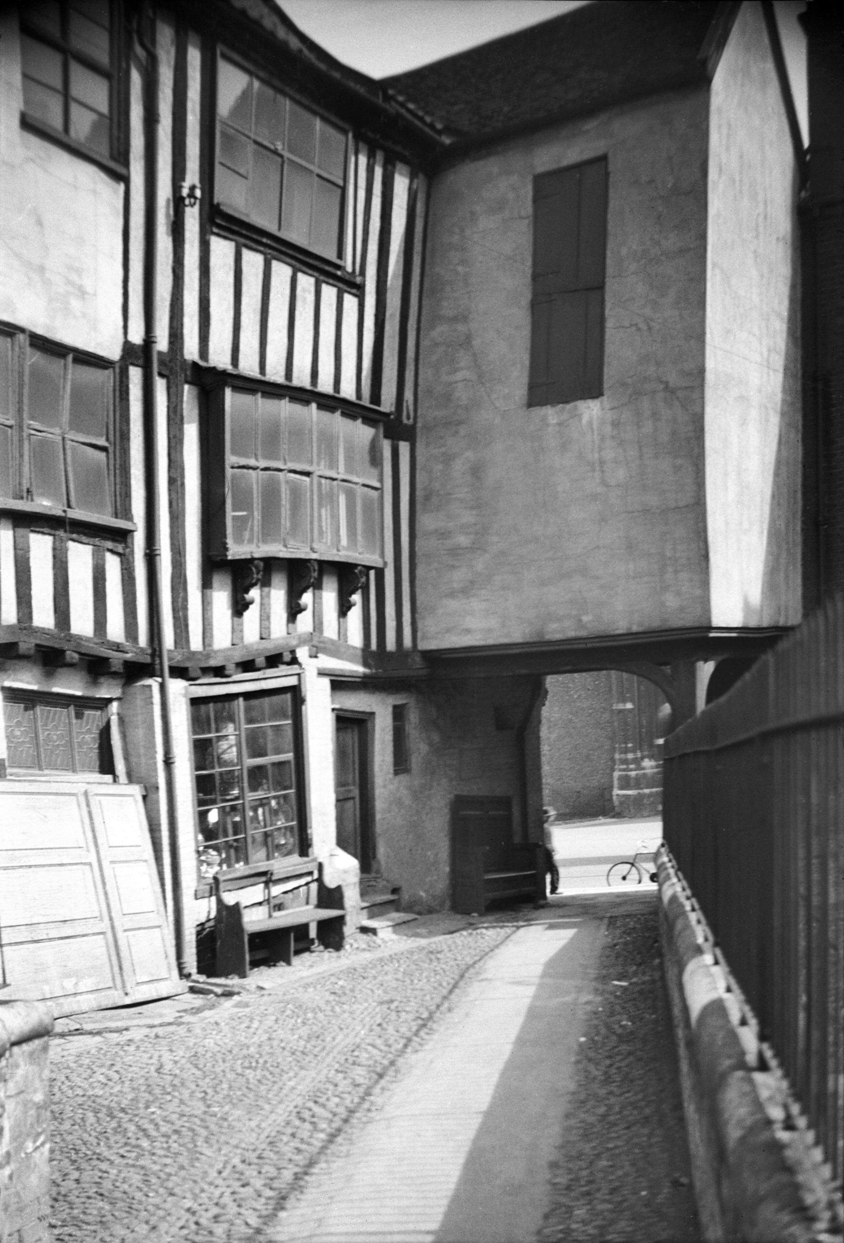
Unfortunately, the church is closed at the moment, but public entrance is usually allowed. This is the northern side of the church, where a path cuts across which is known as Tombland Alley. There were iron railings on the church side, but these were removed during the Second World War to be used as part of the war effort. The north porch of the building has been closed off and is now in use as a small chapel.

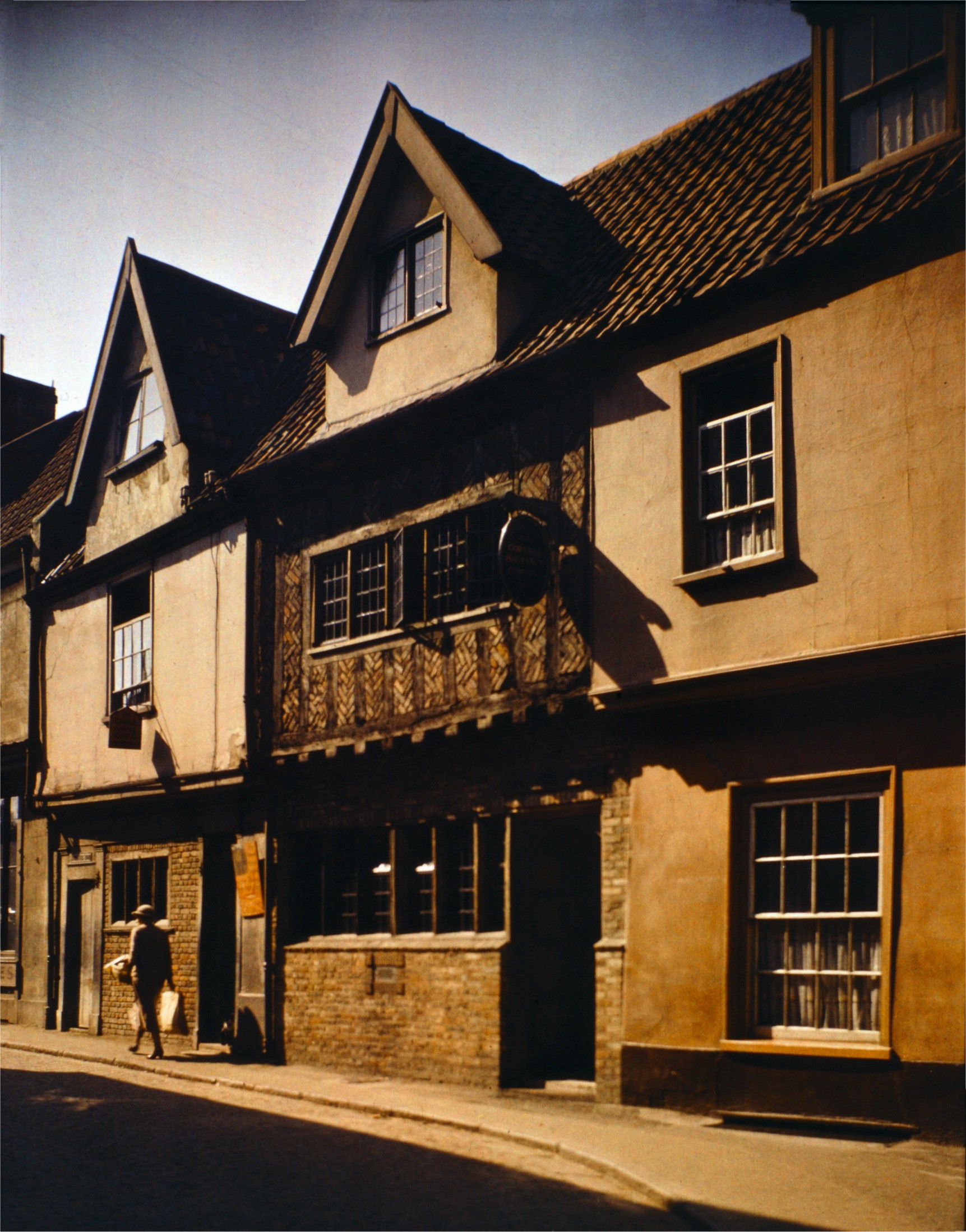
The rear of Augustine Steward’s House which dates from the mid-sixteenth century. This is a substantial building, and quite a survivor, with three floors and a basement, stretching back some way from its frontage onto Tombland. The property takes its name from the man who commissioned it, Augustine Steward, who was the Sheriff of Norwich in 1526 and Mayor of Norwich in 1534, 1546 and 1556. It’s thought that the building was completed in 1549, although it was in a state of some disrepair towards the end of the nineteenth century and needed substantial renovation. The roof was also badly damaged during a fire which took place in 1944. There’s a George Plunkett photo of these properties which he took in 1935.

Augustine Steward’s house is to the left and straight ahead is Tombland and Norwich Cathedral. There’s something quite delightful about the wonkiness of these buildings and how repairs have had to work around these little idiosyncrasies.

This was once the house of Christopher Jay, the Mayor of Norwich, and he wanted something quite grand at the entrance to his residence. So, he installed statues of Hercules and Samson, likely in around the late 1640s. They have become something of a Norwich icon, but the two wooden statues there now are modern replacements. The originals were removed in the 1990s and were left to dry out by Norfolk Museums Service so that they could be restored and put on display. It was discovered that the statue of Samson was covered in sixty layers of paint and was original, dating to 1647, although Hercules was a Victorian replacement. The building which they’ve guarded has been used for multiple usages, including perhaps most famously a nightclub for some decades. There was some controversy, and perhaps quite rightly, when these statues were painted red when a restaurant took over the premises a few years ago.

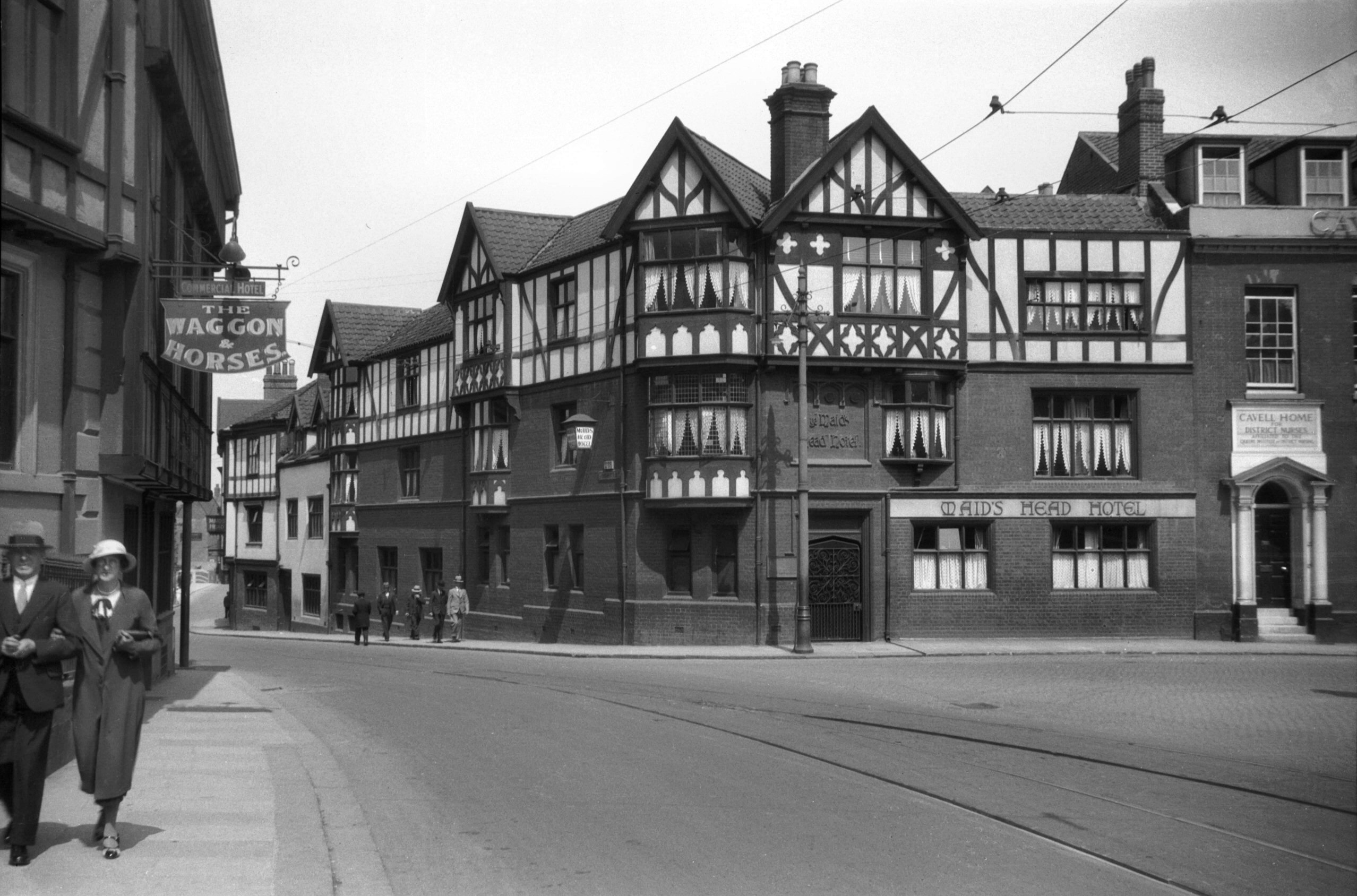
Next door is the Louis Marchesi pub, which has been a licensed premises since around 1770, when it was known as the Waggon & Horses. There was previously a fourteenth century building here and the crypts of that were retained when the newer structure was added on top and the Tudor effect is fake and dates to the early twentieth century. The pub was renamed the Louis Marchesi in 1976 and changed again to the quite drab name of Take Five in 2004, but since 2017 the Louis Marchesi name is back.
Louis Marchesi (1898-1968) was a local man and he founded the Round Table movement, a charitable organisation for young men. Wikipedia notes that Marchesi was also the man who came up with the “There are things we must do, there are things we can do and there are things we should do”, although I haven’t checked that little bit of information….

Today this is known as Waggon and Horses Lane, after the pub (before it was renamed to the Louis Marchesi), but it was previously referred to Elm Hill Lane and it connected to Elm Hill Street at its other end. This was all a bit confusing, so Elm Hill Street became known simply as Elm Hill, and this street was renamed.

The Black Horse pub, the section on the left which until recently was the Black Horse bookshop and is now an Indian restaurant.

This was Jonathan’s favourite discovery of the day and I must admit, I’ve never noticed it here. It’s the “Black Horse Skittle Saloon”, the former skittle alley of the Black Horse pub. There’s plenty more information about the Black Horse at the Norfolk Pubs web-site.

The main part of the building is now an opticians, but the black horse remains.

The parish boundary cuts across Wensum Street and includes the rear of the Maid’s Head hotel.

The frontage of the Maid’s Head hotel, which claims to be the oldest hotel in the UK. I think that’s perhaps a little arguable (more on that on the Guardian’s web-site), but there’s certainly a long heritage to this building and a long history of hospitality. The hotel notes on its web-site:
“The first Norman Bishop of Norwich, Herbert de Losinga had his original palace here, so we base our claim on the site’s continuous use for hospitality since the middle of the 1090s.”
They also have some old images of the hotel, both internally and externally. The mock Tudor frontage on this section dates from the 1890s and George Plunkett has a photo of this side of the hotel which he took in 1934.

This door is a modern recreation and it’s to note that Thomas Anguish (1538-1617), the Mayor of Norwich in 1611, lived here. Anguish left money in his will for a children’s hospital and this was founded in 1618, the year after his death.

This is the rear of the Maid’s Head and the old map notes that there was a Bishop’s Palace in this area, which fits in with the information provided by the hotel itself. I feel that I need to learn more about this, as I didn’t know that such a building ever existed on this site.

The Erpingham Gate isn’t in the parish, but the boundary reaches the wall.

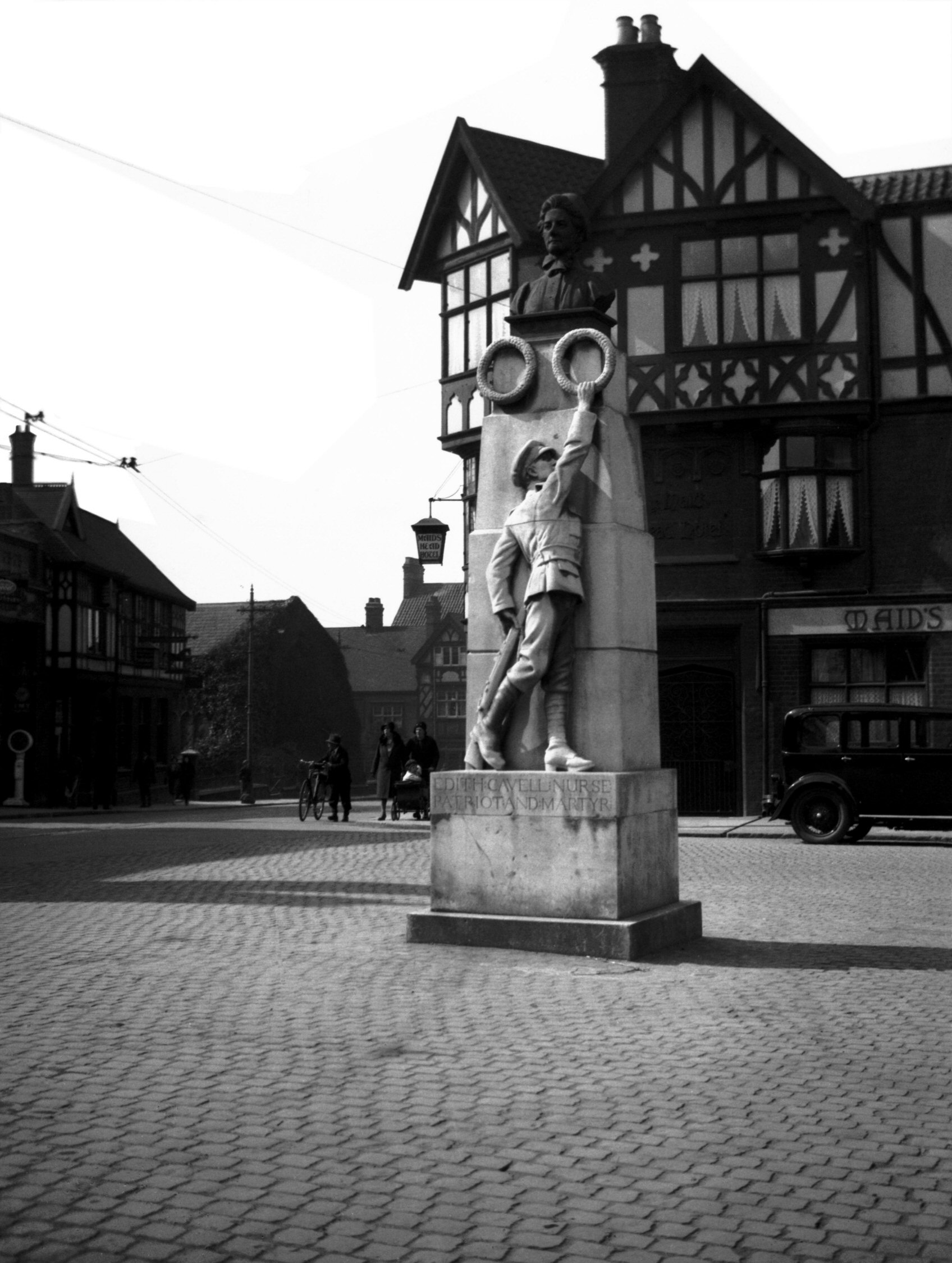
The statue of Edith Cavell, which was moved here a few years ago from the traffic island that was located a short distance away. It’s easier to see the statue in its current location, as there’s less chance of being run over, but George Plunkett has a photo from 1932 which shows its former position in front of the Maid’s Head.
Edith Cavell (1865-1915) was the first of four children of the vicar of Swardeston and she worked in this area and in Brussels in a role looking after children. She then trained as a nurse and worked in London and Manchester, before moving permanently to Brussels, which would have been quite an adventure for the time. She decided to stay in Brussels to help British and French soldiers, which included hiding over 200 of them from the Germans. Someone betrayed her to the Germans and she was sentenced to death by a military court, being shot at dawn on 12 October 1915. She was buried at Norwich Cathedral on 15 May 1919 following a memorial service which took place in Westminster Abbey.
Cavell’s death was used as propaganda by the British and the allies, to show the horrors of the Germans in shooting a nurse. There was significant international condemnation for the Germans and numerous attempts were made by countries to get the execution suspended. This wasn’t one of those decisions which was undertaken by an impulsive German soldier, this was a real dilemma for the German authorities who gave consideration to what they were doing. They didn’t want Cavell inspiring a wave of young women to offer resistance to the Germans, so they went ahead with the execution as a warning of what would happen to others who sought to repeat her rebellious efforts.

This stretch of wall behind Edith Cavell’s monument had buildings that joined onto it in the past and although they’ve now been swept away, some of the marks are still visible.

Most of the Edith Cavell branding has been removed from the pub, having been replaced by Prime Restaurant signage. The Norfolk Pubs web-site mentions that it was opened in the mid-nineteenth century when it was known as the Tombland Stores until 1879, then the Army & Navy Stores until 1981 before taking its current name (bar a short spell as Coles).

The bottle and jug entrance to the pub, for those customers who wanted to take beer away with them, with what is likely Victorian etching which has survived the decades.
And that’s another parish done, surprising me that there were a considerable number of historic bits and pieces that I hadn’t noticed before, not least some of the graves around the church of St. George and also the skittle alley at the rear of the Black Horse.