
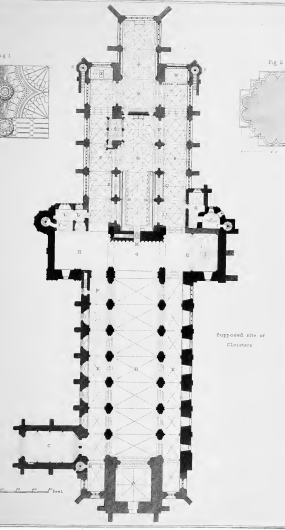

Above is a plan of Christchurch Priory which was drawn in the early nineteenth century and it notes the “supposed site of the cloisters” and this is terminology which has been used more recently. I don’t claim to be a cathedral expert, but I’m struggling to see that there’s much “supposed” about it and it seems quite definite. But, I guess that they’re using the correct historical term for when there isn’t direct evidence…. They were likely pulled down just after the Reformation, when the church was saved from destruction by the townspeople who petitioned King Henry VIII to keep it as their parish church.

The building on the right is obviously post-Reformation and it’s connected now as part of a relatively new development when a closed up Norman door has been reopened.

This seems to me to inevitably be the site of the former cloisters which once housed an early school.

The range would have gone along here, with the doorway on the left being the access point. Those arches are Norman (well, not the restored one on the left) and I imagine were ornamental to the cloisters.
It does feel that it would be nice, without wanting to remove the Priory’s parking spaces, to lay the site of the former cloisters out and make a little lawned area in the centre (I think called a garth). I mean, I’m sure the Priory is more concerned with the current building not falling down (it’s been on the heritage at risk register), but maybe if they one day get the money…..