Category: Norfolk

  • Streets of Norwich – School Lane

    Streets of Norwich – School Lane

    Part of my Streets of Norwich project….

    School Yard is located off of Bedford Street, just to the left and above of the letter B of Bedford in the above map from 1885.

    This map from the 1830s suggests that this street was then known as the Hole in Wall Lane, with 27 representing the Girls Charity School. It’s from this that I assume the street takes its current name.

    This leads through to St. Andrew’s Street, although I’m not sure that there is a right of way down there.

    The building on the right is a former granary, but its frontage is on Bedford Street.

    The sign with white writing on a black background denotes that this is the boundary of St. Andrew’s parish.

  • Streets of Norwich – Old Post Office Yard

    Streets of Norwich – Old Post Office Yard

    Part of my Streets of Norwich project….

    Looking into Old Post Office Yard, which is accessible from Bedford Street. Bedfords Bar now takes up much of this little arrangement, they’ve also got a fourteenth century undercroft in their building, which is all to the right once going through the arch. This building was saved in the 1980s and George Plunkett’s archive has a photo of what it once looked like.

    The building on the left-hand side of the arch was once the Nelson Tavern, with Bedfords Bar being on the other side to this. There was a Bedford Arms, but that was further down Bedford Street. The Norfolk Pubs web-site mentions that the Nelson Tavern was in operation from the mid-nineteenth century until it was closed down in 1918, during the period when the Government wanted to cut down on the number of licensed premises. It was also known, quite ridiculously perhaps, as the Pink Dominoes in 1881 (that’s almost a gastropub name from today) and as Klondyke towards the end of its existence as a pub. History often comes full circle though and it’s now a licensed premises once again, known as Frank’s Bar.

    The Post Office connection is better described from St. Andrew’s Street (which is what the court backs on to), so more on that another time.

  • Streets of Norwich – Opie Street

    Streets of Norwich – Opie Street

    Part of my Streets of Norwich project….

    Norwich in the 1880s, with Opie Street not having change much since then. It connects Castle Meadow to London Street. The name of the street did have to be changed, as the legacy of the medieval period was that it was called Gropekuntelane, for reasons of prostitution, so it was changed in the 1860s to be named after Amelia Opie. Opie was a local woman who was a Quaker, a writer and she also involved herself in politics, particularly in the anti-slavery movement.

    The street had also been called Devil’s Alley.

    On the wall just to the left of the hairdressers on the right-hand side of the photo is a stone plaque dating from around the 1930s marking where a sedan chair stood for hire in the early nineteenth century.

    The street is a little steep (especially for Norfolk) and at one point there were steps along part of its route up to Castle Meadow.

    A post-box from the reign of King Edward VII. One thing I didn’t know until today, and it’s one thing that I didn’t really need to know, is that the Post Office don’t need planning permission to put a new post-box up. So they can shove them where they like, which must be an exciting possibility.

    What is now Trailfinders was once The Queen public house.

    In the 1939 register, Louis Marchesi was living at number 6 Opie Street, a man who founded the Round Table movement in 1927. There’s also a pub named after him opposite the Erpingham Gate, fortunately reverted back recently after it was briefly renamed to Take 5.

  • Panxworth – All Saints Church

    Panxworth – All Saints Church

    This is one of my favourite churches in Norfolk, or at least, what’s left of it.

    The church was originally built in the fourteenth century, but as can be seen from this 1826 map, at this stage the church was in ruins (it’s located on the map just after the word ruins, at the little cross). It’s notable that there’s nothing else around there in terms of residential properties, the community had literally moved on. It’s not known when the church fell into ruins, but it was probably around the sixteenth century, which would coincide with depopulation in the area.

    However, the Victorians in a surge of confidence about church-going spent a fair sum of money on bringing the building back into use. An article in the Norfolk Chronicle in September 1845 noted that £500 was needed to complete the project and the local landowners made a donation, and there were events held including a “fancy fair”. At the fair there were “drawings on the tables of the intended design, with the building in the style of the fourteenth century, with a nave and chancel”.

    The project (there’s a plan from 1846 here) was overseen by James Weston and he didn’t really do much work to the tower itself, just tidying the structure up and adding a new nave. This plan worked for a while, with the church remaining in use until 1959 and it was finally declared as redundant in 1976. As usual, the wonderful George Plunkett has a photo of the church as it looked in the 1970s.

    Rather than repair the nave, which by the 1980s was becoming in need of some attention, they knocked it down, which wasn’t a huge historical loss as it was a Victorian structure anyway. So, in 1981, the nave and the south porch were taken down. As if that wasn’t enough for the church, a lightning strike hit the tower in 2005, which required more repair work.

    A damaged window frame, but this looks original from the fourteenth century (the frame, not the damage).

    Inside the church tower.

    The churchyard, where the graves are still tended.

    And there’s the tower, standing somewhat adrift in the landscape. Over recent years there have been rumours that the site has been used for Satanic worship and for a while the site was closed off. Fortunately, the structure is now accessible again for visiting and I think it still looks elegant. I do though still feel sorry for those Victorian donors, who contributed money to make it an operating church once again, but instead it’s come to this.

  • Norwich – St John the Baptist’s Church, Timberhill (James Tillott)

    Norwich – St John the Baptist’s Church, Timberhill (James Tillott)

    Further to my post about St. John the Baptist’s Church at Timberhill, this is one of the graves which is located within the building.

    I liked this tombstone, it’s so very eighteenth century and it’s in a reasonable state of repair. The tomb holds the graves of James Tillott (1715-1763) and his wife, Elizabeth Tillott (1714-1783), with James apparently being “a good husband, a humane master and a sincere friend”. The church’s records for both of these burials have survived, so it’s known that James was buried on Tuesday 28 June 1763 and Elizabeth was buried on Monday 16 June 1783, both three days after they died.

    Tallow chandlers usually made and sold candles out of animal fat that were used in homes, whilst wax chandlers usually made and sold candles out of beeswax that were used in churches and grander residential properties.

  • Norwich – St John the Baptist’s Church, Timberhill

    Norwich – St John the Baptist’s Church, Timberhill

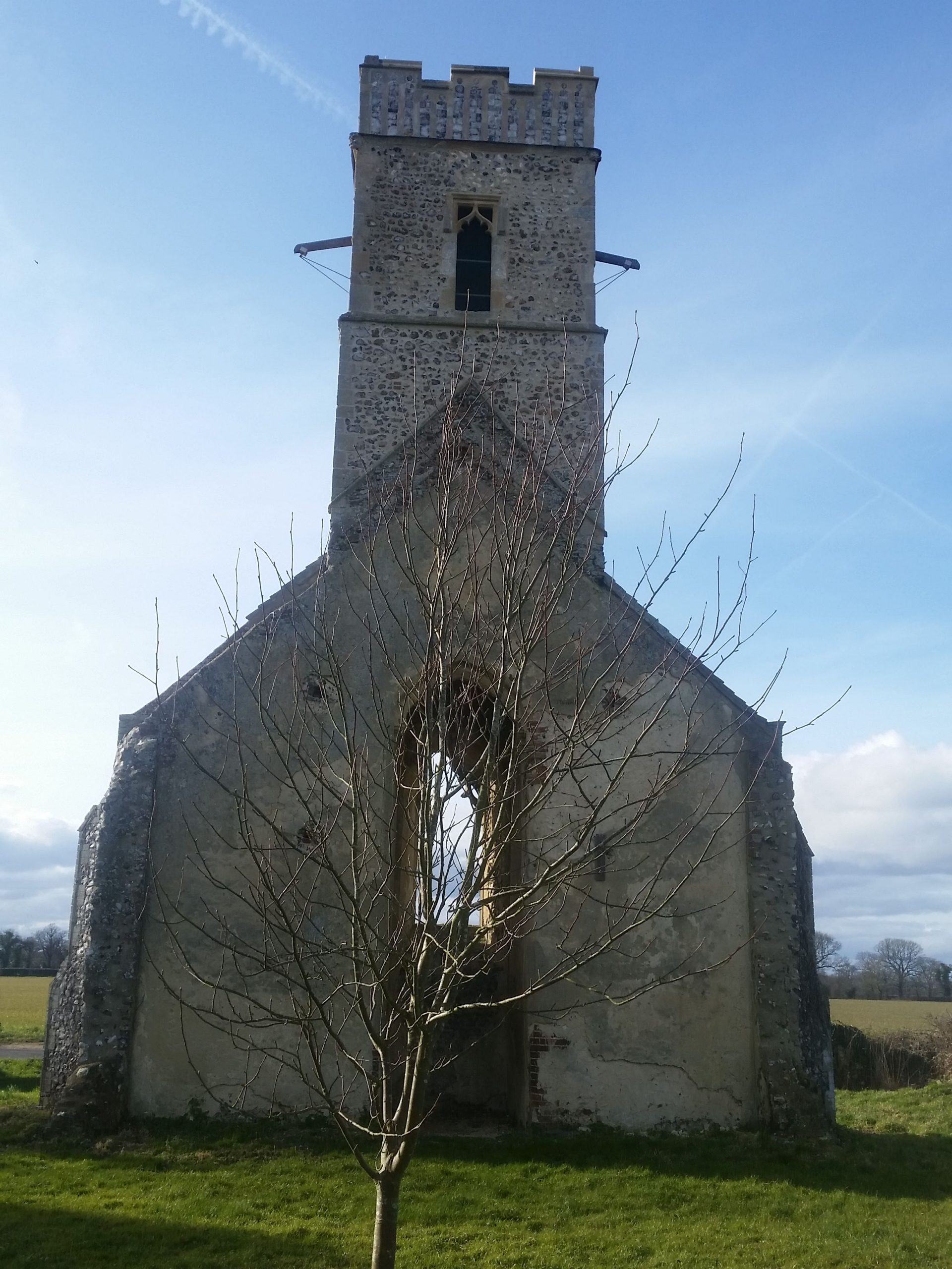
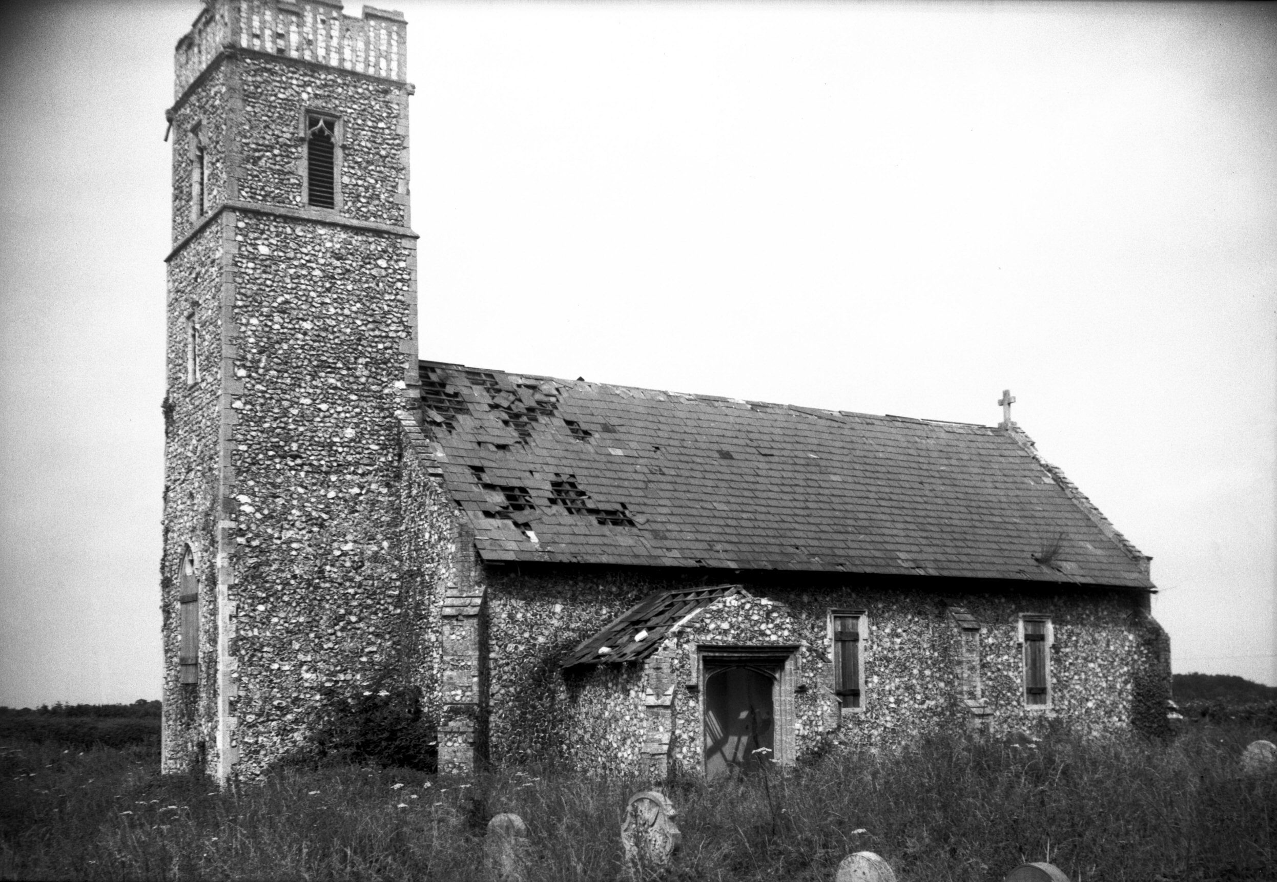
    This church is the main Anglican church of the Catholic tradition in Norwich and the building dates to the eleventh century. It was perhaps constructed shortly after the building of Norwich Castle, which had forced some urban replanning.

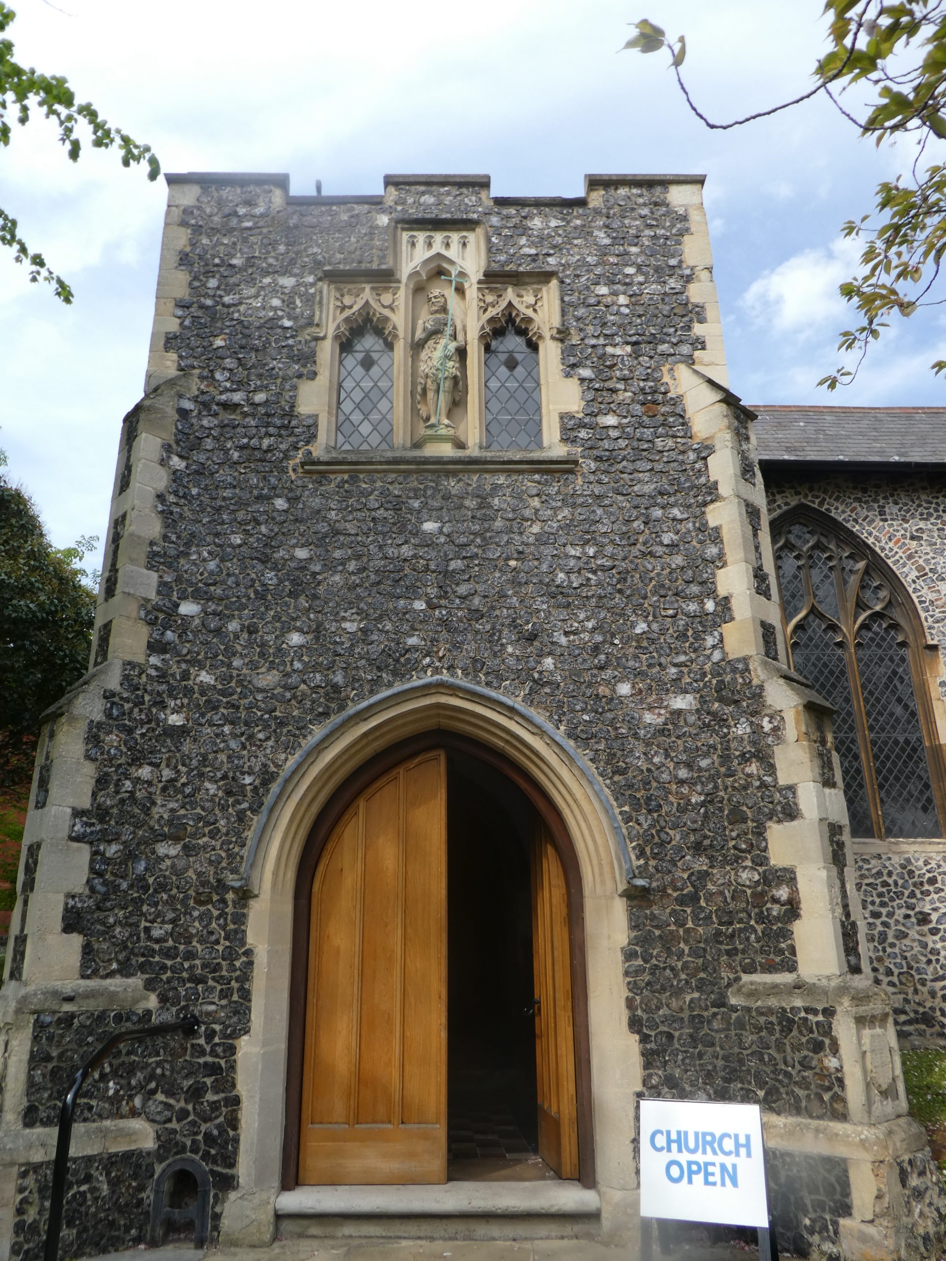
    The tower fell down in 1784, which wasn’t ideal, but a shortened version was added in 1877. The church had been through some troubled times before the tower fell down, being stripped of its icons in the sixteenth century and then not being looked after structually. They also flogged off the church bells to help pay for the repair of the building, which I suppose makes sense given they didn’t have a tower to put them in.

    There are two different design styles, between the nave and the two aisles.

    Until 1828, the church had a thatched roof, which must have made for quite a sight. The more modern roof is a little less exciting, but the building is now at least in a good state of repair. Those little windows on the roof were also added in the nineteenth century, I’m not sure I like them, it reminds me of a house conversion.

    One of the few churches in Norwich which has replaced its railings, which were removed during the Second World War.

    The font, which dates to the eighteenth century, primarily as the one before got a bit broken when the tower collapsed. The rather large font cover is more modern, designed by John Howard and installed here in 1929.

    I bet this was the Victorians, so often careless with their placement of new church furniture. Although, interestingly, Father Ram, the controversial vicar in the late nineteenth century was determined to restore the building to how it looked in the medieval period, which included removing the George box pews.

    This stained glass window is from 1910, painted by Martin Travers.

    Looking towards the altar. I hadn’t expected to go in this church when I walked by a few years ago, hence why I only had my phone and that at the time didn’t exactly produce quality photos. I’ll go back after this virus is over to take better ones.

    The rood beam with its three figures, introduced by Father Ram, with some opposition to his High Church reforms. Unfortunately, the historic rood screen was removed at the same time.


  • Dictionary of the Vulgar Tongue – Day Thirty-Four

    Dictionary of the Vulgar Tongue – Day Thirty-Four

    The Dictionary of the Vulgar Tongue was first published at the end of the eighteenth century, and given that the Coronavirus crisis is giving too much time to read books, I thought I’d pick a daily word from it until I got bored…..

    Bones

    One of the shortest definitions provided by the dictionary so far, simply saying “dice”. The reason for the word is just as simple, as for most of human history, dice were made from animal bone. There were always alternatives such as wood, metal, antlers, stone and no doubt many more materials, but bone was likely from where it started. Dice have for centuries also been loaded, and there’s another phrase from this book on that (in about 40 days), with weights hidden inside the dice to fool the unsuspecting. I’m still impressed that King Henry VIII lost the bells of St. Paul’s Church whilst throwing his bone dice, not an ideal situation for him….

  • Streets of Norwich – Haymarket

    Streets of Norwich – Haymarket

    Part of my Streets of Norwich project….

    The Haymarket is a slightly quirkily defined area, cutting in between Brigg Street and the Market Place (Gentleman’s Walk), as well as joining in what is now called Millennium Plain and William Booth Street. For a while this was the city’s Jewish quarter and there was a synagogue here, before the Jews were expelled in 1286. Haymarket was also the annex of the main market place where hay and straw was brought for sale, a role it had for many centuries.

    The temporarily boarded up McDonald’s, which was formerly the George & Dragon pub. it was a pub from the 1730s until 1988, when it was converted first into a bank and then into McDonald’s in 2002. This really should be a pub again given its long heritage….

    The building at the rear was the once impressive Lambert’s warehouse, demolished in around 1970 and replaced with an awful bland building. On the right-hand side is St. Peter Mancroft, Norwich’s largest medieval parish church.

    Some sculptures. In another brilliantly inspired move, Norwich City Council ripped out the fountains and seating which were here, replacing them with nearly no seating and more paving slabs. This used to be a little park area in the mid-twentieth century, something that could perhaps be brought back in.

    The Thomas Browne statue, which was placed here in October 1905, to mark the three hundredth anniversary of his birth.

    Interestingly, where the statue sits today, there used to be a pub, the White Horse, which was demolished at the end of the nineteenth century (the map above is from 1885), in around 1898. For much of the nineteenth century it had also been called the Seed Mart, which is perhaps a unique pub name.

    Another dreadful modern building on the left-hand side, another in a substantial series of incompetent decisions from local planners. It was built as Peter Robinson’s store in the 1962, but it required the demolition of the Gaumont theatre, formerly the Haymarket Picture House, in 1959.

    The council have mauled this square so much that it’s lost nearly all of its character. Not that long ago it had a pub that was 250 years old, a huge theatre and an historic warehouse, now it’s got some generic retail buildings that give no nod to the heritage here and nearly no seating areas. There is though some heritage to the buildings which are on one side of the Haymarket, at the rear of this photo, more on which in another post.

  • Streets of Norwich – Swan Lane (Jem Mace)

    Streets of Norwich – Swan Lane (Jem Mace)

    As a follow-up to my post about Swan Lane.

    On the side of Turtle Bay is a sign marking that Jem Mace, “the father of modern boxing”, was the landlord of the White Swan public house. That building was demolished in the mid-nineteenth century, with the replacement structure now being the home of Turtle Bay.

    Jem mace.jpg

    James Mace was born on 8 April 1831 in Beeston, near to Dereham, the fifth of eight children of blacksmith William Mace and his wife Ann. He got into boxing young, which at that time was usually bare knuckles, as boxing gloves weren’t required until 1867. Originally he was interested in a career as a musician, and it’s said that this dream ended when three youths smashed up his violin for no reason in Great Yarmouth, which was also said to have fuelled his anger.

    Mace became the Heavyweight Champion of England in 1861, the English Middleweight champion in 1863 and the World Heavyweight champion in 1870. It was this fight that was perhaps the most important of his career, fought in Kennerville in Louisana (a place I’ve been when I stayed at the Kenner Econolodge, as it’s now effectively all part of New Orleans). The prize fund for the winner was £3,000, which is around £200,000 in today’s money, so this was a huge event.

    Mace owned the White Swan from 1857, during which time he managed in 1858 to be fined a sizeable sum for using bad language to a woman. It’s not clear when he left, likely not until the early 1860s when the building was taken down. He died on 30 November 1910 in Jarrow, County Durham, certainly an eventful life….

  • Streets of Norwich – Eastbourne Place

    Streets of Norwich – Eastbourne Place

    Part of my Streets of Norwich project….

    Not much has changed on this little street since the above map was published in 1885. The only change is to the name, as St. Faith’s Lane used to go all the way from Tombland to King Street. It sort of still does, although St. Faith’s Lane as a road name stops at Prince of Wales Road, then becomes Eastbourne Place and then becomes Mountergate.

    This map, from twenty years earlier, seems to suggest that Eastbourne Place was constructed in the early 1860s as there are no buildings marked here. Why they choose the name Eastbourne, I have no idea…..

    And the building would have been possible because of the construction of Prince of Wales Road, which was in the late 1850s (the above map is 1849), which finally opened in 1862.

    The area in front of Eastbourne Place has been messed around by the council on numerous occasions, the once little wooded area barely now exists, although at least the nearly always broken public toilet has been removed.

    The building on the left-hand side, which is now blacked out, was until the 2019 a branch of Domino’s, but it has a long history of being a food outlet, as in the 1860s John Sword opened up a refreshment rooms here which sold tea, coffee and other drinks. He also provided accommodation, which I assume was in the rooms which are now occupied by the nightclub Loft.

    The Presto Bar was also here, which housed a 60-foot long model car track, which still exists as Presto Park, although has been much changed over the decades. I think the Presto Bar occupied the same space as the refreshment rooms opened up by John Sword.

    This area looks better now than it has for some years, the space in front has been opened out and the number of cars reduced, although some more greenery would be nice. And someone needs to open up where Domino’s once was….