Category: Streets of Norwich

  • Streets of Norwich – Swan Lane (Jem Mace)

    Streets of Norwich – Swan Lane (Jem Mace)

    As a follow-up to my post about Swan Lane.

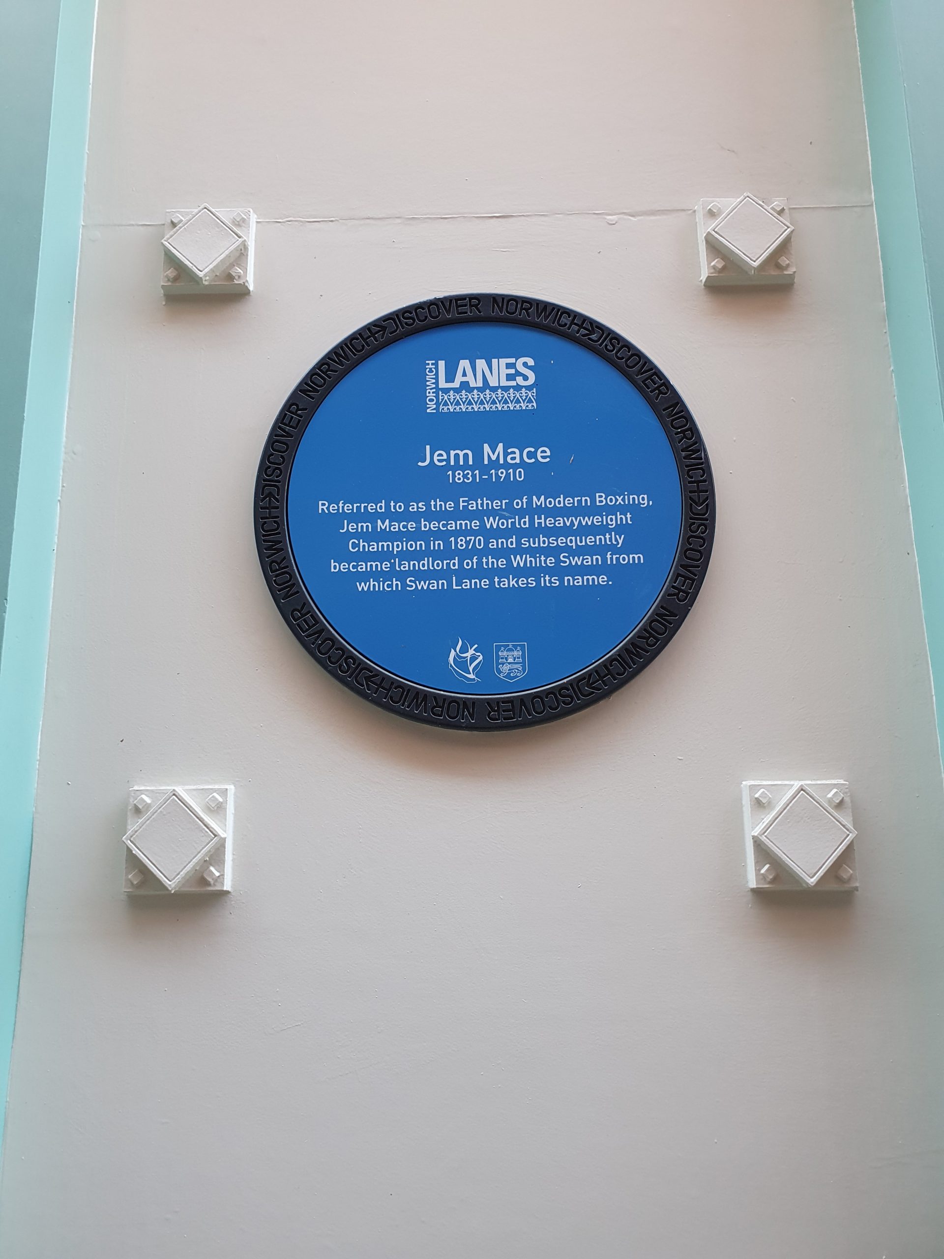
    On the side of Turtle Bay is a sign marking that Jem Mace, “the father of modern boxing”, was the landlord of the White Swan public house. That building was demolished in the mid-nineteenth century, with the replacement structure now being the home of Turtle Bay.

    Jem mace.jpg

    James Mace was born on 8 April 1831 in Beeston, near to Dereham, the fifth of eight children of blacksmith William Mace and his wife Ann. He got into boxing young, which at that time was usually bare knuckles, as boxing gloves weren’t required until 1867. Originally he was interested in a career as a musician, and it’s said that this dream ended when three youths smashed up his violin for no reason in Great Yarmouth, which was also said to have fuelled his anger.

    Mace became the Heavyweight Champion of England in 1861, the English Middleweight champion in 1863 and the World Heavyweight champion in 1870. It was this fight that was perhaps the most important of his career, fought in Kennerville in Louisana (a place I’ve been when I stayed at the Kenner Econolodge, as it’s now effectively all part of New Orleans). The prize fund for the winner was £3,000, which is around £200,000 in today’s money, so this was a huge event.

    Mace owned the White Swan from 1857, during which time he managed in 1858 to be fined a sizeable sum for using bad language to a woman. It’s not clear when he left, likely not until the early 1860s when the building was taken down. He died on 30 November 1910 in Jarrow, County Durham, certainly an eventful life….

  • Streets of Norwich – Eastbourne Place

    Streets of Norwich – Eastbourne Place

    Part of my Streets of Norwich project….

    Not much has changed on this little street since the above map was published in 1885. The only change is to the name, as St. Faith’s Lane used to go all the way from Tombland to King Street. It sort of still does, although St. Faith’s Lane as a road name stops at Prince of Wales Road, then becomes Eastbourne Place and then becomes Mountergate.

    This map, from twenty years earlier, seems to suggest that Eastbourne Place was constructed in the early 1860s as there are no buildings marked here. Why they choose the name Eastbourne, I have no idea…..

    And the building would have been possible because of the construction of Prince of Wales Road, which was in the late 1850s (the above map is 1849), which finally opened in 1862.

    The area in front of Eastbourne Place has been messed around by the council on numerous occasions, the once little wooded area barely now exists, although at least the nearly always broken public toilet has been removed.

    The building on the left-hand side, which is now blacked out, was until the 2019 a branch of Domino’s, but it has a long history of being a food outlet, as in the 1860s John Sword opened up a refreshment rooms here which sold tea, coffee and other drinks. He also provided accommodation, which I assume was in the rooms which are now occupied by the nightclub Loft.

    The Presto Bar was also here, which housed a 60-foot long model car track, which still exists as Presto Park, although has been much changed over the decades. I think the Presto Bar occupied the same space as the refreshment rooms opened up by John Sword.

    This area looks better now than it has for some years, the space in front has been opened out and the number of cars reduced, although some more greenery would be nice. And someone needs to open up where Domino’s once was….

  • Streets of Norwich – Bank Street

    Streets of Norwich – Bank Street

    Part of my Streets of Norwich project….

    The above map is from the 1870s, with no substantial changes to Bank Street since then, although the area to the south of it was turned into a hotel.

    On the left is the entrance to what was Wade’s Court, although has also been known, and is now signed as Wade’s Yard. On the right is the back of the Royal Hotel, which takes up the whole block and which was built between 1896 and 1897. When they were demolishing the buildings on the site they discovered archaeological remains from the outer precincts of Norwich Castle. Built with 65 bedrooms for guests, the hotel remained trading until 1977 when a lack of car parking saw its demise. Fortunately, plans in the 1970s to demolish it and replace it with a glass office block were rejected, with the building more recently being used for offices.

    The second building on the left, with the sign hanging up above the door, is the former Bank Tavern. Later on part of the Steward & Patteson brewery, this pub first opened in the early part of the nineteenth century and it remained trading until November 1965.

    Looking back down Bank Street towards Bank Plain.

  • Streets of Norwich – White Lion Street

    Streets of Norwich – White Lion Street

    Part of my Streets of Norwich project….

    White Lion Street runs from Gentlemans’ Walk and bends into Orford Hill and Red Lion Street, all very much unchanged over the last 150 years. The street takes its name from the former White Lion pub, but was originally called Sadelere Rowe in the thirteenth century due to the saddle-making industry here, and later Lorimers Rowe due to the harness strap makers that were located along the street.

    Although it’s relatively short, there used to be a few pubs down this street, with the Adelphi (13 White Lion Street), the Fruiterers Arms (2-4 White Lion Street) and the White Lion / Haymarket Stores (10 White Lion Street).

    The end of the street, which is all now pedestrianised, which joins Gentlemans’ Walk.

    Looking along the road to the Castle Quarter shopping centre. WH Smiths is on the left, this is the former Fruiterers Arms and is a real loss to the city centre as this would be a rather lovely setting for a pub. The building dates to the seventeenth century and was a pub from the mid-nineteenth century until 1989.

    Looking back towards to the market place area. The building to the left of Ladbrokes was Costa, but they closed in early 2020, so it’s up for rental, with this being the former Haymarket Stores pub. The Haymarket Stores, which was once known as the White Lion, closed in 1974.

    Back in 1912, the businesses along the street were:

    NORTH SIDE

    1 – Pearks, grocers

    1A – Albert Turner, confectioner

    3 – Cozen Randall, hairdresser

    5 – Sam Ellis, fruit merchant

    7 – W. Fletcher, butchers

    9 – Eastern Counties Rubber Company

    11 – London & Norwich Cycle & Rubber Company

    13 – Back’s, wine and spirits merchants

    15 – Back’s, tobacconists

    17 – Henry Moore William, wine and spirits store

    19-21 – Grix William, dining rooms

    SOUTH SIDE

    2-4 – Fruiterers Arms, pub

    6 – Edward Richard Pooley, shoe warehouse

    10 – White Lion, pub

    12 – E. Reeve & Son, grindery


    The 1939 register had the following residents living on the street:

    1A – Rosetta Clarke, Douglas Clarke, Frances Webster, Olive Johnson

    6 – Norah Sage

    10 – Edward Thaxton, Emmeline Thaxton, Leonard Thaxton

    13 – William G Gerry, Lily Gerry, William J Gerry

  • Streets of Norwich – King Street (191-197 King Street)

    Part of my Streets of Norwich project, although I’ve had to break King Street up since it’s so long….

    The site of what was once 193 to 197 King Street, sadly demolished in the mid-twentieth century. The building which stands is the former Ferry Boat Inn, at 191 King Street.

    There was once a yard at 193 King Street, known as Wickham’s Yard, which went down to the river, but this went when the properties at 193 to 197 were demolished. Five properties along this yard, which was pretty much all of it, came up for sale en masse in 1908 with the purchase including the yard itself and river access.

    There was an archaeological dig here a few years ago when a building project was planned, but there hasn’t been much progress recently. But the armchair remains….

    The Ferry Boat Inn, which closed in 2006 and unfortunately is unlikely to ever reopen now. This is particularly sad as it’s one of the few pubs which was left along the King Street from the many which once stood along here. The building has been used as a pub since at least the beginning of the nineteenth century, and was likely a private residence before then dating back to the seventeenth century.

    The pub was formerly known as the Steam Barge and the Steam Packet, taking its current name as this was the location for the boatmen who carried people and goods across the River Wensum. The pub is Grade II listed, so it should remain standing as a residential property even when the rest of the site is converted into housing. For a short while in 1987 the pub’s landlord was Steve Wright, later convicted as a serial killer who killed five women in Ipswich.

  • Streets of Norwich – Blackfriars Street

    Part of my Streets of Norwich project….

    Blackfriars Street, which connects Fishergate with St. Saviour’s Lane.

    This is a new street, which follows the same route as the southern half of Peacock Street, but it got split up when the Inner Ring Road was constructed. George Plunkett’s web-site has some photos of the amazing properties which were once located down this street. Some of his photos of this street from the 1930s make it look quite magical and I’m sure that it would have been seen today as very on-trend and probably had locations selling craft beer down it.

    Council housing on the left, a new building complex of flats and houses behind them at the rear on the left, with Smurfit Kappa (formerly NCB) on the right. Very many years ago I thought that that this was the National Coal Board, but it was Norwich Corrugated Board. Shame it isn’t Norwich Craft Beer, but that’s a different matter.

    Before this street was known as Peacock Street, it had the rather more exciting name of Rotten Row, likely because it was once a water course or ditch which had got a bit, er, damp and mouldy.

    And, onto the name of this street, Blackfriars Street. This would be a wonderful name for a street where perhaps the Blackfriars once had a monastery, or perhaps a barn or some other connection. But, no, the Blackfriars had their religious house elsewhere in the city, which is today used for the Norwich Beer Festival amongst other things.

    So, it seems that someone named the street Blackfriars Street since it is near to, well, Whitefriars. Which it has nothing to do with. The northern half of Peacock Street is still untouched and retains its name, but perhaps the council could have a little look at renaming this street as Rotten Row, because I like that name, it’s atmospheric and historic.

  • Streets of Norwich – Clarence Road

    Part of my little Streets of Norwich project

    This street was likely once much more peaceful in terms of passing traffic, but it has become the main route into the city centre from Yarmouth and is now the A1242.

    These properties would have been mostly occupied by the middle classes, and there have been several adverts from different houses over the years for domestic staff. In 1902, the owner of 10 Clarence Road was advertising for a housekeeper, noting that they must be middle aged and female. In 1889, the owner of 6 Clarence Road was also busy advertising, they wanted a “good general servant”, as opposed, I assume, to a bad general servant. Pretty much the whole street was advertising at this period though and in 1901 the owners at 7 Clarence Road wanted “a young girl” as their domestic help.

    By the time of the 1939 register, there was quite a variety of different occupations represented along the street, including a railway motor driver, a drapery buyer, a master butcher, an armature winding foreman, a barmaid, an electrical fitter, a gun maker, a typist, a radiographer, a law clerk and a retired leather agent amongst many others.

  • Streets of Norwich – Paradise Place

    This road cuts through from Rouen Road to Thorn Lane, but there’s not much evidence of history left here, because it was all rebuilt following the Second World War.

    The name of Paradise Place isn’t though modern and it dates back much further, with it likely being a garden area, as ‘paradise’ is an old English word for park. When the site was being redeveloped it was decided to reuse the old name for the new road within the housing development.

    I took the above photo standing in what was once Scoles Green (long ago Scholars’ Green), and I would have been able to see the Globe and Anchor pubs from there. Unfortunately, as the road layout has changed, there’s absolutely nothing left here from that period, not even the street line. There is today a development called Scoles Green located opposite on the other side of Rouen Road, which is at least some legacy from the name.

    There was a case in November 1890 which was an early claim of negligence, when Robert Clarke of 13 Paradise Place took legal action against the Prison Commissioners for England following an injury on scaffolding at Norwich prison at Mousehold Heath. The court dismissed Clarke’s pleas, saying that the Employers’ Liability Act didn’t cover the situation and the judge added:

    “These cases must be looked at very narrowly and very carefully, otherwise a burden would be put upon employers which would make the carrying on of a great work intolerable”.

    The Prison Commissioners were though gracious and they suggested that if Clarke didn’t pursue his claim further then they wouldn’t seek an order of costs. Mr. Clarke was unfortunate, as the Workmen’s Compensation Act 1897 would have likely have been a sufficient change in the law to mean that he would have won his case.

  • Streets of Norwich – Broadsman Close

    Part of my Streets of Norwich project…..

    There’s not much to Broadsman Close, although since I’ve decided to visit every road in the city, this had to be included. Unfortunately, there’s not a great deal that can be written about this short stretch of road.

    This is pretty much the limit of the road, an access to the railway sidings and also to a couple of retail outlets. There isn’t much history to this area either as this was once just railway land between one end of the coal yard and the the shunting area for freight trains. Before it was owned by the railways, it was just fields.

    And another view to the entrance of the close. The road was created during the whole Riverside development complex, so somewhere around 2001.

    The Broadsman was a passenger train operated by British Rail which ran from London Liverpool Street to Sheringham between 1950 and 1962. On this point, I’d quite like for services to be named in this manner again, in a similar way to the way that American train services are. The Sheringham Zephyr has a certain ring to it….

  • Streets of Norwich – Stracey Road

    Part of my Streets of Norwich project….

    This is Stracey Road, located off of Thorpe Road and connecting to Lower Clarence Road.

    There’s not really much change to the layout of this area over the last 125 years, with the church behind the properties off Stracey Road still there.

    This building at the end of the road and in the photo above is Marlborough House, which was turned from a private residence into a guest house in 1969. It was also though a dwelling house in the past, as is in March 1909 a William Coxall broke into the property and stole an overcoat, gloves and half a cake. No point going hungry if you plan to go burgling I suppose…..

    These were quite decent houses at the beginning of the twentieth century (I’m sure they are now as well) and there’s a reminder of this as many of them employed servants and maids. The residence at number 10 was looking for a “mother’s help” in December 1902 and they promised that the accommodation for the applicant wouldn’t be in the cellar or attic.

    I had better not upload every single one of the 1939 registers as part of this project, as that might be seen as too much of an infringement of copyright. But, in 1939, there was an inspector of taxes, a surgeon, a children’s nurse, a retired LNER inspector, a railway clerk, a warehouse goods clerk and an inspector for the LNER who all lived on the street.

    On the issue of the street name, I don’t know why it took the name Stracey Road, although the Stracey baronetcy is a local title and the family were important figures in Norwich during the nineteenth century.