Streets of Norwich – Baltic Wharf
Part of my Streets of Norwich project…. This post was updated in October 2023.

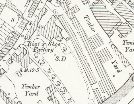
Baltic Wharf is a relatively new road, it follows the line of the trees on this map from around 1900. SD on maps from this period either means sun-dial or a single-drain, so that little tiny circle next to the S might be a sun-dial…. There was a Baltic Wharf in the nineteenth century, but that was located a little further down the river.

There’s not a great deal of historic interest on Baltic Wharf, which leads off Mountergate, with the exception of St. Faith’s House which is a listed building. It was built as a three-storey grand private residence in the eighteenth century, although it’s now used as offices.
There was a planning application put in on November 2018 to build seventeen dwellings around the building and to change the property itself by kicking the businesses out and putting five flats in. The road is next to the large St. Anne’s Quarter residential building development (I thought the word quarter was being phased out, it has been so over-used recently….) and so this was always likely inevitable.